Would a Karlsruhe Stadtbahn type of system, or a tram-train hybrid system work. An Alstom Bombardier Flexity Swift can do 100km/h.
Don’t think the SE Busway was ever built for heavy rail conversion.
Would a Karlsruhe Stadtbahn type of system, or a tram-train hybrid system work. An Alstom Bombardier Flexity Swift can do 100km/h.
Don’t think the SE Busway was ever built for heavy rail conversion.
I have reservations about any rail conversion of the Busway. I fear it would cause more headaches than it solves, and that any benefits gained from it wouldn’t be worth the price.
It was built for a light rail conversion in mind. I remember talking to Paul Lucas about it back when I was in High School. Whether that’s still feasible today depends. But definitely not heavy rail given the current standards.
I wouldn’t want it converted to heavy rail. Heavy rail should be considered for the corridor, though, whatever that requires, whether removing road lanes, resumptions, tunnelling, elevation, or most likely some combination of all four. It could even coexist with the busway, being an express service, where the busway serves intermediate stops.
My take on SEB lightrailification is that we definitely don’t want to run mixed LRT and buses, and in that case LRT would need to more than double the current busway peak capacity through Mater Hill (as in peak, more than half of all SEB buses go via the Captain Cook Bridge). That seems quite difficult. There’s also the question of exactly how many via-SEB corridors get converted to LRT and how many get done in the first hit - obviously you go down Mains Rd and out to Carindale but what about the 100, 120, 150, 180?
So instead we should leave it in place and dig a subway under Logan Rd (then Sunnybank + Browns Plains).
Quite a lot of Logan Road has enough space to just put light rail on the surface. Surely it’s possible to get a separated light rail line here while keeping two general traffic lanes per direction. Google Maps
I agree with your general view - leave the busway to its thing and do light rail separately.
I mostly agree, but there are some notable pinch points on Logan Road that would need to be considered - there’s a section through Holland Park near the Anglican Church where Logan Road condenses to 4 lanes with no shoulder and a medium no wider than a single car lane width.
It also gets pretty tight again near Glindeman Park along the main section of Logan Road - you do have the old southbound section of Logan Road along there, but it sits a few metres lower than that main road, and provides level access to the 16 or so houses along there as well as the park itself.
That’s off the top of my head - there might be additional ones.
Surface level class B ROW light rail is my preference for Logan Road, with some limited tunneling where it gets narrow.
On top of the ones already mentioned, around Greenslopes shopping centre is pretty limited, especially with all the intersections.
The main ones for me is between Kessels road and Upper Mount Gravatt state school, and between Mt Gravatt Showgrounds and the Red rooster (Mt Gravatt Central).
In the case of Kessels - to the school, my ideal is a dive into a tunnel in the gigantic parking lane outside of Palmdale. Surface somewhere around the sports fields on Klumpp Road. Super gold plating would be an underground station in the high density around Sanders Street
For the showgrounds, resume a little bit of the showgrounds at the northern end for the dive structure, and surface again somewhere around Red Rooster / caryards. Again bonus gold plating for an underground station / high density TOD at the site of the old shopping centre at Central fair.
So what’s the ultimate long term solution for the Gold Coast Line north of Kuraby? 30-40 years down the track.
Is it 4 track from Kuraby to Dutton Park? Which doesn’t really solve the slow alignment.
Or a separate alignment branching at Kuraby (when heading North)? Running subsurface, roughly along the Logan Rd Corridor? Perhaps with only 1-2 stations to significantly reduce costs and ensure the journey is time-competitive with cars, resurfacing in the Boggo Rd triangle and joining sector 3? Utilising the spare sector 3 capacity through the CBD, and then ultimately heading to NWTC (or some other new alignment) with a dive either at Alderley or Albion?
My preferred outcome (obviously foamy) is currently something like this:
This gets you to a situation where you can run Beenleigh or Flagstone trains via South Bank along with Cleveland trains, and whichever pattern does not go that way goes via CRR. With ETCS L2 installed this gets you to theoretically 12+tph for each line, or 24+ tph via CRR or via South Bank, and with no open LXs.
CRR will open at about 67% full in terms of trains/hour and about 44% full in terms of train carriages per hour, in peak direction (assuming 8tph each on Beenleigh & Gold Coast lines, and it will definitely be 6-car only this decade).
So to maximise the use of CRR with its 9-car platforms, we’ll need to run 9-car trains in the future. It makes sense that the newer/outer lines, in particular the Gold Coast line, be the ones to upgrade. Similarly Flagstone-Beaudesert could be built to allow for 9-car trains from the start. For a while you might expect to see CRR basically full in terms of trains/hour in peak and meeting capacity growth by lengthening trains on the Gold Coast and Beaudesert lines.
Western growth will prompt the Clevewich line (sector 4 / second cross-river tunnel). This will leave the Merivale Bridge practically empty, at maybe 1/6th utilisation. At the same time CRR will be getting fuller and fuller.
In the very long term, it also seems likely that only one of Beenleigh and Flagstone/Beaudesert should use CRR, as the tunnel fills up and the Clevewich line near-empties the bridge.
My contention is that it should be Beenleigh, not Beaudesert, that goes back over the Merivale bridge, as the argument comes down to difficulty of upgrading the entire Beenleigh line to 9-car VS quadding / bypassing the Salisbury-Kuraby stretch. (Beaudesert may or may not be built for 9-car trains initially, but as a new line it’ll be easier to convert it than do all the quadding, so I expect that’d happen first.)
I consider quadding Salisbury to Boggo Rd necessary in the long term to properly sectorise the CRR lines from the Merivale line - though we can drop down to 2 platforms for all but Salisbury (as the junction). The alternative that maintains sectorisation would be to treat the long SurfRail style tunnel as a CRR extension sectorally. CRR sector takes Helensvale + Coolangatta, Merivale sector takes Beaudesert + Kuraby + Cannon Hill.
Assuming the quad north of Salisbury, I think there’s an alternative to SurfRail’s plan. Broadly speaking, it features the Gold Coast line continuing in tunnel to parallel Beenleigh Rd from ~Runcorn to ~Coopers Plains. It’d probably pair with a quad-track trench rather than skyrail from Kuraby to Runcorn, and I’d surface between Breton & Bovey St, just south of Boundary Rd (hopefully the road overpass is leaving space for a 4th track!). This keeps the new tunnel shorter (3.5km) and requires no actual change to CRR.
Not Loganlea, though?
I’d hope so!
The reason I asked is the new Beenleigh station is in between some curves so it’s not super clear from the map just how much room to expand there is.
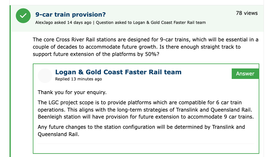
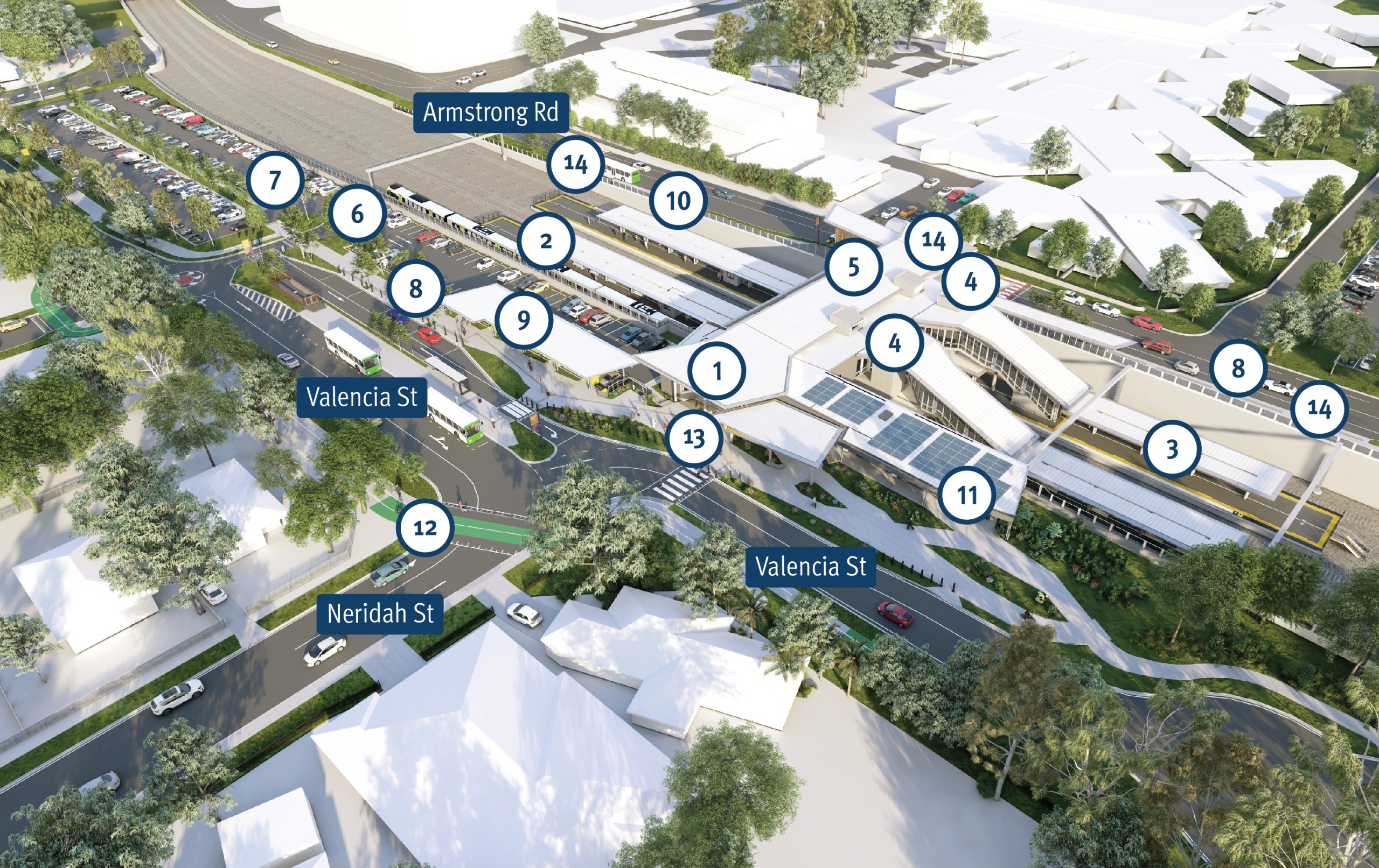
The new Loganlea station is roughly centred on Neridah St. 6 car train ~= 150m platform so it has has plenty of straight track to its west and at least based on the image they’ve left the tracks in a good spot for it too.
That was a question specifically asked about Beenleigh Station, which is why the answer was specifically about Beenleigh Station.
While I can’t find it having been put in writing, I am practically certain that Loganlea Station has been designed to allow future expansion to support 9 car trains, with the YouTube video of the station construction showing plenty of expansion space.
A work perimeter has been set up by ActivUS at Eden’s Landing. Seems like work is about to commence shortly.
Here’s a pretty informative Loganlea Station progress update from TMR’s Facebook Page.
It would indeed cause a million headaches, and may not be worth the pain now. But it absolutely should have been heavy rail in the first place. The government took the cheap option in the 90s and we’ll be paying the price for it for the next century. Short of a prohibitively expensive long tunnel, the M1/M3 corridor is the only way to get a more direct rail link from Brisbane to Beenleigh without all the twists and turns of the current Beenleigh line.
I have severe doubts it could be done with an elevated line over the M1/M3 either at this point. It’s a pipe dream until the point where the voting public cares enough to demand faster and more convenient public transport between Brisbane and the Gold Coast. I’m not sure that will happen until Brisbane hits arounds 4 million people and the Gold Coast hits around 1.2 million, which is about another 20-25 years away at current growth rates.
In Quuueeeennnsssllllaaannnnndddd, 25yr timeframe means serious planning must take place now!
I very strongly disagree with this, building the SEB as heavy rail would have been a massive mistake back when they went for it and an even mistake if done today, the areas served by it simply do not have the density to support suburban rail, and the pacific motorway dividing the area would make the densification and pedestrianisation that would be required to support heavy rail untenable. The idea of a heavy rail on the motorway only makes sense if your only goal is connecting the Gold coast to Brisbane, and while that is important the current arrangement is already comparable to driving between Boggo road and Helensvale. In my opinon a busway to heavy rail conversion would encourage even more severe urban sprawl similar to Perth, while being able to rezone the areas around a modernised Beenleigh line would help to constrain sprawl. The SEB already is the most successful public transport project in Brisbane and up there with the gold coast light rail since it opened and works very well at serving the communities it goes through, I don’t see any benefit to trying to convert it to a different mode if we really want to reorient Brisbane, Logan, and Ipswich as a whole to public transport.