Yeah, I tend to agree. In my experience, the majority of cars carrying less than 3 passengers that I see in the T3 lane are ones that are turning down a side street (it’s legal to use the T3 for a length of up to 100m to make a left hand turn).
3 Likes
Does anyone have time to work on the above Ipswich Rd numbers a bit more?
Relatedly, it might be worth building the same comparison for other key corridors where we need bus lanes- Coro Drive inbound, Old Cleveland Rd, Gympie Rd (especially the missing link at Windsor), even Logan Rd and Sir Fred Schonell Drive.
1 Like
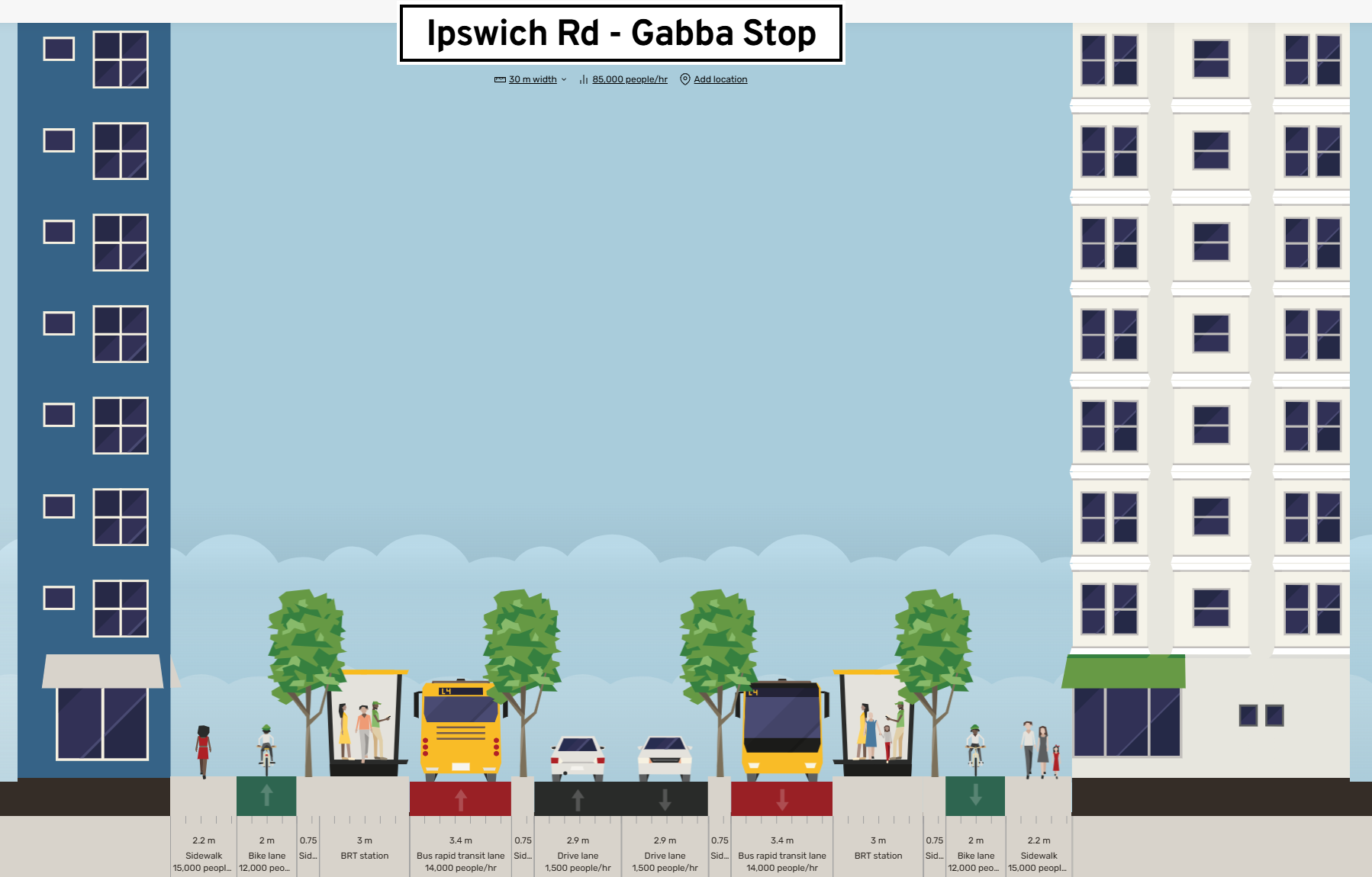
Most of Ipswich Rd is just over a 30m reservation.
Ipswich road should have bike lanes + BRT = 85k per hour
or
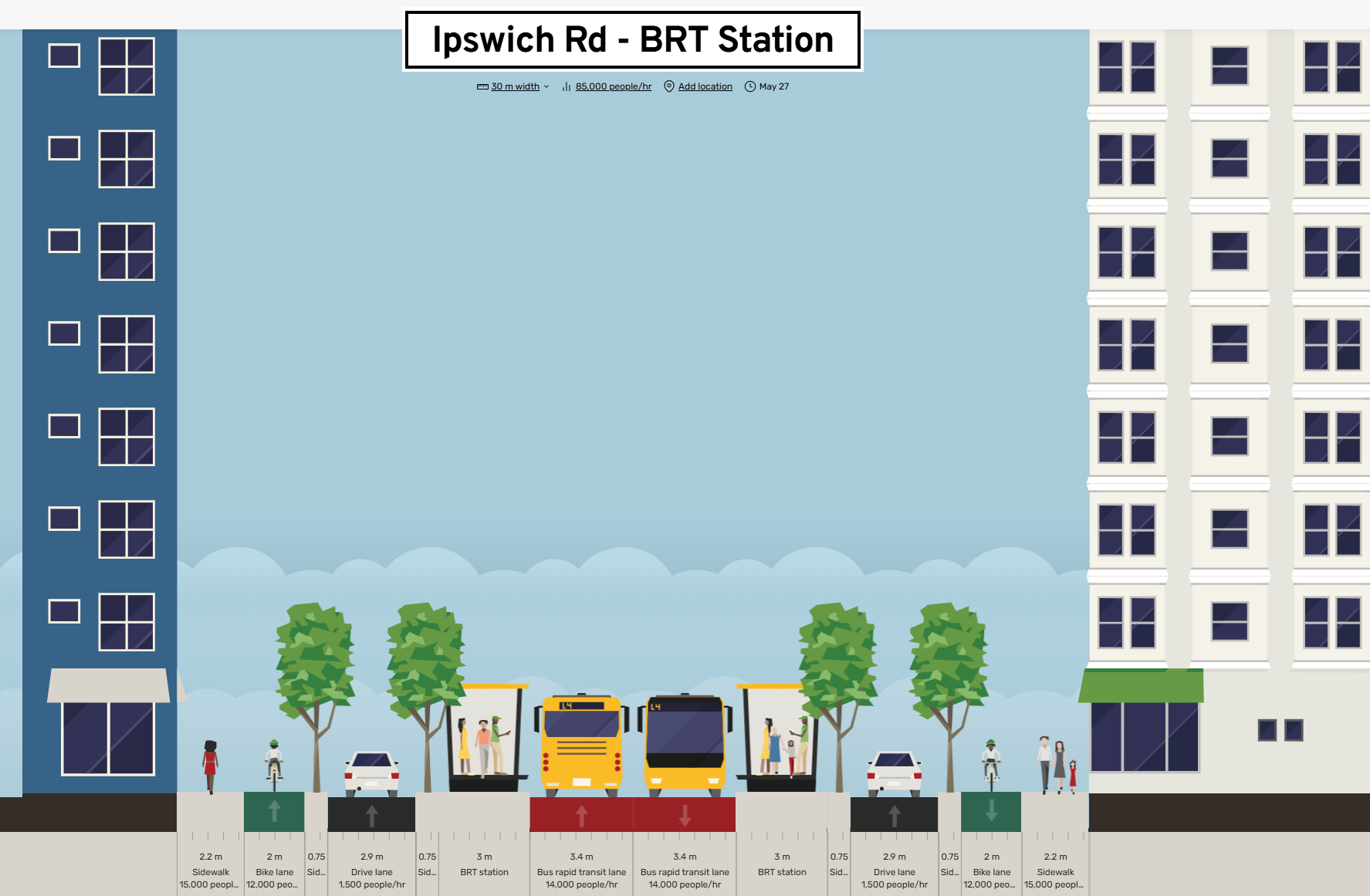
Without bike lanes capacity is reduced to only 64k/hour and limited separation of buses from general traffic.

I know which I would prefer.
4 Likes
Ignoring the fact that Ipswich Rd is an important freight corridor. Where does that fit in?
Hopefully slowly in the traffic lanes compared to the dangerous driving they typically do now.
Should the roads through our city be seen as freight corridors before they are roads people live on.
2 Likes
So what is your alternative? Rocklea, Archerfield, Acacia Ridge, Coopers Plains & Salisbury all have a lot of industrial areas. Local businesses around the Ipswich Rd corridor also need to be serviced. The reality is, Ipswich Rd is not primarily a residential street. It may have some houses facing it, but that is not its primary purpose. It is a main arterial road that carries a lot of freight. It is unrealistic to believe that can be done with 1 lane in each direction.
1 Like
I could probably do it Wednesday.
Theoretically issues 1 and 4 are solvable - you could get the total number of bus runs and subtract that from road trip count, and it would be possible (but a pain in the ass) to filter to only bus journeys that either, start, end, or pass through Ipswich road. 2 and 3 though are likely data limitations unless you can find a better dataset.
Issue 1 probably isn’t important enough to spend time on really. It could be estimated roughly just from scheduled frequencies but there are an order of magnitude more cars than buses.
For issue 4, the only hard part is converting the stop id. @Ari Do you know if there is list of stop id to either name or GPS co-ordinate?
For issue 2, do you know what the site id’s are for BCC? It says something about a “routes resourse[sic] file“ but can’t find it.
1 Like
Is today your lucky 10000 day to learn about the magic that is GTFS?
(Sorry if that’s cryptic, I’m out of the house.)
I know of GTFS but never used it. I found a .txt file with the name and GPS of each stop id here
Why? Why does it need 2 lanes? If the majority of people movement is via transit lanes/bike lane or walking why is 1 lane not enough? Deliveries are off street? Our city had become so blighted by vehicle sewers. Time to change mindset!![]()
![]()
3 Likes
I see you’ve found the GTFS stop file, which is indeed the one that you’d want. The BCC site ID comes from this additional file, but there’s only one site ID per route (Ipswich Rd is 5, so in my calculations I filtered it to that)
1 Like
I’m wondering if the footpath could be expanded into a shared bike path? That would accomodate cyclists better, and allow two lanes on the road to be turned into bus/transit lanes.
Shared paths are not better transport We Need to Talk About Shared Paths - Mobycon
“In my international work, I’ve had to adjust. I’ve learned to accept the idea and tried to understand the conditions under which shared paths might function. Now, living in Auckland and using a shared path daily, I’ve come to a my conclusions. Shared paths are mostly a bad idea, and this is why:”
Well, I read the linked article and the reasons given against shared paths were rather unconvincing IMO. For example, dogs being on the path or the presence of other pedestrians are given.
We need a range of tools to deploy in different situations and to meet competing user needs. This necessarily will involve negotiation and compromise.
Unlike other Australian states or territories, cycling on footpaths and riding scooters on them are legal in QLD and well established. So, the path just needs to be a bit wider to accomodate both pedestrians and cyclists.
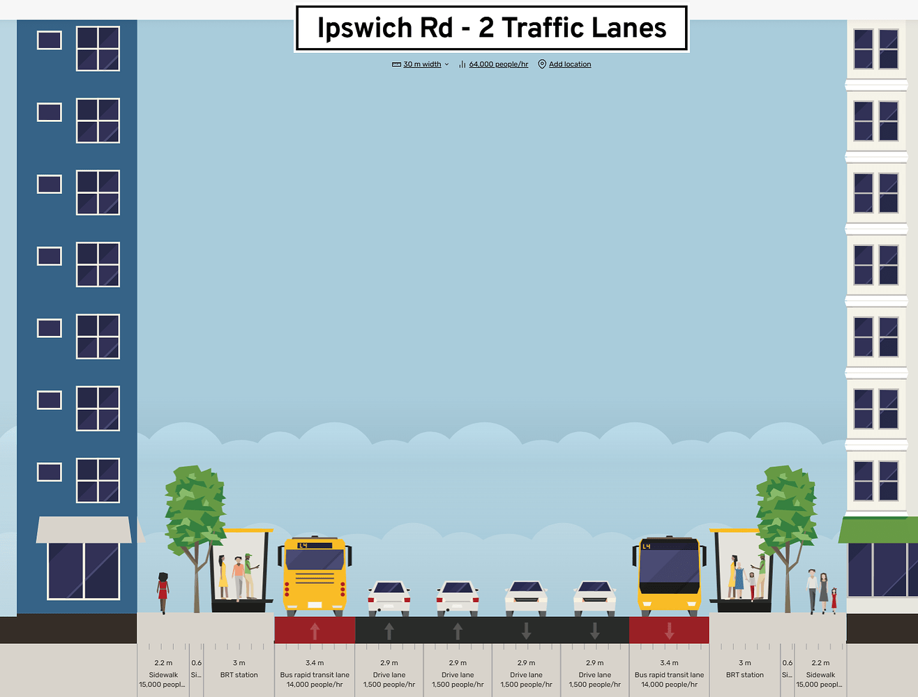
The image that shows Ipswich road being reduced to one car lane in each direction, for example, I think will attract a lot of objection. I could only really see other road corridor users agreeing to it if there were a road tunnel bypass like at Nundah.
Better to move the bike lane to the footpath and use the third lane for buses.
I would doubt that 2.9m is the correct width for general traffic lanes as well. My understanding is they should be at least 3.3m.
Gympie Road was narrowed to 3.1m to accommodate the transit way, and those lanes definitely feel too narrow for that type of road.
1 Like
We also need to chase this one up with council. I put in a submission for it a while back, as well as many others.
^^I think it should be done before the Olympics
Prefer the bus lane and bike lane proposal with one lane of general traffic in each direction.
SEQ is not going to move towards leading practice transport levels without removing car capacity. Just not going to happen. Adding capacity to our road network whilst ignoring active transport in particular for the last 50 years created today’s mess. Only adding capacity for active and public transport whilst maintaining the 50 years of road capacity will not bring the change needed.
If the public objection they need to be educated…which only the Bike User Groups and Walking Queensland seem to be doing. Govt certainly aren’t.
Plenty of cities are giving road capacity over to active and public transport and the positive outcomes are as clear as day.
3 Likes
But a shared footpath and widening it alongside Ipswich Road for cycling does add capacity for both active transport and cycling.
It just does so in a way that isn’t punitive. The third road lane can be allocated for buses.
We need a solution that works for everyone. Reducing Ipswich Road to two lanes (one in each direction) doesn’t seem like it will attract broad support, and it isn’t even necessary if you want to provide added capacity for cycling.
1 Like
I agree with this, which is why my proposal is to
- Remove the third traffic lane (or parking in that lane) in each direction where it such a lane exists, ie on much (50%+) of the corridor, replacing with a bus lane
- Remove various right turn movements or truncate existing right turn lanes to allow this to happen
- Widen the corridor or the carriageway in accordance with current Council plans to make space for bus lanes where there is no third traffic lane or space to accommodate
The first two steps can happen immediately, with the third happening as the works allow.
2 Likes
Honestly I think as important than just space is what happens at intersections - I think a good example to follow would be perhaps be either:
- Removing side street access to Ipswich road - this also improves traffic in general and allows for less conflict with transit
- For side streets that need access, maybe something like the NBB, with wombat crossings with some space to allow for cars to give way to people on the path and then to cars
- For slip lanes, ideally a wombat-style crossing (similar to side street access points as described in point 2)
- For main roads, a signalised intersection would be best
My opinion on this isn’t fully formed on this yet, so there may be some cases that I may have overlooked
4 Likes