Plenty of PPPs other than the Airport line. This is a BOOT arrangement (build, own, operate, transfer). Other PPPs have included GCLR, NGR procurement and CRR (which are based on availability payments). These are usually just accounting devices and much less odious than BOOT schemes.
Not to my knowledge. Extensive bridging works at the creeks, especially Currumbin Creek, and probably modifications to places like Lanham Street Park (the old Kirra railway culvert), but I am unaware of any part of the alignment needing to be tunnelled or substantially excavated. The unknowns associated with the engineering are why we got such a crazy range of $3.1bn to $7.6bn. The lower end of this range is not substantially different to Stage 3 on a per km basis.
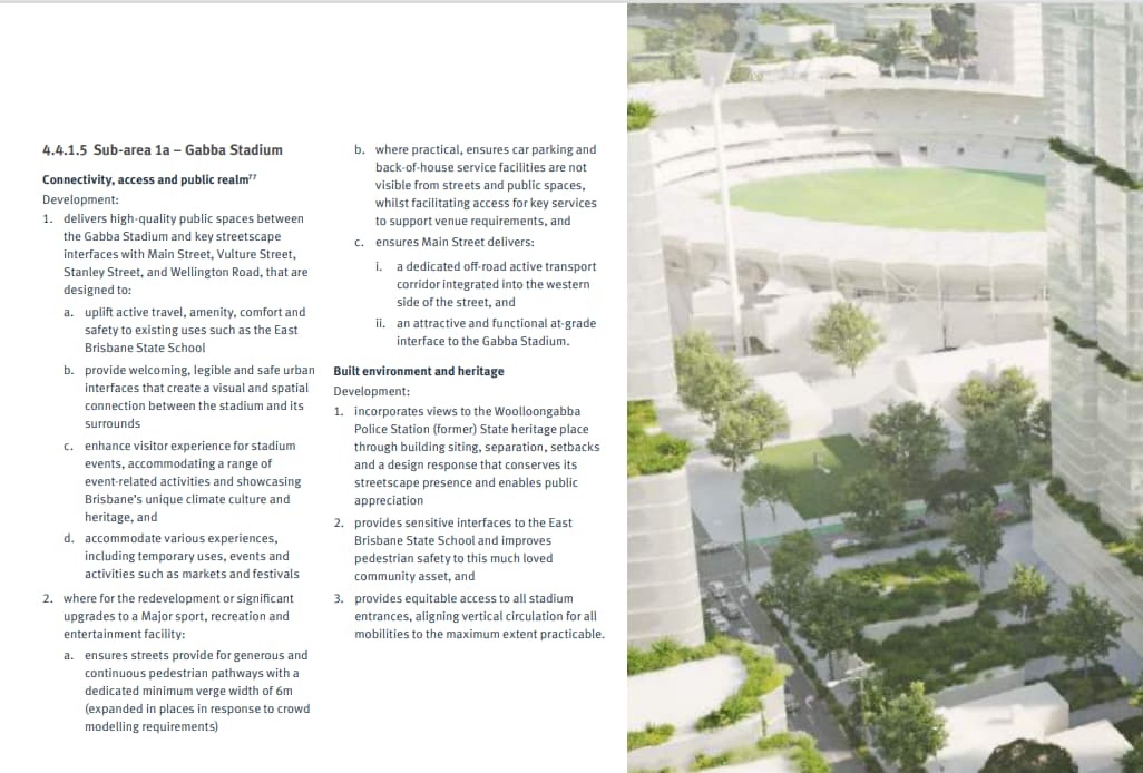
I’m still hoping that the stadium goes right over on the eastern edge of the park and Gilchrist Avenue, in which case the Ekka station and Herston busway station should both be reasonably close.
2 Likes
There was some options that involved tunnelling on Musgrave St or Tweed St. No idea if it these have been eliminated. See options K2 and K4 in the linked document.
The reference design doesn’t go that way - it uses the option everybody always assumed would be the preference (entirely on the surface via the Lanham St cutting).
The government was recently talking about how to get people in and out of the new Victoria Park stadium with public transport. I wonder if they could do a busway spur from the inner northern busway that directly services the basement of the stadium? That way they could do egress quite quickly with 6 - 12 metro buses waiting for the initial egress,. then one leaving every 30 seconds to a minute.
It wouldn’t be too expensive to do really and provide an alternative to walking to the train station at the Ekka or Roma Street.
Couldn’t they just walk from the busway stations? That would place out the very large crowds.
1 Like
It depends exactly where in Victoria Park they intend to put the stadium. Regardless, the key to servicing this stadium won’t be solved with metro. Your initial 12 metro buses will only carry 2,040 people from 63,000 and I don’t know whether you could just have 12 of them sitting there waiting for an event to finish, as you still have to run the rest of the Mx services shuttling people to all the other Olympic events being held throughout the city.
Heavy Rail is really going to be the key to moving the bulk of people to and from the stadium - a single NGR train will carry 946 pax - equal to a bit under half of those 12 metro buses.
2 Likes
The transformation of a 9ha inner-Brisbane site ahead of the 2032 Olympic Games has begun.
The Queensland Government has called for registrations of interest by developers for the Gabba entertainment and housing precinct scheme, which will redevelop the former GoPrint site and The Gabba.
A central plank of the Crisafulli Government’s 2032 Delivery Plan, the combined sites, 2km from the CBD, are connected to key public transport infrastructure, including the South East Busway and future Woolloongabba Cross River Rail Station.
With the stadium no longer on the cards, I suppose a proper high density TOD is the next best thing. I hope they’re planning on squeezing a good amount of towers into each zone, the whole PDA will have some of, if not the best access to Public Transport in QLD.
1 Like
It was always going to be high density and with no minimum car parking requirements and hopefully less car dominated streets it would certainly be transport oriented.
The eventual removal of the gabba stands and turning the space into a park where the school kids can also play will make a great inner-city high density urban environment.
6 Likes
This is indeed a big win for high-density development. Rebuilding the Gabba in its current location would have got rid of the only school around. And either more parkland would have had to be put in somewhere else, or maybe they’d have just gone ahead with the development without providing sufficient parkland. This now has a better chance of being a good place to live rather than just a place.
I doubt there will be any high density monstrosities built here.
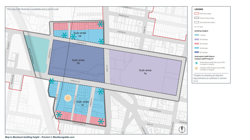
The Brisbane Live Arena is supposed to taking up all of sub-area 1b.
It is likely that sub-area 1a will be used for the school exclusively with room for modern expansions and including a proper oval. A new street bisecting the land could be added to allow for better access. There is no room for both.
Also, this area is represented by team green at BCC level, and the team red at State and Federal levels. Opposition to high-rises is a very real certainty by them and locals.
However they should also have a Plan B for this site, in case the Victoria Park stadium doesn’t go ahead.
1 Like
To be fair, the plan was to relocate the school, currently at the far western edge of the suburb, to the Coorparoo State Secondary College campus - about a 1.5km walk/drive away (just across the eastern border of the suburb). While I am pleased that the school is remaining, I don’t think that outcome would have been too terrible from a local education point of view - the secondary college site is considered to be fairly under utilised.
I think it would be a cold day in hell before the Victoria Park Stadium is dropped. There isn’t enough time to accommodate any further talk of alternatives. The Crisafulli Government’s plan is the only game in town now, for better or worse (I personally think it leans more towards the “better” side).
1 Like
By current Australian standards, this isn’t bad. However, I’m speaking in the context of Woolloongabba being developed to high density. The PDA plan had 24 000 more people projected to move into the area. Making them all trot to another suburb, adding a lot of car traffic, is not what I would have called best practice for planning a high density community. Having a school within walking distance for a child is far better from a traffic perspective.
1 Like
It wouldn’t have necessarily meant a major increase in car traffic - there is a major bus station all of a block away from the current school with half a dozen general bus routes heading east running past the Secondary College (and possibly school buses on top of that? I’m not familiar with the school bus runs in the inner city). I think a 5 minute bus trip for 50c would have been utilised over local residents driving their own vehicles.
It’s all academic now of course.
1 Like
This is a primary school, not a high school, and that does make a difference. There are a lot of parents who aren’t comfortable with children under 10 taking buses by themselves.
1 Like
There is a real opportunity to turn Woolloongabba from 2 freeway on ramps and a bridge on/off ramp into a vibrant inner-city community with the school playing a key role in that. The Gabba could also become a green heart in an area with minimal true open space. South bank is too disconnected
2 Likes
If they are planning a major redevelopment then there is a case to move the buses from the east into cut and cover tunnels from Logan Road, as well as along Stanley and Vulture streets from Lisburn Street under Mains road to the busway interchange with Cross River Rail.
2 Likes