I’d have to disagree with some of the suggestions you’ve made. Firstly I’m not convinced that there is a large enough of demand between Balmoral and Camp Hill requiring a route along that corridor.
Routes 210/212 serve different markets, there will be a requirement for Stanley Road to have access to both Cannon Hill and Carindale shops, as Stanley Road is near enough to central to both of those locations so it makes sense to have Stanley Road maintaining access to those locations
I’d rather keep the BUZ routes as is and have Routes 200, 205, 210, 212, 215 and 222 be the all day backbone of the corridor between Carindale/Cannon Hill and the City
Route 116 - I have devised some plans that I haven’t shared yet with route 116 (and the southern network in general) - I’ll be posting about that in another thread in the future.
Routes 230/232/235 in particular have been purposely omitted from this as Bulimba is a bit more tricky to service without backtracking (and I despise backtracking/doglegs in any network - to me that’s just bad network planning). During my time at TL, the ‘Godfather’ of the modern BT network (the guy who created the 1xx, 2xx, 3xx, 4xx concept and revised most of the network who was my mentor during my time at TL, gave me some suggestions at the time for that area, of which I’ll share in a separate thread)
I’d still prefer route 215 to start/terminate at Cannon HIll shops - in network planning, you generally identify key nodes and start/terminate routes where ther3e is a natural interchange point - Metroplex is not an ideal terminus and Cannon Hill is not designed to be a throughfare for buses (Routes 598/599 should be removed and separated into several routes with those routes terminating at interchanges
Again, I’m not comfortable with altering any of the BUZ routes, given they are well established and well known by users
Route 188 - I was actually toying with a route to run via Scrub Road, Mt Petrie Road, Greenway/Pine Mountain Road, then via Creek Road, Cavendish Road, Camlet St then to Garden City (as there were complaints from Camlet St residents with the loss the 172 and 184 to Garden CIty in the BNBN network and Greenway/Pine Mountain Road lacks an all day route), but decided that cross town routes like that would ideally fit in it’s own review once the separate regions networks are settled. I would’ve given it the route number 187.
I’ll now respond to what you’ve posted route by route.
Route 185 - Supported, upgrade to BUZ standards
Route 200 - I would not support any altering of this route, all BUZ routes should remain the same as is now, to reduce impacts on passengers and their familiarity with the network ie: all BUZ routes serve as the backbone of the network overall with the main changes filling in the gaps and freeing up capacity. It’s hard enough to get even minor changes given that people are creatures of habit and ultimately politics comes into hand in any network change, so messing with the BUZ routes is likely to lead to heavy political backlash making any meaningful change more difficult than it should be. Also any changes the public must be brought along with the changes, otherwise you’ll be hitting your head against a brick wall - and that comes from personal experience as a Planner in the industry. It’s hard enough to get local smaller routes altered, let along long established high frequency corridor routes.
Route 203 - Do not support it running via Gallopoli Road - too circuitous, misses out a bus stop on Old Cleveland Road that is currently serviced only by NightLink routes - again, I do not support doglegs in bus routes. Not supported to run via Deshon St, Route 200 already services this road and has established travel patterns. BUZ routes not touched to not create political backlash and cause confusion among the public.
Route 204 - I have suggested running it via Gallopoli Road to get a better catchment, service more stops than it does currently and to have a all 3 corridors properly serviced in Carina Heights (Route 200/222 Old Cleveland Road; Route 204 Donnington St/Gallopilli Road; Route 205 (Winstanley St/Chatsworth Road) as at the moment there is some duplication and an imbalance of routes servicing both Winstanley St and Gallopoli Road, the latter only serviced by 202 and 208, both being low frequency routes and only 208 heading to the city in peak)
Regarding orbital routes - I would only run orbital routes on major roads, not along smaller local streets.
Route 215 - Not supported
Route 222 - Not supported, BUZ routes should not be touched, will cause political backlash making any changes impossible
Route 232 - Again, will be posting about this in a separate thread in future
Route 211 - I would support this if given a caveat that it runs express from Crown St near Norman Park station to Shafston Ave then express to the city stops and route 210 runs in peak hour as well to continue a link to Wolloongabba). There is an aguement to be had though of which route is quicker, via Woollongabba and Captain Cook Bridge, or via Shafston Ave and the Story Bridge, the quickest route would be supported given this is peak hour and priority must be given to those heading to the city
181 - Planners would never approve of a bus doing a backtrack to a roundabout - not supported
Routes 201/206 - the reason I had designed it the way I did was to ensure that 99% of stops would continue to be serviced and the highest patronaged stops (Carina Heights (Winstanley St) and Camp Hill Marketplace would each have their own peak rocket service to reduce the demand on the 205 in peak hour which is currently getting overloaded in peak hour - from my frequent trips on it since it started), ie: 201 for Camp Hill Marketplace, 206 for Carina Heights (Winstanley St), so I would not support your suggestions.
Route 230/231/232 - I will return to this with my suggestions about this in another thread.
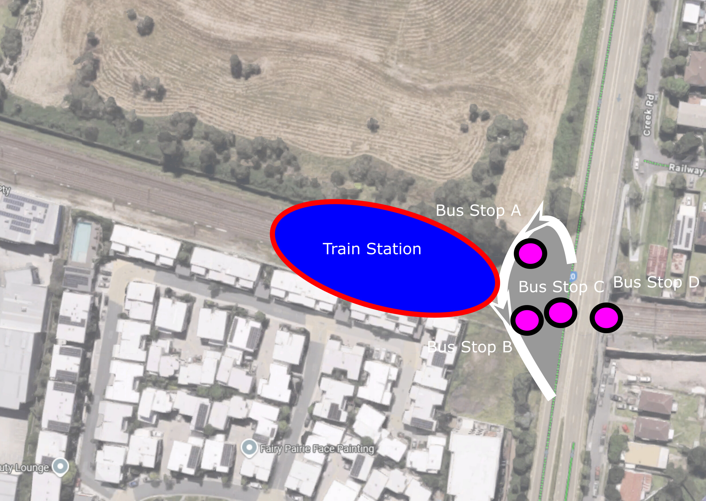
I was thinking about bus-train interchanges, especially between Cannon Hill Interchange and the Cleveland Line, and I may have an idea. I’m not sure if building it would be viable or not, but I’d figure I’d share it anyway
So the idea is a station at Creek Road (which has been thrown around), but with a bus turnback on the Creek Road bridge, so something like this:
Where Bus Stop A would service routes heading away from Cannon Hill Interchange, Bus Stop B would service routes heading to Cannon Hill Interchange, Bus Stop C would service routes heading further up Creek Road (e.g. the current 590, or the proposed 592), and Bus Stop D would service routes heading from Creek Road to Cannon Hill Interchange.
This would have the advantage of having buses terminating at Cannon Hill Interchange, while also allowing interchanging with the Cleveland Line at this new train station. Routes also would need minimal changes in order to connect here.
It does have the disadvantage of being close to 2 already established stations (Cannon Hill and Murarrie) and it not having the infrastructure built out yet (the Creek Road Bridge will have to be upgraded, and both the bus turnback and the train station would have to be built)
I’ve mentioned this in another thread that Cannon HIll and Murrarie stations aren’t really well placed for the shops and bus interchange, hence why I think it’d be a good idea in the long run to look at closing both Cannon Hill and Murrarie stations and just creating one centralised Cannon Hill station next to Creek Road as you’ve posted above. You could also then look at getting rid of the LXes at Murrarie and Cannon Hill at the same time.
Since they recently modernised Cannon Hill I would keep it. The lack of buses transfers at Cannon Hill will need to change. One to Cannon Hill shops and the other to serve Murrarie. The Barrack Rd level crossing can be closed off, people can use Creek Rd instead. Cannon Hill station can have bus services stopping at either northern or southern sides of the station.
Do not understand Brisbane’s obsession with curved stations and level crossings situated metres away from a station?
I think it’s pretty simple - that’s just how it was initially built and it costs a lot of money to bring stuff up to 100% modern design standards.
We had low platforms and lower safety standards, so the curves didn’t really matter.
As illustrated by the idea around a station at Creek Rd, you want to have stations adjacent to main roads for interchange purposes.
Grade separated crossings are expensive unless part of a necessary cutting or viaduct. Especially when the highest form of mechanisation was the steam locomotive.
Much of this land was rural. There weren’t that many trains a day and electrification was the better part of a century away.
Thanks for the detailed response. Below are my thoughts.
212/202 vs 207 | 212 vs 210
I don’t disagree with what you are saying regarding demand Camp Hill - Balmoral but as per my proposal, the route (207) isn’t there for patronage.
Given the current climate bus km/hours will likely continue to be limited and the geography of the area means that serving the current 202 (Upper Cornwall St, Buena Vista Ave), 212 (Oateson Skyline Dr) and 235 (Thynne Rd) (All of which I believe require some level of service) with radial routes results in a lot of duplication which has a high opportunity cost and makes the network that much harder to understand and use. I believe there is a lot to gain in making PT a viable alternative by focusing on simple, legible, frequent corridors rather than the status quo of everyone getting a little.
While I still believe that Stanley Rd needs a frequent route and that this should be to Carindale (rather than Cannon Hill), I agree that network I presented removing direct Cannon Hill service completely in favour of connecting between frequent routes at Carina Depot is probably going too far for how developed a connection it is.
However, I think it’s hard to justify more than an hourly coverage route if you maintain the option to connect between the frequent 210 Carindale and a frequent 590/GCL replacement. I would probably run it as Cannon Hill - Creek Rd - Stanley Rd - Oatson Skyline Dr then wherever is cheapest and has capacity to terminate it.
In previous network concepts I have had Carindale to Balmoral via Oatson Skyline Dr but I think the duplication in such a route is hard to justify in the current environment. I’ve also played with sending the inner 202 replacement south to join 172/Holland Park library area but that doesn’t accomplish much when you still need to service the Greenslopes Hospital area (Can’t re-route the 172 via Coorparoo).
200 / BUZ
While I agree that adjustments to BUZ will be controversial and should be minimised because of the disruption, I strongly disagree with completely ruling out any changes just because they are BUZ. Everything should be on the table if benefits outweigh the downside, of which change to well established route is certainly a downside. I don’t believe that the current 200 or 340 alignments are the best use of our scarce resources.
With the way the current and proposed networks fall, Old Cleveland Rd is a pretty hard line and two sides could (and I’d argue should) be done as separate consultations/reviews. The only thing that crosses the line is my proposed 207 but the status quo 202 could remain unchanged in the southern-eastern review and included in a northern-eastern review.
The southern-eastern review would come down to is there support for amalgamating the 200 to invest in all-day frequent 205 and all-day 10min 222 (I’ll do the numbers later but I think you could get 4bph 205 = 3bph 200 + 1bph 205 and 6bph 222 = 4bph 222 + 1.x-bph 200 + 0.y-bph from recycling the excessive terminus padding on 205ib, 222ob. Similarly the fat in the 202/203 timetables should cover routing the 203 via Gabba/Deshon. The 203 from 1bph to 2bph off-peak would be the next on the wishlist for this region should funding be available.
In terms of who would lose:
Carindale Heights <> OCR - Haven’t looked at numbers but I can’t imagine it’s that significant. I’m proposing to mostly keep that connection during peak with the 201 rocket and you could trial a second rocket if that is a concern. Worst case is a connection at Carindale between 4bph (Carindale Heights) and at least 6bph (likely over 10bph factoring in 204, 209) which while worse than a single seat is certainly not stranding people.
East Leagues Stop - Between 222, 61 and 204, essentially all journeys other than the category above have the Langlands Park station precinct within 300m otherwise still proposing to maintain an off-peak hourly service.
Kingfisher Stop - As above with South City Square precinct within 400m else an off-peak hourly service.
Woolloongabba - Carindale and inbound have the 204, Coorparoo and inbound the 61/rerouted 203 and connecting from the 205 at Buranda to 26 or Logan Rd buses
Bulimba
I’ll wait for your full concept before commenting too much but I have been strongly of the view for a while now that a frequent 230 deviating via Morningside station is by far the best solution for the peninsula (but how you handle Hawthorne and Thynne Rds is a lot more open).
+Gain access to the Cleveland line for new connections (e.g. Wynnum/Cleveland and Buranda)
+Gain access to the Cleveland line as an option to bypass the shocking Wynnum/Lytton Rd/East Brisbane traffic for journeys to South Bank/South Brisbane
+The area gained contains a reasonable number of trip generating businesses while the missed residential area Mile St stops remain within 400m of alternatives on the route
-Losing at most 5min
If you package the rerouting up with daytime 4bph (possible via changes to 232,235) and ideally fixing the abysmal night and weekend frequency, the community is gaining a lot for very little loss.
Murarrie
I completely agree with the principle of splitting routes at nodes (it has always heavily featured in my proposals in conjunction with trying to keep each route with clear non-conflicting roles) and believe that Cannon Hill especially is a natural location to split routes due to the gap in density to the east.
However, I disagree that the Cannon Hill is intrinsically designed to not be a thoroughfare and thus by inference that all routes must be split at Cannon Hill. I don’t see any issues with routes approaching Cannon Hill from the south throughrunning (Wynnum Rd throughrunning is clearly sub-optimal hence the status-quo with routes 216, 221, 227), so long as the route role remains consistent. From a layover perspective the current design (and to a lesser extent that proposed redevelopment) certainly lack the capacity for extensive volumes of terminating buses.
On Metroplex specifically, I would like to see stops installed on Lytton Rd just east of Creek Rd and the 590 deviation removed (as they managed to do on a temporary basis while the COVID testing site was set-up there) which I imagine you would also support. However, my proposal was as presented as there are three areas north of Cannon Hill to cover (Queensport Rd, Creek Rd and Barrack Rd) and only two obvious through routes (232 towards Bulimba and 590/GCL merge over the Gateway). You either need to make one of the two circuitous, add a 2nd route in either of these directions or extend a route to terminate here. I wanted to avoid the first option and don’t believe there is the budget for the second option which left the third option by default.
I think Brisbane could and should significantly improve industrial commuter services beyond the current and pretty average 302/303 (and 299 if you count the Eight Mile Plains Tech Park) and maybe the solution is a Cannon Hill - Apollo Rd shuttle via Lytton and Queensport Rd or a more Eagle Farm/Aviation focused secondary version of the 590 while the main cross-town focuses on Skygate but in either case peak service is going to be a battle let alone off-peak.
I note you do propose Murarrie station as a transfer point to/from the east which if it can be supported (both bus and ideally 4tph or better) would do a lot of good for both Murarrie and the wider network.
Carina Heights (and Camp Hill)
A lot of our differences here seem to come back to route roles.
I agree that there are three main corridors as you’ve identified (OCR, Winstanley And Gallipoli/Donnington). The first two are clear cut (222 and 205) but the third I would argue is more minor and ambiguous. For its size, the northern part of Gallipoli is well serviced and gets what it gets due to the low opportunity cost of serving it as it’s essentially on the way to Carindale with minimal time penalty while gaining catchment (especially OB versus the Bedivere St bridge loop). The southern section of Gallipoli (and onto Donnington) is what I call circuitous and a deviation while serving a relatively small catchment (Given overlaps with the Creek Rd and Winstanley St corridors). Having ridden this ‘loop’ many times on the 202 over the years, while it probably only adds 3min or so, it feels like you are going well out of the way and very rarely actually service any passengers on southern Gallipoli.
To me, the 204 is currently a trunk all-stops route, its slow from a tight stopping pattern but it doesn’t significantly deviate. Moving the 204 from Gallipoli-Winstanley to Gallipoli-Donnington would blur the route into a more local coverage role and dissuade through travel which I think it would be to its detriment, especially given the Clem Jones extension outbound of Carindale (Easier said then done but this is something I’d like to see split from the 204). Despite this, I think southern Gallipoli should be linked with northern Gallipoli, just not on the 204. Instead, I see this as the role of the 202 and 203. These routes are inherently local and especially now following the introduction of the all-day 205, should focus on providing coverage to those who can’t access the 222 or 205 (and to a lesser extent the 204). Right now they are too slow to be anyone’s first preference but also don’t fully cover the area.
In my view, having lots of slightly different routes only a block or so apart is not an effective network design. It increases complexity without delivering meaningful additional coverage. While you can’t leave people out (hence the need for adequate coverage), you need legibility (which comes via simplicity) and frequency to make public transport really viable and attractive.
You end up with cases where you go:
xx:06 local by walking 3min west
xx:11 or xx:16 local by walking 6min east
xx:22 or xx:52 regular by walking 6min west
xx:26 express by walking 10min west
You shouldn’t need to be doing down-to-the-minute scheduling to work out which stop to head to (Before even adding in real-time variations).
For these reasons, I don’t believe there should be multiple local routings between Boundary Rd and Carindale outside of what is forced by the road layout (I would like to see a solution to allow Samuel St to ideally Martha St but alternatively Newman Ave in both directions - potentially signalise Boundary-Newman?)
Admittedly, the majority of my BNBN 205 trips tend to be shoulder peak, but even when I have travelled in peak, while busy, I’ve never observed any significant standing loads on the 205 and all trips seem to be now operated by rigid buses (Often tags were used on the P205 pre-BNBN). In any case, I see addressing this as the role of the 208 (as an inner peak sweeper). I imagine you wouldn’t have supported it but I had advocated in the original pre-BNBN current route feedback request for 208 truncation (I believe to Boundary Rd) as the demand is all inner section with the then P205 and P206 covering the outer portion.
I wasn’t explicitly trying to keep all stops serviced by rockets the same which will explain some of our differences.
206 north of Carindale - I would argue with a 210 Carindale frequent route that it is not required
206 Donnington - Currently removed given proximity to either Carindale, 205 or my 201 via Pine Mountain-Gallipoli but you could extend 217 or similar if deemed important
201 - Currently removed as I wasn’t supportive of adding a rocket through Leicester St in BNBN but if patronage is there (and I recognise I’m currently rerouting 203 away from Buranda again which strengthens the case) keep as per current with more stops. This would also help address my proposed 200 removal.
Proposal aspects not covered
As I haven’t directly responded to your map a few comments:
207 - Concerned about the usefulness of the inner 207 alignment which to me feels like the worst of both worlds - you lose the pre-BNBN single seat to City while also losing any timely way to transfer to the City making for a very niche route. Sticking to the current alignment gives combined frequency with the 208 for those who need to transfer at Buranda anyway or are happy to change for a faster trip. Going via Buranda would also help with your 205 crowding concerns. Buranda also gives high frequency onwards connections to PAH, Boggo and UQ Lakes in addition to the route itself continuing to the southern part of the hospital, Buranda shops and Dutton Park station.
210/211 - Other than reducing change, is there any reason to keep these routes on Perth St/Mcilwraith Ave rather than Macrossan Ave which seems significantly more suitable for running through bus services.
Other Comments
I disagree with it being that black and white. While not to say all of these are good design, there’s certainly no lack of routes in Brisbane with similar or worse deviations. I’ve put together this list from a quick skim.
Minor on road deviations: 100 Forest Lakes, 45x Sumners Rd at Riverhills East, 367 McGregor Way, 101 Wallaroo Way, 590 Metroplex, 471 Stuartholme College, 302 Schneider Rd, 306 before Nudgee Beach extension, 358 Aveo Albany Creek
“Off-road” deviations: 45x Sinnamon Village, 412/N413 UQ Chancellor’s Place, 362 Great Western Shopping Centre, 354 Prince Charles, 590 Skygate
Larger deviations: 430/445 Lone Pine, 326 Sandgate, 101 Richlands, 192 UQ, 358 Eatons Hill/Albany Creek, 350 Albany Creek night
I think the key thing is keep these to a minimum and they should be near the end of the route to minimise the number of impacted passengers.
I’ve proposed this on two Carindale Heights routes (due to the poor estate design); route 205 (Scrub Rd south before Cribb Rd ~3/4min) and 181 (Scrub Rd central before Greendale Way ~2min) which in both cases add minimal additional travel time which only applies to the handful of passengers going to the 2 suburban stops between the deviation and terminus.
Don’t want to steer too far from the focus here on the east but I completely agree that Camlet St is one of the few areas that really is significantly and objectively worse off under BNBN:
off-peak: from 3 routes (113, 172, 184) to 2 routes (113, 172) without frequency improvements
peak: losing their rocket (P173) without real frequency improvements