Brisbane East Network Suggestions

As some of you might know, I’m gradually going through the entire Brisbane network (not the outer regional networks), and looking on improving what we got out of the BNBN project in order to create a trunk and feeder network and better connections with key locations and railway stations.

To start, here’s the Brisbane East network I’ve put together.

Summary as follows:

Changed Routes 201, 203, 204, 206, 208, 214, 215, 220, 223, 224, 225, 227

Removed routes 202, 213, 228 (Cannon Hill to City express)

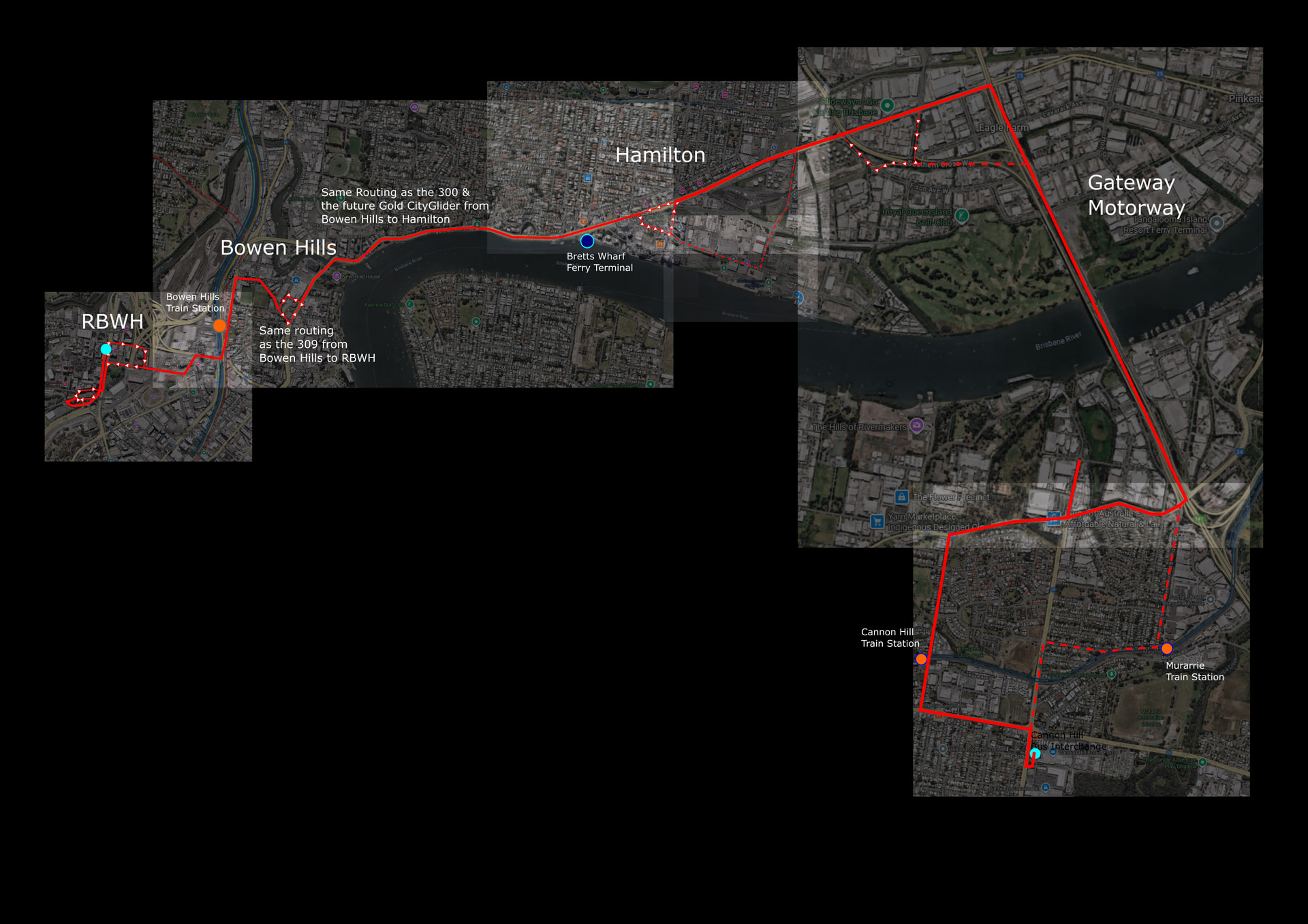
New routes - 207, 226, 228

Routes not considered in this network (will review separately) - 230, 231, 232, 235, 236

Unchanged routes 200, 205, 209, 210, 211, 212, 216, 217, 221, 222

Route descriptions:

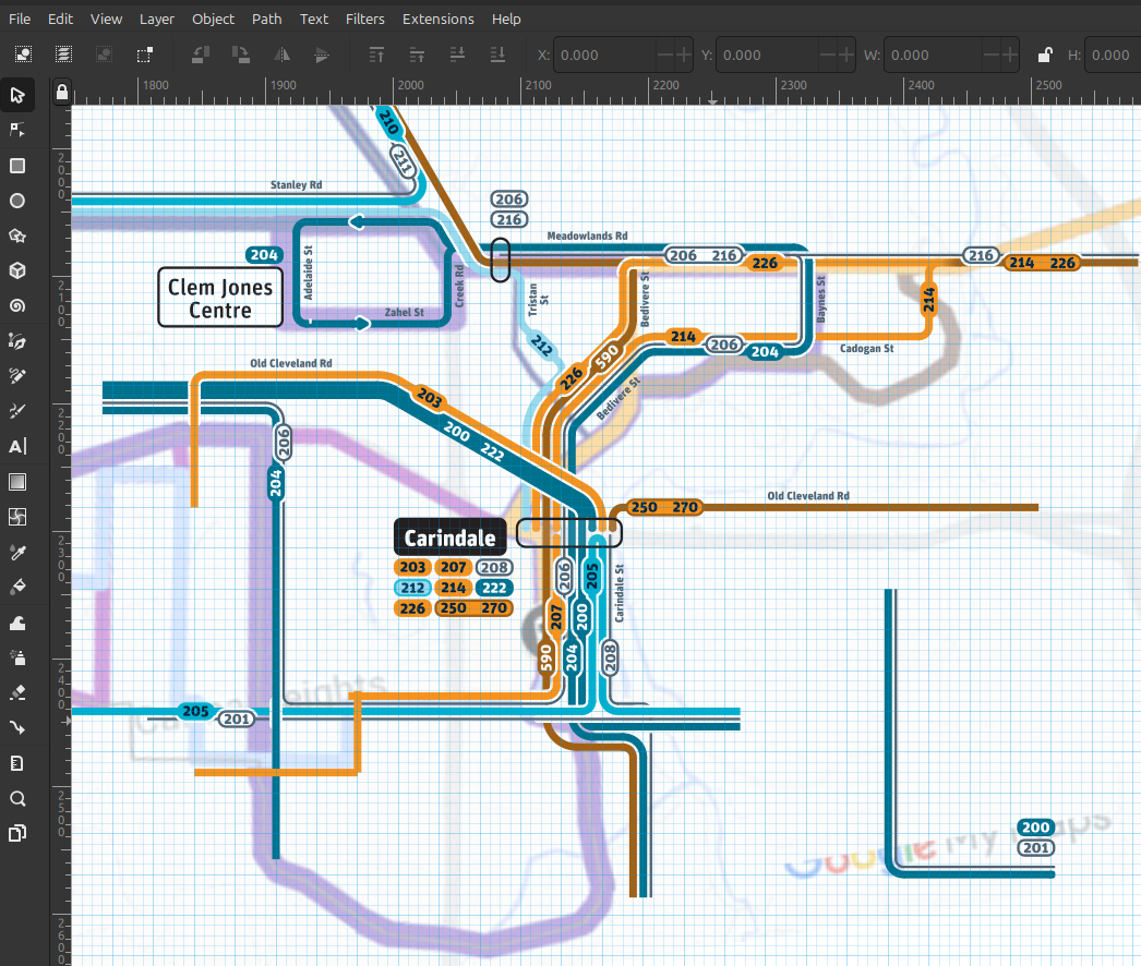
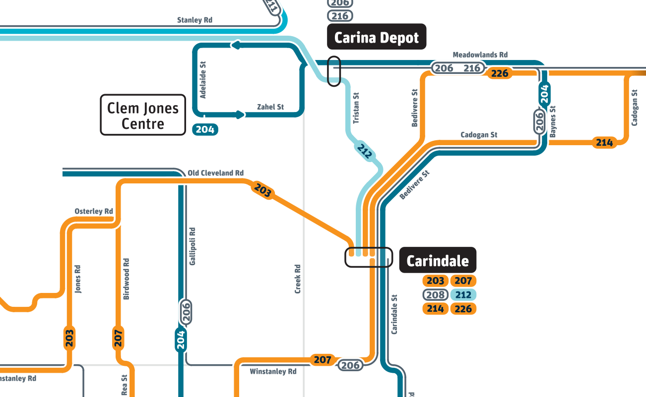
Route 201 - Carindale Heights to Brisbane City (Rocket)

Route 203 - Carindale to Boggo Road Station via Carina Heights and Camp Hill

Route 204 - Carina/Carindale to Fortitude Valley via Captain Cook Bridge

Route 206 - Carina to Brisbane City (Rocket)

Route 207 - Carindale to PA Hospital Station via Carina Heights and Chatsworth Road

Route 208 - Carindale to Brisbane City via Carina Heights and Camp Hill (Express)

Route 214 - Carindale to Cannon Hill via Belmont and Murrarie

Route 215 - Cannon Hill to Brisbane City (High Frequency)

Route 220 - Wynnum to Cannon Hill via Murrarie

Route 223 - Lindum Station to Manly Station via Wynnum Plaza

Route 224 - Wynnum Plaza to Manly Station via Wynnum Central

Route 225 - Cannon Hill to Brisbane City via Wynnum Road

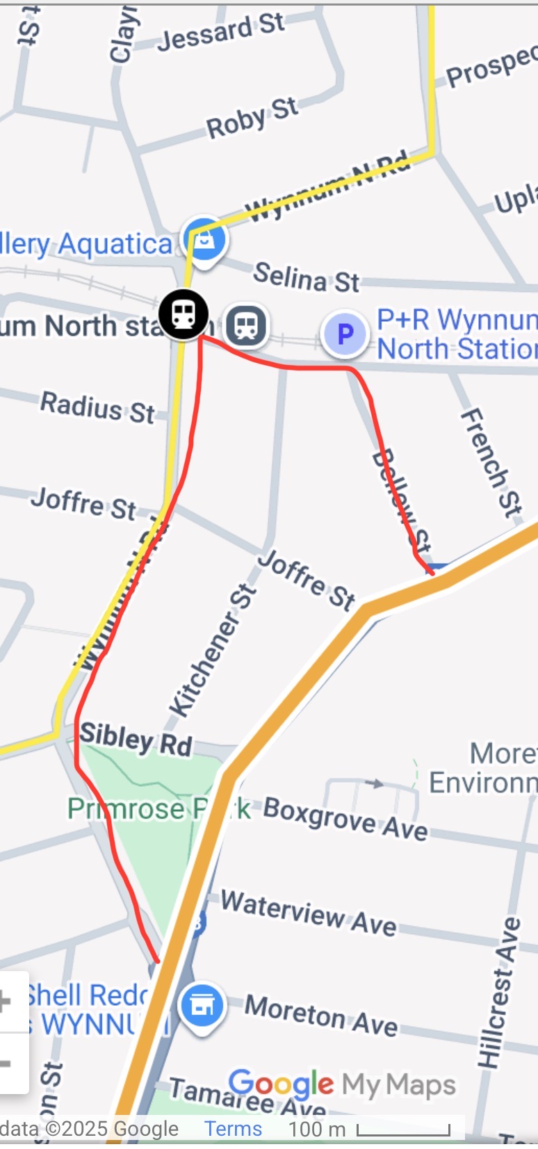
Route 226 - Carindale to Wynnum

Route 227 - Wynnum to Cannon Hill

Route 228 - Wynnum Plaza to Hemmant

Route N229 - Renumbered Route N226 (still the same route)

Feedback would be appreciated - you can see the map here - Brisbane East Network Proposal

EDIT: Just to make it clear - Route 201 only has a minor change and uses Thomas Street outbound in Camp Hill, with a new stop created at Samuel St near Thomas St, Route 201 would now also stop at Camp Hill Marketplace in both directions, rather than skipping it as it does now, which will help with the current heavy loading of route 205. I would also recommend that route 205 runs every 30mins Monday to Friday and hourly weekend services introduced.

Route 203 would also use Thomas St outbound, as the turn from Boundary Road to Samuel Stret outbound is too tight for a bus.

3 Likes

How feasible would pulse timetabling be at some interchanges (such as Wynnum Plaza)?

1 Like

Should be feasible, there are two bus stop spots on one side, and one bus stop spot on the other, which could easily be expanded to two if the taxi zone was moved.

4 Likes

Just some indicative frequencies:

215 - every 10mins peak; 15mins off peak; 30mins after 7pm - operate 7 days a week

225 - every 15mins peak; every 30mins off peak; every 60mins after 7pm - operate 7 days a week

all local routes (223, 224, 228) - every 30mins peak, every 60mins off peak - operate 7 days a week

all crosstown routes (203, 207, 214, 220, 226, 227) - every 15mins peak; every 30mins off peak; every 60mins at night - operate 7 days a week

The 204 would continue to operate at the same frequency as it does now.

Peak routes would ideally operate every 10mins or better. (the current 208 only operates every 20mins, which isn’t ideal to capturing time constrained pax like city workers).

Ideally you’d want to meet every train for every route, but I don’t think any budget TL could get up would cover that, so the next best thing is to cover when most people travel.

I’m currently going through the potential impacts to the interchanges (Cannon Hill; Wynnum), and will get back to this thread later about that.

2 Likes

I think the goal should be to have the 205, 210 and 215 run at similar standards. (And retimetable the 200 and 222 to even out the headways, and have both routes stop at all the same stops between Coorparoo and Carina.)

5 Likes

Could the 220/221/226 have a connection to Wynnum North Station? I think deviating from Wynnum Rd by going to Wynnum N Rd→Cameron Pde→Bellew St back to Wynnum Rd could work, with a stop at Cameron Pde to connect with the station. Something like the red line below:

EDIT: another possibility could be going via French street

The connection the Murarrie you presented on the map is something I would also vouch for, as it is a relatively simple deviation and it adds for an easier connection to the train line

1 Like

ive also been brain storming routes across the city a little bit

3 Likes

I was taking a look at the Wynnum Plaza Interchange, looks like buses heading to/from the West (e.g. on your map, that would be the 224 and 228 and others) don’t have a good point to turn around - this isn’t true for buses heading to/from the east (they can use the roundabout west of the interchange). This, however, shouldn’t be an issue from my understanding, as outbound 227’s could turn into Manly-bound 224’s and Hemmant-bound 228’s, and vice-versa. Given the frequency, this should work, as when the 224 & 228 are active, their frequencies are half that of the 227.

Another thought: would it be possible for TransLink to route the 214, 216 and 226 along Loughrea St instead of Castlerea, making those routes a little more direct? The eastern side of Castlerea St is mostly parklands. [Edited to add:] How about the 214 using Breadsell St for the same reason?

(By the way, Wynnum station doesn’t get much patronage, does it? It seems like a station that could be closed, given that it’s within spitting distance of Wynnum Central.)

5 Likes

Hi STB,

As a 20x local myself, I’ve also been playing with various eastern network concepts (Mainly for west of the Gateway) over the years.

I’ve cleaned up my most recent concept which can be found here: Pionsix Eastern Network – Google My Maps

Notable Concepts:

Gabba local terminus from East (All non-frequent routes)

  • IB: Service Woolloongaba station then exit via Allen St portal then Stanley St, Annerley Rd then enter busway and service Boggo Rd station then terminate PA Hospital station lower level
  • OB: Service PA Hospital platform then Boggo Rd station then exit onto Annerley Rd, Stanley St then enter busway via Allen St portal then service Woolloongabba
  • Removes right turn movements required if travelling northbound from PA Hospital to Gabba.
  • Keeps South Bank/Mater Hill busway section as only frequent routes improving capacity usage and legibility.
  • Route 116 truncated back to PA Hospital rather than service inner-Annerley Rd

Bulimba:

  • Riding Rd routes to travel via Pashen St and Thynne Rd to service Morningside station
  • Hawthorne Rd route should be via Gabba (Given proximity to CityCat for northern CBD)
  • Riding Rd - City route (if present - not on map - see route 202/212/235 section) should be via Story Bridge
  • Only local routes via Heidelberg St. Major routes via Wellington Rd/Latrobe St.

Cannon Hill - Cleveland Line connection:

  • Route 592 (Current 590) should service Cannon Hill station and not deviate into Metroplex
  • Route 215 (Current 214) to operate full time and service current GCL path then terminate Metroplex
  • Route 232 rerouted to cover northern Creek Rd

Carindale Heights to City:

  • Merge route 200 (West of Carindale) with route 205 (East of Carindale) but via South Bank
  • Ideally introduce new all-day local (Route 188 - Carindale to Griffith Uni via Carindale Heights, Mansfield, Mackenzie, Rochedale, Eight Mile Plains) to cover southern Scrub Rd. Alternatively, have new route 200 loop via southern Scrub Rd prior to terminating at Cribb Rd (As shown on map).
  • Increase route 222 to every 10min (6bph) to recover lost OCR capacity. Weekends should be HCV rather than rigids.
  • 209/222 to get additional stops at St Leonards, Kismet St (209), Orwell St, Gallipoli Rd.
  • Reroute route 203 via Deshon St then via Woolloongabba station and Annerley Rd to PA Hospital (See “Gabba local terminus from East” section).

Stanley Rd:

  • Merge Route 210/212 into a high frequency route Carindale - City. Creek Rd (210 section) no longer maintains an all-day connection to City but Route 211 provides peak.
  • See section on 202/212/235, if this is not possible then reinstate route 212 running current route until Creek Rd then terminating at Cannon Hill

Routes 202/212/235:

  • These corridors are all complex/expensive to service due to geographic bottlenecks nessessitating duplication on radial routes (202 corridoor disappears due to Whites Hill, 212 due to Seven Hills, 235 due to river.
  • Propose running local orbital route (Current 202 then via Boundary Rd then via Seven Hills (212) then via Morningside station to Thynne Rd (235).
  • This is expected (Calculations yet to be done) to maintain coverage at a lower operating cost allowing resources to be put into improved 210 frequency.

All-day routes removed:

  • 202 (Merged into 207)
  • 205 (Merged into route 200)
  • 212 (Merged into 207, 210)
  • 214 (Renumbered into 215 replacing inner 214, 220)
  • 235 (Merged into 207, 230, 232)

Peak Routes removed:

  • 206 (Merged into 201)
  • 228 (Merged into 227 truncated)
  • 236 (Merged into 207, 230, 231)

All-day Route Overview:
61:

  • No change

185:

  • Work towards BUZ standard.

200 [200/205]:

  • See Carindale Heights section.
  • Follows route 200 (West of Carindale), route 205 (East of Carindale) then via South Bank.

203:

  • See Carindale Heights section, Gabba local terminus section
  • Service Old Cleveland Rd at Carina if possible. Run via Gallipoli/Donnington loop.
  • Terminates at PA Hospital via Annerley Rd and Woolloongabba. Service Deshon St in place of 200.

204:

  • Run via Langlands busway (Could run via Deshon St)
  • Option to slightly reduce frequency (3bph) if required to fund other routes

209:

  • No change

210 [210/212]:

  • See Stanley Rd section
  • Merge 210/212 into all-day frequent if possible Carindale to City route

207 [202/212/235]:

  • See Routes 202/212/235 section
  • Create new orbital local route to reduce operating costs while maintaining coverage.

215 [214/215]:

  • See Gabba local terminus section.
  • Proposed to terminates at PA Hospital via Annerley Rd and Woolloongabba. Could be sent via Captain Cook Bridge if higher frequency.
  • Extended to Metroplex via Murrarie station
  • Replaces inner 214/215/220.

222:

  • See Carindale Heights to City.
  • Increased to 6bph and weekend HCV
  • Add additional stops

227:

  • Truncate to Cannon Hill?

230:

  • See Bulimba section
  • Upgrade to high frequency, run via Morningside station

232 [232/235]:

  • See Cannon Hill - Cleveland Line connection section, Gabba local terminus section.

590:

  • 590/GCL merge south of Carindale with Sunnybank Hills extension

592:

  • See Cannon Hill - Cleveland Line connection section
  • 590/GCL merge north of Carindale with Aspley extension
  • Services Cannon Hill station and removes Metroplex deviation.

Peak Routes:
181:

  • Loop via Cribb Rd roundabout

201 [201/205/206]:

  • Operate 206 to Creek Rd then via Pine Mountain Rd to Scrub Rd south terminus

208:

  • No change.
  • Maintain Jones Rd roundabout terminus to reduce duplicate/blank running

211:

  • Option to run via Story Bridge via Norman Ave

217:

  • Extend from Carindale to Carina Depot

231:

  • Route via Morningside station as per revised route 230
3 Likes

Is the Google Maps link adequate for an MR? Turning it into a schematic could take ages (esp. if including the 200, 205, 222 etc).

5 Likes

It would be adequate enough, although having a schematic would help a lot. Doesn’t have to have all the routes on it though.

1 Like

A bit out of the scope but the 270 should have a frequency increase to at least half hourly to connect with all ferry services at Victoria Point.

For the 250… The route takes absolutely forever to do in its current form, so I’d highly advocate to split it in two.

  • 250: Carindale Interchange - Toondah Harbour via Cleveland station
  • 260: Redland Bay, Shoreline Ave - Toondah Harbour via Marina and Victoria Point

If possible, make both run every 15-20 minutes.

1 Like

Simpler without those extra routes, I must say.

3 Likes

Can we have route 222 extended to the Sleeman Centre.

2 Likes

Are we advocating or proposing alternatives to the E Busway expansion as part of the East network?

Does Old Cleveland Rd still need bus-only lanes? Should they be expanded to Capalaba still?

Should the 61 Maroon Glider be extended to Carindale from Cooparoo Central?

Honestly the 61 should just be merged with the 200 with the latter being extended to either Ashgrove or Bardon.

If they merged the 61 and 200 would it follow

  1. Deshon St and Main Ave (the existing 200 route)
  2. Logan Rd (the existing 60 route)
  3. Would it terminate at Carindale shopping centre or go all the way to Cribb Rd.

This is a half-north side, half-east side one, but I think it still fits

I think a route between Hamilton and Cannon Hill could be quite useful, as all of the connections north of the gateway go northwards

Inbound of Hamilton, I’m not sure what path it could take exactly. It could do a turnaround at Hamilton, similar to 304, or a turnaround at Doomben Station, similar to what the 303 does, or head to Nudgee Road towards Toombul, or do what’s suggested with the map and head to RBWH (though this would parallel quite a few routes)

3 Likes