It would be an interesting discussion exercise to consider additional Ferry terminal locations or how the stopping pattern can be optimised. It would also be interesting because it forms a clear basis for a policy that could be taken to a BCC Council election.
Compared to other transport modes, ferries have high operating costs, however, unlike a busway or a railway, you are not paying to acquire or maintain the corridor. Mostly the terminals and riverbank nearby. This makes it very attractive for investment.
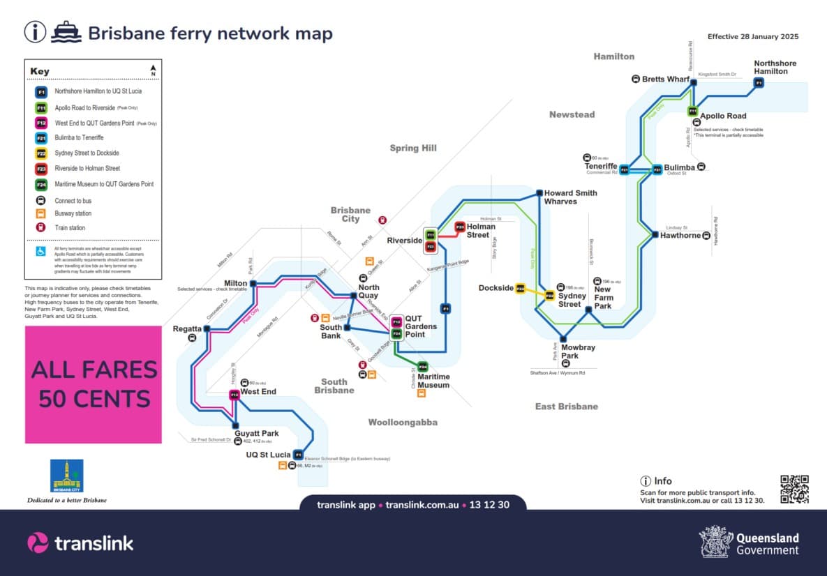
Potential New Terminals for Discussion
Long Pocket - Handel Street Park
Yeronga - Orlando Road
West End - In the vicinity of Rogers St
West End - In the vicinity of Jane St
Norman Park - Near Norman Avenue
Murrarie - Near Metropex Avenue (could come with P&R, extend the local bus to meet the ferry)
Any others?
The inner part of the Ferry network could get an inner-stops only supplementary service to service higher demand in the inner section of the network.
Previous attempts to expand the ferry network upstream or downstream have generally met with objections on financial or efficiency grounds (e.g. faster to get to the CBD or other destination by bus), but each location should be assessed case-by-case.
Not sure about Norman Park. The cross-river ferry that used to operate there got barely one passenger per service. Not sure that is a sensible use of the fleet. Also not sure Rogers St makes a lot of sense, considering it will be in fairly close proximity to the future Toowong to West End Green Bridge.
I could agree with Long Pocket an Yeronga, but think that should be the further upstream CityCats should go, purely for ecological reasons. I also think motorised recreational vessels should be banned upstream of Long Pocket, but that’s a separate discussion.
I also think it is time to introduce a two-tiered service. Northshore to New Farm Park, then express to Riverside, South Bank, North Quay, Toowong and then all to UQ.
Then a separate New Farm to Toowong all stops service.
This would of course require a lot more vessels. Unlikely BCC will budget for that many Cats, so it’s probably a moot point.
Even extension to Long Pocket an Murrarie will likely require more vessels. Also, is there any expectation of patronage to/from Metroplex Ave outside of peak hours? Maybe also a peak-hours only extension to Holt St, Pinkenba, and extending the 302 bus to meet the CityCat.
Whether the current express service actually adds value beyond the “Express” label needs to be looked at.
Express services save time by making other users wait at the ferry terminal (as the service bypasses them). So we need to compare the time saved for those on board versus the reduction in waiting time that an increased frequency would bring by just having an additional usual service.
You are right that new terminals and ferries cost money, but again, this is comparatively less than say a busway or a railway where you have to pay for both ROW and stations.
Also, is there any expectation of patronage to/from Metroplex Ave outside of peak hours? Maybe also a peak-hours only extension to Holt St, Pinkenba, and extending the 302 bus to meet the CityCat.
Peak only extensions are an interesting idea worth exploring further.
Metroplex is a bit of a gap, it is partially served by Route 590 (half-hourly service). This could be extended a bit further to meet the proposed Ferry.
I have been through Metroplex a few times during off-peak hours, mostly nights and weekends, and I’ve never seen a single passenger embark or disembark there at those times. There are quite few on weekday mornings and afternoons, though. The other thing is that the peak-hour extensions would only make sense in the away-from-city direction. I don’t think too many people will be travelling to Pinkenba or Metroplex at 4 pm.
Regarding express running, I had a CityCat captain tell me a couple of years ago that the current operation was literally destroying the engines, as they weren’t designed to do as much stopping and starting as they do. Probably what’s required is short-distance CityCats geared for faster acceleration and lower top speed for the inner-city sections. Once again, though, dollars would be the determining factor.
Another thing I would like to see investigated is if some of the busier pontoons (South Bank, Riverside, New Farm Park) could be extended to permit both front and rear boarding. Not sure how this would work with current safety procedures, but there are generally two deckhands on each boat, so I wonder if they could each supervise one entry?
Potentially, though there are a few offices in that pocket, there is a BCC park there and it could be connected to the wider network through the 590 meeting it, which would open up a few more travel possibilities that cross the Brisbane River.
Stops or stations at the end of a line tend to be a bit quieter, and that is not unusual.
Another thing to be aware of is that there are a couple major obstacles preventing CityCats heading upstream from UQ. From memory there’s a large rock bank just under the surface directly upstream of the bridge which would pose a serious safety risk to anything larger than a dinghy - not sure if this could be steered around with the help of some buoys or if it’d need to be removed.
IIRC previous studies also showed significant erosion risk + environmental impacts from large vessels upstream, which would also need to be considered for any service expansion
There’s the more fundamental issue that given the bends in the river, the route is too slow to be competitive with anything upriver of UQ for a trip to the CBD. The main benefit would be cross-river connectivity.
If it was technically feasible I think the absolute limit for up-river operations would be King Arthur Terrace - stops from there to UQ maybe at Long Pocket (north bank) and Brisbane Corso (south bank), maybe another one in between Long Pocket and Brisbane Corso.
For downriver, I think there are at most 3 feasible extensions
All of these I think are going to be more marginal than the upriver extensions in terms of take-up. These places are basically dead most of the time and have zero or practically zero walkable residential catchment, which is consistent with these places being industrial / shipping territory, and getting people into these places by any means (walking, cycling, by bus, park and ride or otherwise) generally means a detour to get there and additional travel time on the ferry to get anywhere.
This is interesting, because (as far as I am aware) the route is generally the same today as when it was first conceived 30 years ago. They really only added 4 new stops (Milton, HSW, Teneriffe and Northshore) to the route since I was riding it as a kid.
Also Apollo Rd & Toowong, and the thing with most of those stops is they are quite close to others (Apollo Rd/Bretts Wharf, Teneriffe/Bulimba, HSW/Riverside, Milton/Toowong & North Quay. The only one that really stands out as being some distance is Toowong (Regatta), which is a fair way from West End.
I’m not a mechanical expert, but the essence of what he was saying was that some marine engines are designed to run more at speed and less acceleration, and others are the opposite.
Toowong was on the route when I was a kid so I didn’t realise it wasn’t an original stop. I also didn’t know that Brett’s Wharf to Apollo Road was only a cross river ferry back then.
Even still, it’s weird to me that they wouldn’t get boats designed for reasonably frequent stopping, particularly given they’ve had multiple generations of boats.