A bus, bike and walking bridge from Bulimba to Teneriffe would pretty drastically improve public transport in the eastern suburbs.
It would take serious pressure off Wynnum Rd, and create some very cool cross-suburban connections. As the Bulimba Barracks and Colmslie developments get built there will be more people living in the east who will almost certainly all drive to get around unless PT improves a lot.
It might not be as high priority as some others, but I think it’s fun to dream..
The major constraint is a requirement from Marine Safety Queensland that any fixed (i.e. non-opening) bridge needs to be 30m above the Highest Astronomical Tide (HAT). I’ve looked around over the years and can’t really understand which marine navigation they’re concerned about preserving.
That means that either (a) a fixed bridge would need to be absolutely giant and very steep or (b) it would need to be an “opening” bridge to allow large ships through. These options aren’t attractive, and seem to rule out a bus bridge, so the conversation usually fizzles out there.
As far as I can tell no elected reps or governments have ever seriously entertained just overruling MSQ and building a regular bus bridge.
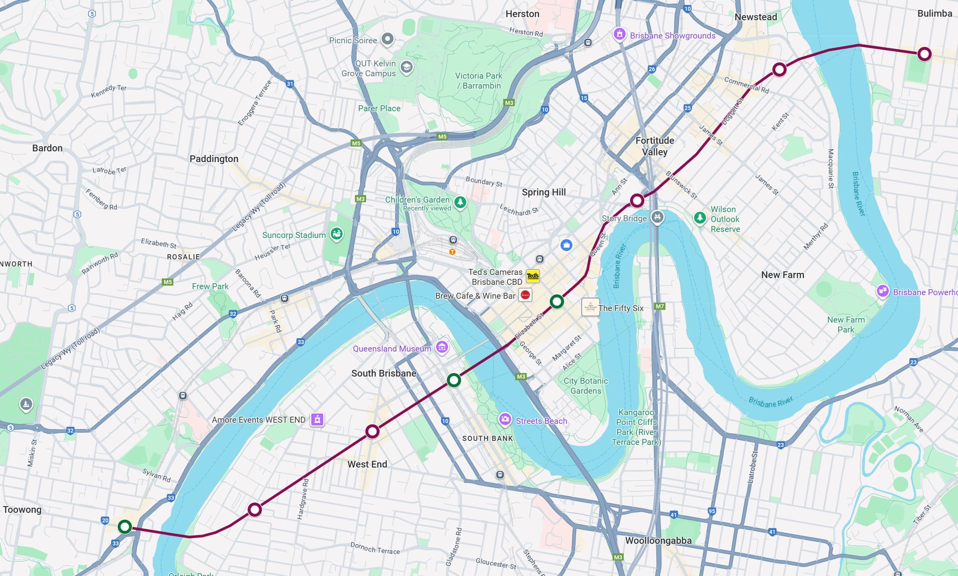
The likely crossing point (upriver from the Bulimba and Teneriffe ferry terminals) well clear of the cruise ship terminal, and there are very few (zero?) ships that would need more than 12m of clearance which ever go upriver that far. The Story Bridge is 30 above HAT, while all other bridges are 11-13m.
I’m mostly interested in your views about whether sacrificing marine navigation (over 12m clearance) on the river above Bulimba would be worth the substantial public transport benefits. For me it’s an easy “yes”.
TMR need to expand their investigation. The product is transport across a river.
There are a few options available for that. For example, a gondola system, improved ferry service, or a tunnel. These are options in addition to the bridge option.
The tunnel option could work, as it could allow both bikes and buses in it, and wouldn’t have the visual impact of a bridge.
And before anyone mentions flooding, you would just close it in such an event and pump it out after.
As a regular commuter from Teneriffe to Bulimba (I am a riverbend books regular) I often think about a Pedestrian Bridge or tunnel over there. The ferries are great, but being able to just walk would be better.
Not really though. The video shows that La Paz’s terrain is extremely rugged and alpine to the point where gondolas are really the only viable form of PT. Brisbane’s terrains is incredibly tame compared to La Paz, so there are many more viable options compared to gondolas.
Another city that uses gondolas as a river crossing is London, but it as a woefully low patronage compared to the average pedestrian bridge.
The bridge option has a few issues in this particular location though, and a gondola or aerial tram is also a mode that can be implemented for a river crossing.
Roosevelt Island Aerial Tramway (USA)
Carries 2 million passengers/year, so similar to a BUZ
Runs at about 30 km/hr
Carries 109 passengers per cabin
7.5 min frequency in peak, 15 min frequency off peak
Cabin looks like it’s flat so bikes can probably be accommodated.
You probably could run something like this every 5 min or so.
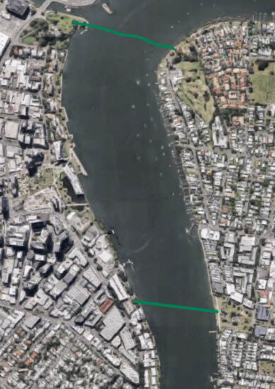
I could see a pedestrian bridge linking up Newstead park to Vin Lucas park or from the waterfront behind Goldsborough Place apartments to Bulimba riverside park. Both potential bridges link up some major parks and active transport links that see quite good use. So it would be highly viable to build an active transport bridge along either of the to two alignments that I drew in the map above.
Keep in mind that these bridges would need to be considerably high above the river level (think Story Bridge height). That would require a large structure with equally large approaches to make it work, requiring resumptions of large portions of the parklands you’ve promoted using, which may be opposed by the local residents/users of those parks. Newstead Park also has significant heritage values as well, that would need to be accounted for.
Why would a pedestrian bridge need to be as high as the story bridge? Other pedestrian bridges that I know of (kangaroo point, goodwill, kurilpa) are considerable lower than the story bridge, and they don’t require massive structures on either end of the bridge disrupt the areas the bridge link up to.
As OP pointed out, current maritime regulations mean everything downstream of the Story Bridge needs to be that same height. Upstream of the Story bridge is a different case.
So the discussion is more around: should we look at changing the maritime regulations to allow for easier bridge construction?
I think the regulations are pretty limiting and I don’t really see what for. I don’t see large boats coming that far down the river ever really. What is between the Story Bridge and Bulimba that a big ship would need to access anyway?
Also, if a high clearing is needed I would vote for some sort of moveable bridge, similar to what is present on the southern end of the new farm riverwalk, but at a larger scale
Kangaroo Point, Goodwill and Kurilpa Bridges (and Captain Cook Bridge) are all upstream from the Story Bridge, which is why they all have a height above highest astronomical tide (HAT) of less than the Story Bridge - Captain Cook Bridge is 12.7m, with the others roughly around that same level.
For comparison, the Story Bridge is 30m, the Powerlines at Bulimba are 41.4m, and the Gateway Bridges are 57.4m at the centre
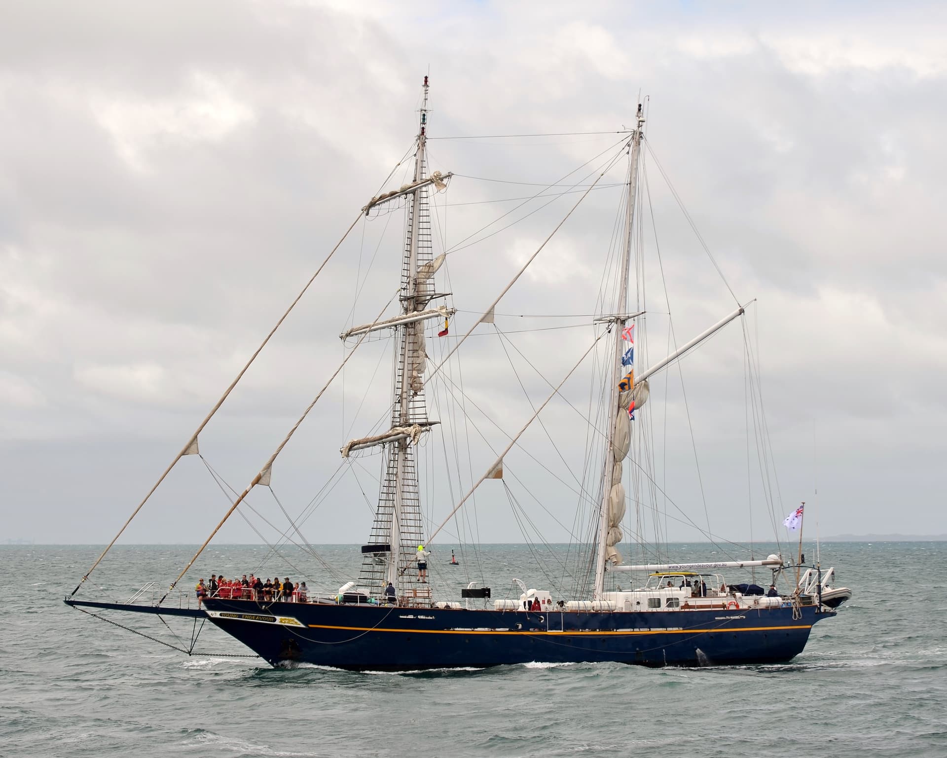
It’s not necessarily giant ships that the heights allow for, but tall ones. For example, the STS Young Endeavour visited Brisbane back in April, docking at Dockside Marina at Kangaroo Point. This replica tall ship, operated by the Royal Australian Navy, has a main mast height of 32m, meaning that it is limited to downstream of the Story Bridge (hence docking at Dockside).
The construction of the Kangaroo Point Bridge has actually caused issues with smaller sailing ships that formerly tied up at Gardens Point - due to the height of that bridge, a number of these ships are no longer able to use that mooring, because their masts exceed the height of the bridge.
Dockside is the big one, able to host boats up to 40m in length, with the Howard Smith Wharves able to take boats up to 25m I think? Also, while it doesn’t appear to be actively used at present, the pier at Waterfront Newstead still looks like it could be made operational again if they ever so desired to.
I’m no expert on boating, but for boats where much of the height comes from the mast could they just fold the mast down, hence making the ship shorter to fit under the bridge?
I think the best alternatives would be the currently existing ferry service for local trips and a tunnel under the Brisbane River (maybe as a subway of some kind? Or branching off the Cleveland line at Cannon Hill/Morningside?) connecting Bulimba to the city for regional trips