Concept: Western Busway Thread

Concept Only Disclaimer
The following concept is for forum discussion and exploration purposes only.
It is not expected to be funded or built as a priority anytime soon.

Western Busway Concept

There have been some concepts for rapid transit in Brisbane’s Western Suburbs. For example, a busway over the Brisbane river to connect the Centenary Suburbs to Indooroopilly.

Another related concept is rapid transit to UQ St Lucia, however mostly only a rail-based metro or mini-metro (e.g. Vancouver style skytrain) system has been discussed.

St Lucia Busway Extension as Rapid Transit

Simply extending the existing busway has not really been looked at. To explore this concept, the below map was drawn.

(Click image to enlarge)

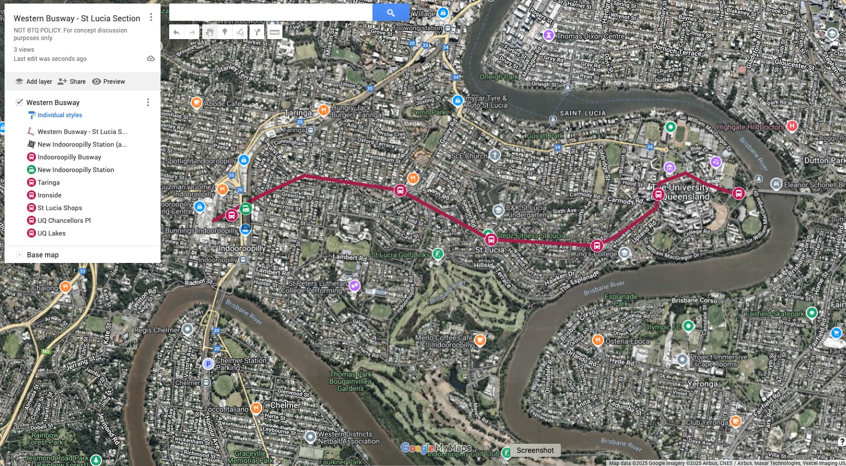
Length: ~ 5 km (Priority A, Tunnel)
Time: About 10-15 minutes from UQ Lakes to a new Indooroopilly train station (with straight platforms and bus interchange)
Stations: Four new stations (not including a new Chancellors Place busway station). These are St Lucia Shops, Ironside, Taringa and Indooroopilly.
Cost Estimate: 300 million/km x 5 km = ~ $1.5bn (estimate) (does not include new Indooroopilly train station + interchange).

Comments: Could use a mix of ordinary buses and Brisbane Metro BRT buses. Less strict engineering requirements than rail, no need for long testing periods, OHLE or electrical substations, new metro train depot. Scope for TOD around stations.

Buses can flow into existing roads and busway network without interchange (e.g. one continuous service from Carindale <> PA Hospital <> UQ <> Indooroopilly.) Medium peak capacity (3000 - 5000 pphd) based on services every 2-3 minutes.

Potential scope for future conversion to LRT, if future capacity increase is required. This would require longer platforms to be built for each busway station ($). Could connect to a future Western Busway Indooroopilly <> Centenary Suburbs.

Peak Hour Capacity Check

Q: Is there likely to be sufficient peak hour capacity?

  • Test values: Assume annual passenger volume of Ferny Grove Train Line (~ 6 million trips/year) and double this (12 million/year).
  • Back calculate test peak volume using the Pie Estimation Method

For 6 million trips/year: 6 million / 52 weeks / 5 days => 23,076 trips per day
One-way Peak is 10% of this: 23,076 x 0.1 => 2,307 pphd (about 15 Brisbane Metro BRT buses/hr or one every 4 minutes)

For 12 million trips/year: 12 million / 52 weeks / 5 days => 46,153 trips per day
One-way Peak is 10% of this: 46,153 x 0.1 => 4,615 pphd (about 30 Brisbane Metro BRT buses/hr or one every 2 minutes).

Conclusion: Test estimate falls within a reasonable range for Brisbane Metro BRT.

1 Like

Absolutely no way this would be $300m per kilometre. I would estimate $1bn per km at least

  • CRR is a slightly longer tunnel and was $6bn
  • a busway tunnel is physically larger and requires more associated infrastructure (ie. Ventilation)
  • The stations are the most expensive part. You’re talking about 3-4 new completely underground busway stations that will likely need to be in mined caverns, in an area of Brisbane with super expensive land. Not to mention the flooding issues with a tunnel entrance at UQ lakes

Revise your costs

3 Likes

^^Does the design above capture the schools such as Indooroopilly High and St Peters. These two schools create traffic issues each day.

There’s no real easy solution to this one except having no tunnel entrance at the UQ Lakes station site.

1 Like

I looked at the flood levels on a previous thread about a tunnel portal near UQ Lakes:

1 Like

I think the cost is way too prohibitive for a project like that. I think running buses along Sir Fred Schonell Drive and connecting at Toowong would be much cheaper and also a shorter distance. The main issues would be bus connections with rail at Toowong and also buses getting from one side of UQ to the other, but neither of those issues are insurmountable by any means.

Given how expensive proper busways (read, not transitways) are, and the demand UQ generates, I would prefer UQ Indooroopilly be a rail-based solution, preferably on the inner city metro. But with the low density, high land value, and topography, I also think it should have no intermediate stops between UQ and Indro.

I also wouldn’t want to see a busway built if it means we can’t get the rail solution.

I do like the Cross Campus Tunnel idea, building a decent interchange at Chancellor’s Place and facilitating cross town travel over the Eleanor Schonell Bridge. But I think it needs to be a shallow level tunnel generally under the roads / pathways, to avoid needing deep level tunnels and significant gradients down from UQ Lakes.

My idea is for an underground tunnel that links Sir Fred Schonell to UQ Lakes, see below.

Alternatively, if there was a real preference to head towards Hawken Drive, I would build it this way.

The downside to this is that it needs a few parcels on Hawken/Dell/Carmody, as well as losing the Chancellory and Admin Buildings to facilitate the curve into the station and the station itself.

2 Likes

Thanks for the feedback. Some responses below.

The $1bn/km value is what Sydney Metro costs per km. That includes substations, long platforms, OHLE and platform screen doors, which this won’t have.

I’m open to a side by side cost/benefit comparison if the Queensland Government thinks either mode might be viable.

Nobody will be residing in the tunnel, so it can just be closed during a flood event. Any water that gets in can be pumped out.

I think it would be cheaper too. But you’d get that bus route connection anyway once the UQ Green Tunnel / Cross Campus link was built. This would be after that stage was completed.

I’m not so sure flooding is the barrier it once was either, as there are now engineering solutions for this.

Here is an example from Kuala Lumpur, Malaysia. This road tunnel carries a motorway.

During the annual monsoon event, a flood event triggers the motorway to be closed and the tunnel acts as a flood diversion tunnel.

Once the flood is over, the tunnel is cleaned and water pumped out. Apparently this takes 48 hours to complete.

The tunnel has been closed and flooded multiple times, as intended.

Kuala Lumpur SMART Tunnel

Flood closure procedure

Four stations in five kilometres is excessive, and that’s before including Chancellors Place. It’s about 3.5km as the crow flies from Indro station to Chancellors Place. One intermediate station in that distance is sufficient, either Taringa or Ironside. This should also enable the tunnel to be a little shorter. The rest can be reached relatively easily using surface level buses as they’re pretty much all on the same continuous road except Indro.

Remember that any new buses going forward have to be zero emissions. By the time anyone would finish constructing a tunnel like this, I would imagine there would be enough ZEBs available in the TfB fleet to restrict the tunnel to ZEBs only, negating the need for extra ventilation.

Not sure I’d call St Lucia low density, there are plenty of apartment buildings and townhouses along Swann Rd. There’s a case for an intermediate stop somewhere along the way to help service that density, at least if it were busway.

I think it’s certainly possible to have a rail link along the lines of green team’s proposal for the Brisbane Subway alignment. There’s little point having a stub or trying to duplicate the Eleanor Schonell Bridge.

But this would be expensive as hell and subject to political wrangling. Any party that signed off on this would likely be accused of only being concerned with the inner city while short-changing the outer suburbs. At least the busway tunnel can be sold as enabling a future extension along the Western Freeway to get a busway to the Centenary area.

Perceptions like that do matter to politicians. The Victorian government is currently getting savaged for (among other things) embarking on a big expensive rail tunnel instead of upgrading the lines to the fastest-growing areas in the outer suburbs. Never forget that politics often gets in the way of what is possible.

Hilly Terrain

Well, it may seem so at first, however the area is very hilly which reduces the walk-up radius around stations. So there is a need for more stations just to get decent coverage as the terrain is not flat.

The stations are indicative, so the locations can of course be changed, added to or subtracted as needed. It is a concept. Having 5 km / 5 stations (including Chancellors Pl) = 1000 m apart on average. That’s similar to what one would expect for LRT. Some of our QR train stations are closer than this value.

Stopping Patterns & Capacity

Another observation is that buses do not have to stop at all stations, if desired. For example, BUZ routes 150 and 130 omit Buranda station and other stops on the SE busway. The same principle can be applied here as well. That said, the estimated time (10-15 min) from UQ Chancellors Place to a new Indooroopilly station is short, skipping stations would not result in a significant time saving benefit.

Unlike a railway where mixing all stop and express patterns reduces line capacity, this isn’t a problem with this busway.

Brisbane inner city rail-based metros are non-serious proposals

Agree. That green metro line in the image posted is about 14 km long. Based on 1 billion/km (Sydney Metro), that would come in at about $14b. Or about 3x the cost of an East-West busway or metro connection from Indooroopilly <> St Lucia <> UQ.

These sort of Paris-style metro proposals tend to be included in planning documents for their talking point value. The public looks favourably on these ideas. But they do not seem serious or viable proposals. No progress on this inner city metro concept appears to have been made since its inclusion in the Connecting SEQ2032 Plan (released 2011).

Some “green tunnels” or green bridges for buses under or over the Brisbane River at Bulimba-Newstead, West End - St Lucia, and Bellbowrie-Riverhills could potentially achieve similar connectivity of the green metro line much faster minus the price tag. Inner city LRT could also be another alternative.

A rail-based metro mode is better suited to very high volume tasks. Such as replacing the SEB (which carries the equivalent of a metro already - 40 million trips/year), perhaps a corridor parallel to it, or CBD-Chermside.

Sydney Metro and Melbourne SRL are not “Paris Style”

It is worth noting that Sydney Metro and Melbourne’s Suburban Rail Loop (SRL) are both primarily aimed at outer suburb line haul transport. They are not inner city “Paris Style” metro services like the the green metro line is.

Melbourne has so many rail lines and stations. A good starting point is doing whatever is necessary to allow 10 min trains on virtually all suburban lines.

It’s been easy to jump from those desires to the notion that since Australia doesn’t have metros now, it needs to build them. But Bowen’s work in Melbourne (and our own work on the Sydney Morning Herald inquiry) are pointing out that our cities already have a network of grade-separated rail lines covering the areas of European density, and that the quickest way to get a “metro” level of mobility is simply to run these lines much more frequently.