You don’t always need much road, but you almost always do need some road.
Yes, we can think about if there’s better ways for service vehicle access to any given building.
You don’t always need much road, but you almost always do need some road.
Yes, we can think about if there’s better ways for service vehicle access to any given building.
Look, wanting to minimise road traffic in the inner city is an admirable goal, but it has to be done in a realistic manner.
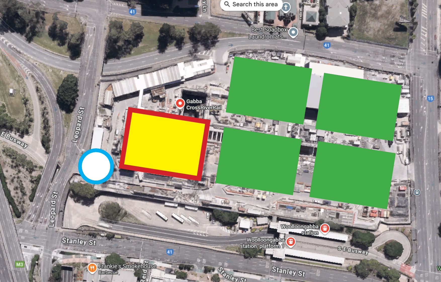
If you had residential developments that are located on the green squares, you can’t realistically service them from only the white circle. For example, no garbage collection firm is going to agree to manually wheel commercial dumpsters from those sites to the white circle for collection, nor can you expect residents or tenants in the towers to move them themselves to that location (the response to that from both residents/tenants and bin collectors would likely be quite colourful). Then you have a host of other issues ranging from supplying retail and/or F&B operators in the base of the towers to food delivery vendors bringing a hungover resident a kebab or vindaloo! And that’s without counting the issue of carparking - like it or not, such residential towers will include residents’ carparking, and that carparking requires access.
And then you have a different situation with the Brisbane Live Arena, which is to host concerts from major musicians - the stage set up and equipment for these types of concerts are usually transported in multiple semi trailer trucks over the days and weeks prior to the concert - Taylor Swift’s Eras tour reportedly required some 90 semi trailers, Metallica uses some 50 trucks, and metal band Iron Maiden travelled the world in Boeing 747 (known as “Ed Force One” after the band’s mascot Eddie) which were piloted by the lead singer. You can’t accommodate that amount of freight in that one spot - they need to be able to access the sub levels of the arena to load and unload, and that requires an access road from Leopard Street to the stadium.
I am not saying don’t have entries off the main road (which desperately need to be changed from the vehicle sewers/freeway ramps they are today).
I am saying there is 0% need for a cross-block road between the Train and current busway station.
Wait, the cross block road will be between the rail and busway stations?
A trainload (or arena load) of busway-bound passengers may be willing to wait at traffic lights to cross a major road like Main St, but they sure as hell wouldn’t bother to wait for lights to cross a small cross block street. Hopefully there is a sensible crossing solution planned.
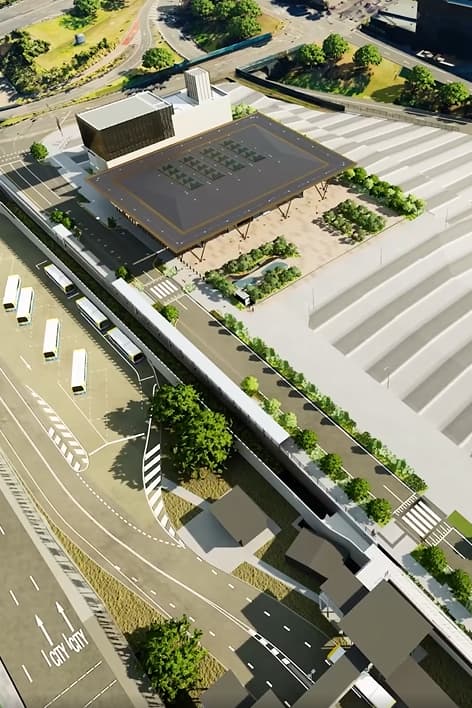
Here are a couple of screen captures from the video walkthrough showing the roadway, which looks to feature two raised crossings - one directly adjacent to the CRR Station plaza, and a second one connecting to the busway. There is also a partially covered walkway between the road and the busway cutting.
I imagine that this road will be closed or at least heavily controlled on game days.
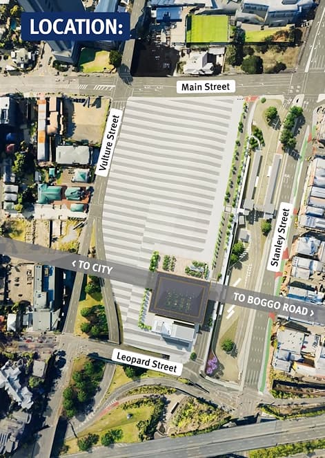
Utterly and completely does not need to go any further than back of the Station Tower.
I don’t disagree, however I don’t think it’s worth wasting our breath on the issue. There’s nothing across the road except for the busway station, so if it remains a raised zebra crossing, it will be perfectly safe. We can push for the speed limit on that street to be 20kph or alternatively push for one end (Main Street) to be non-connecting.
That might be a viable option, as Leopard Street does already have a north bound lane in place especially for traffic leaving this road (formerly the GoPrint carpark), so it doesn’t necessarily need to connect to Main Street for northbound connectivity. The road does still need to run through the majority of the site though.
I would expect a low speed limit to be in place for this road to discourage any rat running - not that it would be a particularly attractive rat run route - you would either be crossing or turning off Vulture Street to reach it.
Hopefully it will all change when Brisbane Arena is developed but it is extremely frustrating that Brisbane/SEQ cannot see beyond the bonnet of a car even in an area that should be 1000% car-free. Additions are hard to break.
You’re still going to have the road going through the majority of the site to service the Brisbane Arena.
Thinking about it, the heavy vehicles that will require access to the arena might actually reinforce the need for an exit onto Main Street. I don’t know how large-vehicle-friendly the northbound section of Leopard Street is.
I’ve been having a quick squizz at the corridor between Yeerongpilly and Dutton Park.
Are we actually satisfied that we can’t fit 4 tracks in (except maybe for some modest partial resumptions)?
I am assuming it gets too complicated trying to have 4 tracks through Dutton Park (ie not feasible to put a crossover in from the dual-gauge to the CRR up track between the north end of the Dutton Park platform and the flyover), so I am operating on the assumption every train stops at Dutton Park. South of Dutton Park, roughly in line with Cottenham Street, could you have a fourth track for expresses on the eastern side, cut around the southbound platforms at Fairfield and Yeronga (no fourth platforms), and build a fourth platform on the western side at Yeerongpilly? (The outer platforms at Yeerongpilly would probably not see regular use outside of shutdowns and the Brisbane International.)
South of Yeerongpilly it appears there would be ample room to have 4 tracks all the way to Kuraby, just a bit of playing around with the existing layout (eg at Moorooka, southbound Gold Coast trains would go through the current southbound platform without stopping, southbound Beenleigh trains would stop at the existing northbound platform, northbound Beenleigh trains would stop at the new third platform and northbound Gold Coast trains would pass on the other side of Clapham yard).
Salisbury will get interesting if you want a grade separated connection from the eastern-most track across the Beenleigh “local” tracks to get over to Acacia Ridge.
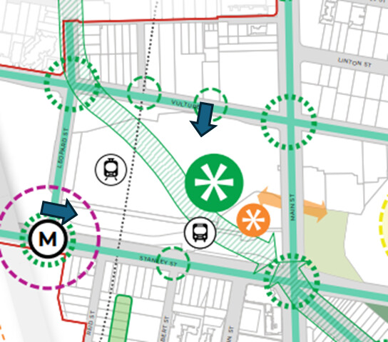
Are both of these intersections left in and left out only? Might explain why there’s one at each end.
Main Street is left in, left out only, while Leopard Street is left in, left & right out.
It’s not particularly in its current state.
I used to work at that site in it’s previous configuration and it’s worth noting there were access points from Leopard , Main and Vulture Sts. I can confirm, at that time at least, there was minimal rat running.
One might rat run from Stanley St or main St northbound if you wanted to access Leopard St/River Tce northbound I suppose, but there’s really not much gain compared to using Allen St. And I can’t think of a reason to use the Leopard St entry southbound as you would have to left-turn onto Main St, and you may as well have used Vulture St.
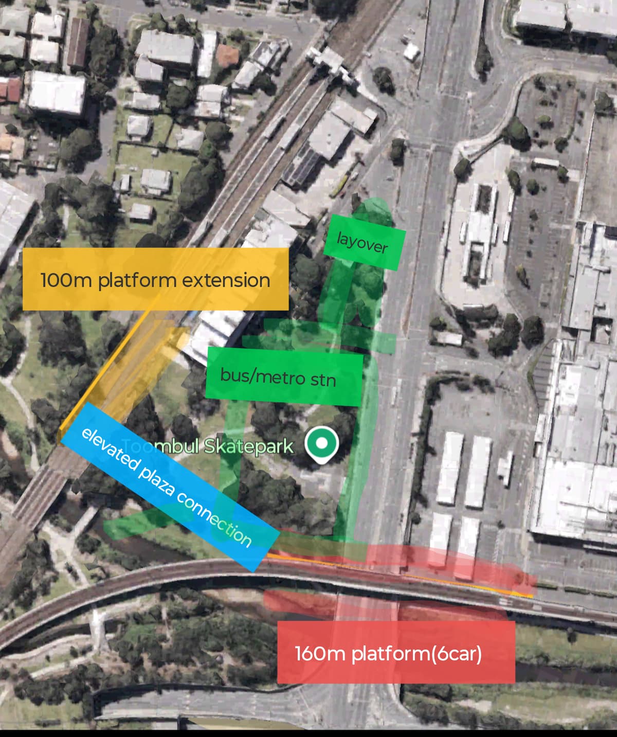
I went down to Toombul the other day and have reframed my initial thoughts slightly based on future 9 car CRR. I don’t think a complete rebuild is needed with the airport connecting to the fast pair. The existing flat junction is sufficient and maps better with the existing sectors. There is enough space to the south of the current Toombul station to extend the platform to the south. It would require the rail bridge over kedron brook to be upgraded, which also could enable the slight dogleg to be straightened out.
You then have an elevated station on the airport line on the two track section over sandgate Rd with the bus station occupying Ross park.
Again the main goal would be to alleviate Eagle Junction pressures, and maximize benefits of whatever future development happens in the old Toombul shops precinct. forgive my crass overlays, but I’m sure smarter people than I could create something that massively benefits this area and the wider efficiency of the network
Toombul these days hardly seems like the destination that needs two rail stations and two different bus stations.
There would be no support for removing greenspace parkland for a bus station.
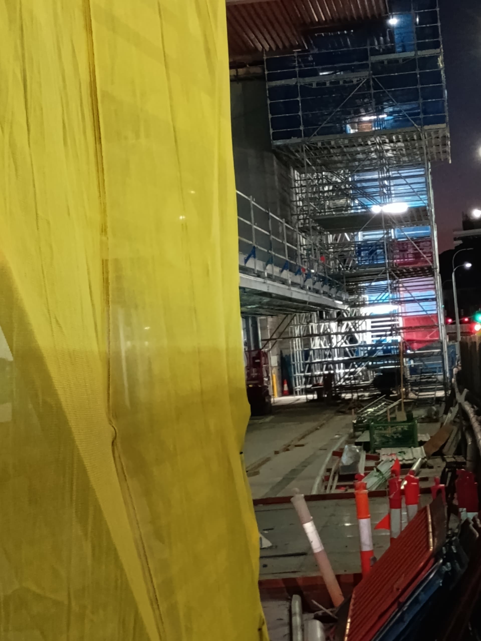
Platform 1 @ Roma Street progressing
They are also busy with the new vertical entry on platform 2. They could well open together.
Platforms 1 and 2 are progressing. I wonder if they are aiming for a end of January completion for these platforms. It will be great once open, as it will make transfers between other platforms and between 1 and 2 much easier.
Apparently XPT Sydney services or the new long distance trains will resume from Roma Street platform 2-3 in April 2026. So platform 1 and 2-3 could be fully open coinciding with this date or maybe a month or two before.
To repost what i’ve posted to SEQTA:
Pimpama Station opens Monday, October 20th.
I don’t believe the official Translink announcement has gone out quite yet, but it’s in the public GTFS data.