This thread is for identifying and discussing local road improvements that could significantly enhance access buses into areas currently underserved or disconnected. The focus is on small, strategic changes (e.g. turning lanes, signal priority, new links, bridges or safe turnaround points) that make it easier to extend or improve bus routes. These upgrades should ultimately support better frequency, reliability, and coverage of the bus network across Brisbane and SEQ.
Concept Extension of BUZ 385 into Ellendale and Ferny Grove
Ellendale is a rapidly growing suburb near Ferny Grove that has poor PT access.
A road connection between Ellenbrook and Mt Nebo Road would allow buses from the Gap to be extended through Ellenbrook and terminate at Ferny Grove Railway Station.
Local resident groups appear to back the road connection as well
Image: Dashed blue line where a bus extension from The Gap to Ferny Grove could be placed (approximate). Other lines are BCC bus routes in Frequent Network Mapping colour and thickness format. Red line = Western part of BCC BUZ 385.
Notes
Upper Kedron-Mt Nebo Road Connection Gains Momentum
The road connection between The Gap and Upper Kedron has taken a significant step forward after the Deputy Premier directed State departments to engage with BCC on modifying the Ferny Grove–Upper Kedron Neighbourhood Plan. The decision follows strong community advocacy, including a petition with approximately 1,400 signatures.
Connecting Upper Kedron to Mt Nebo Road
Ferny Grove Upper Kedron (FGUK) Residents Association (https://fguk.org/)
This proposal could open a can of worms… IIRC, it was The Gap residents protesting against the Ellendale development that saw any connection between Ellenbrook and Mt Nebo Road restricted to emergency vehicles only (and not even built AFAIK).
That’s one local residents group that does, and one - often much louder - group of residents that likely won’t. The Gap is up there with areas like West End for their NIMBYism, and considering this connection will push more traffic down Waterworks Road, I predict that a large outcry could follow any push for this.
Not saying that this isn’t a good idea, just one that could see a very large, very loud amount of opposition.
Yes, it’s possible. And by lending our support we can influence the outcome positively rather than prioritise what NIMBYs want over the needs of everyone else.
Just as with any bus reform they will be noise, but we have a mission to help people access better PT.
A BUZ extension here would be a big service improvement and also connect to Ferny Grove Railway station. Improved Bus-Rail connections featured strongly in our Policy Platform.
I think there could be a way to speed up buses entering and exiting Eight Mile Plains that doesn’t involve doubling back and exiting through the car park at Miles Platting Rd.
I noticed that for some reason School Rd doesn’t have access to the busway anymore thanks to the Rochedale depot eating the right of way, but I reckon that reinstating the connection would allow services like the 262, 280, et al to jump directly to Miles Platting or even the Gateway without having to sort various sets of lights.
If you add a middle reversible lane for buses at School Rd and a separate lane to access the Gateway, even better.
Wouldn’t the business case for extending a bus service to Ellenbrook ultimately come down to either it goes to a train station at FG with huge demand, or use a narrow mountainous road with no demand to The Gap.
I’d back the FG route as minimalist and logical. Isn’t there an existing bus route that can be extended there?
The busway doesn’t connect to School Road anymore because a large portion of School Road doesn’t exist anymore (much of this portion is now the busway). From Miles Platting Road, School Road only goes down as far as a roundabout with Priestdale Road, and from Underwood Road it only goes as far as the driveway of the block next to the Gateway Resort - no public roadway exists between these two points any longer, only a pedestrian footpath.
The only was to access this section of School Road that connects to Miles Platting Road is by travelling through the depot itself.
This is why I’m proposing the idea of rebuilding that small piece of road connecting School Rd to the busway. It could be relatively cheap in the grand scheme of things.
For the 262 and 280, they might be better off finishing Gardner Road all the way down to Underwood Road, and extending those routes down to Rochedale Station, turn off there and then run them all the way back up a completed Gardner Road to service those new estates.
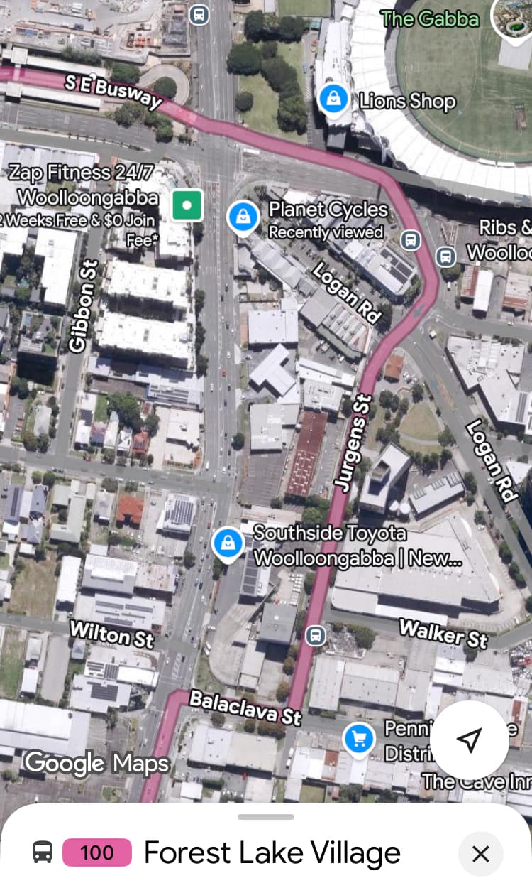
I would love to see a tweak to the Stanley St/Ipswich Rd intersection to allow the outbound 100 and 125 buses to turn right out of the Woollongabba Busway station directly onto Ipswich Rd rather the crawling round a few blocks and several sets of lights to travel via Balaclava St. A huge number of passengers get ~3 minutes added to their already slow trip every day for no good reason apart from terrible intersection layout.
Current proposals for improving PT in this area of Brisbane mainly centre around using the Trouts Road Corridor or the Gympie Road corridor for busways or heavy rail.
The general cost of these measures would be around $10 billion, and the timeline possibly 25 years or more to get all parties in alignment, funding agreed on, a design agreed on, etc.
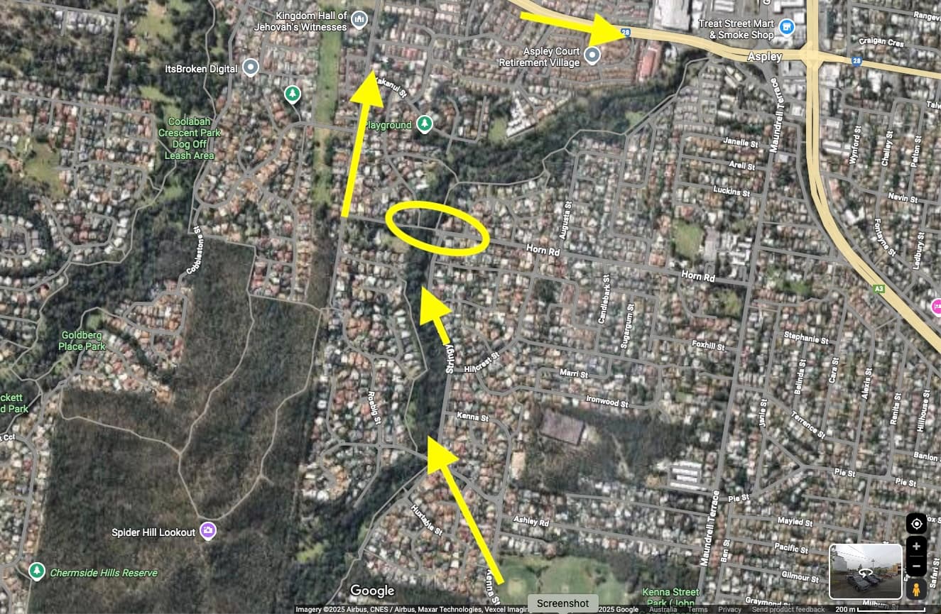
There may be a very low cost interim solution that can improve PT in this area very quickly: connect Horn Road in Aspley.
This would require about 100 m of road to make the connection and a short bridge over Little Cabbage Tree Creek.
The effect of this connection will be to enable a BUZ service to travel from Enoggera Rail Station, along Trouts Road (in parallel to the Trouts Road Corridor) and terminate at Aspley Shopping Centre (about 10 km bus route length).
This could potentially be in place within say 2 years.
Yellow circled area shows where the 100 m road connection would be required. Yellow arrows show the flow of an outbound bus route to Aspley Shopping Centre.
How does it work? I can see on street view there seems to be a bollard?
The Warrigal road Green link is a very similar short section of bus only road that significantly improves bus travel times, but doesn’t have any kind of measures to stop drivers using it. From my experience that seems fine, I think I’ve seen maybe a handful of cars use it ever