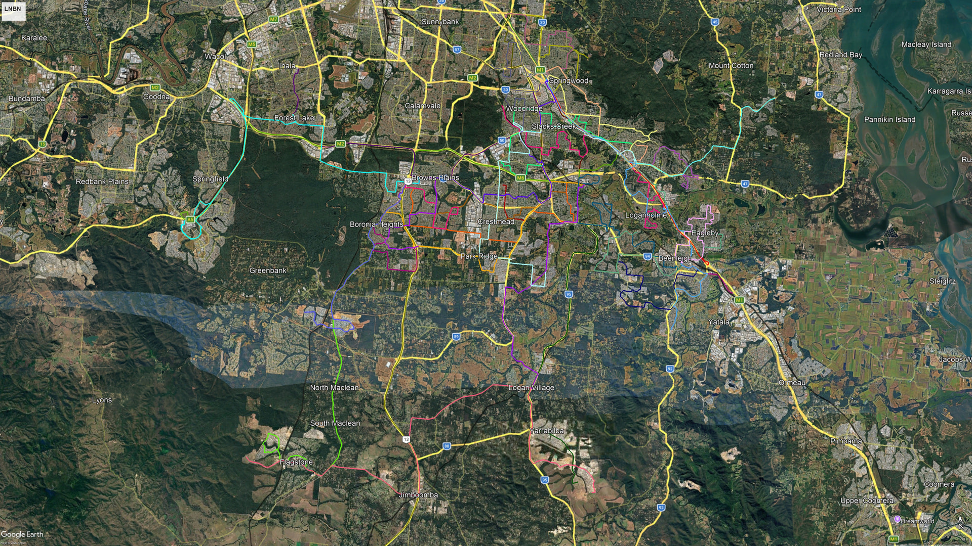
Changes:
- M1 (partially shown)
- Extended to Springwood per the Metro Plan
- All Brisbane City Council Routes that serve Logan (140, 150, 142, all associated Rockets)
- No changes except:
- 162 will be removed.
- 282 (Partially shown)
- Nil significant changes
- 534 (Partially shown)
- Removed Heathwood Detour (to be replaced by a future BCC Bus Route (thanks Emily Kim))
- 535
- Extended into a loop at Flagstone
- Removed detour stop in Greenbank
- 536
- New line from Greenbank to Browns Plains
- Serves most of developed Greenbank
- Follows 535 alignment to Browns Plains
- 540 (Partially Shown)
- No changes
- 541
- Minor route changes to improve coverage
- 542
- Minor route changes to improve coverage
- 543
- No changes
- 544
- New line from Park Ridge station to Loganlea Station
- Serves parts of Regents Park, Heritage Park, parts of Berrinba, Crestmead and Loganlea
- 545 (Partially Shown)
- Terminates at Loganlea via Station Road
- Detours via Millers Road, thence the previous 554 alignment to Eight Miles Plains
- No longer stops at Rochedale
- 547 (not shown)
- No changes
- 549
- New express line from Springwood to Inala via Browns Plains and Forest Lake
- Runs along Compton Road, Kingston Road, Wembley Road, Browns Plains Road, thence to Browns Plains Bus Station, thence Mount Lindsey Highway, M2, then exiting at Stapylton Road to follow the new 534 alignment to Forest Lake, then runs fully express to Inala via College Road and Partridge St.
- Serves parts of Underwood, Logan Central, Karawatha, Browns Plains, parts of Heathwood, Forest Lake and Inala.
- One of two new express links to mimic the cross link bus routes like the 550 and 560.
- 550
- No longer goes through Loganlea and follows the 545 alignment until Marsden.
- 551
- Original 551 removed
- New semi-express line from Loganholme to Logan Reserve via Logan Central, Woodridge and Crestmead.
- Uses Paradise Road to run direct, before serving Kingston, Marsden, Park Ridge and Logan Reserve as a feeder route.
- 552
- Detours via John Paul Drive, Brentwood Drive and Chatswood Road.
- Less coverage within Woodridge, and follows the 545 alignment. Lost coverage is given to the 554.
- 553
- Terminates within the suburb of Loganholme in a Loop.
- Serves local Tanah Merah and Loganholme, before continuing north via the current alignment.
- No changes until Trinder Park where it terminates at the new Trinder Park train station as per LGCFR.
- 554
- Detours through more of local Woodridge and Underwood.
- Extends as north as Underwood Road, before heading south along Stiller Drive towards Kuraby Station where it terminates.
- No longer serves Eight Miles Plains
- 555
- Terminates as north as Springwood.
- Stops at currently proposed busway station locations along the DH2LM corridor, including IKEA.
- After Loganholme, it extends southward express to Beenleigh direct via the M1.
- 559
- New express line from Loganholme to Springfield via Loganlea and Browns Plains.
- Travels via the proposed green corridor and busway between Griffith University Logan and the Mandew St fly-over to Loganlea, before traveling west on Station Drive to the M6.
- Travels via Mount Lindsay Highway to and from Browns Plains, before continuing on the M2 westward to the M5, before proceeding direct to Springfield Central train station.
- Not affiliated with the previous removed 559.
- 560
- Travels via the proposed green corridor and busway between Griffith University Logan and the Mandew St fly-over to Loganlea, before continuing on the former 550 alignment, through Waterford West and Marsden State High School, then along Chambers Flat Road, before continuing along the current 560 alignment to Browns Plains.
- 561 (partially shown)
- Remains the same until Marsden where it enters Waratah Drive, then Second Avenue to terminate on Bremer St.
- Will cover most of the former 551 alignment (these routes were predominantly duplicated).
- 562
- Starts at Loganlea Station on the Hospital side, before following a more local 560 alignment, then follows over the bridge over the rail line along Loganlea road, before continuing on the same 562 alignment.
- Beenleigh alignment has changed to be more local, before terminating at the new Beenleigh Station site for LGCFR.
- 563
- Follows the same alignment to Eagleby, before following a streamlined alignment, partially eastward to the new Beenleigh Station. Proceeds westward to Holmview Shopping precinct, south on Gardiner Road, through Waterford and Canterbury College, then to terminate at Edens Landing.
- 567 to reduce load in this area of Logan.
- 564
- Not affiliated with the original 564 loop
- New Anticlockwise loop line that serves previously served areas by the 563 in Eagleby
- Feeder Service for the Gold Coast Line
- 565
- Extended to Springwood to replace express 555 link in-between, and to reduce transfers.
- Diverts through local Tanah Merah to better increase coverage.
- Stops at the Eagleby Service station in both directions instead of one direction.
- Minor route changes through Mount Warren Park and Windaroo to improve average speed.
- 566 (note)
- Will not be brought back, however, select 565 inbound services will continue to the City as a 569 without requiring a transfer (replicating the 566). Vice versa for the evening direction.
- 567
- Overhauled, no longer a loop, serving from Holmview Shopping Center to Beenleigh via Holmview, Bahrs Scrub, and some parts of Windaroo and Mount Warren Park.
- 569 (Not shown)
- No changes
- May provide continual services to the 565 and 570
- 570
- Overhauled, no longer a loop, serving most of Shailer Park and Cornubia.
- Southern sections to be served by the 282.
- 571 (note)
- Will not be brought back, however, select 570 inbound services will continue to the City as a 569 without requiring a transfer (replicating the 566). Vice versa for the evening direction.
- 572 & 573 (partially shown)
- Spur added along Kimberley Drive.
- 574 & 575 (partially shown)
- Minor route changes within Shailer Park.
- 576 & 577 (partially shown)
- Continues via new road in Rochedale to the very north, then to Eight Miles Plains.
- Will no longer stop at Rochedale.
- 578 & 579 (partially shown)
- 579 to now follow the full extent of the 578 route
- 578 & 579 to proceed southward via Dennis Road instead of doubling up with the 574/575.
- 580
- No longer serves Meadowbrook.
- Serves IKEA in both directions.
- 581 (partially shown)
- No changes
- 587
- Previous 587 to be renumbered to the 590
- New 587 serves as a cross-town link and feeder line between Yarrabilba, Logan Reserve, Jimboomba and Flagstone.
- Future-proofing for the S2B passenger rail.
- 588
- Redesigned near Park Ridge to provide better coverage
- 589
- Redesigned near Logan Reserve to provide better coverage.
- Terminates adjacent to the Carls Jr.
- 590
- Formerly known as the 587
- Previous 590 near Garden City to be renumbered to a more appropriate number
- Is now extended further south in Yarrabilba.
- No longer stops in local Loganlea.
- 728 & 729 (partially shown)
- Stops at the new Beenleigh Station
Most bus routes will be run at 15-30 minute frequencies, with busier bus routes running at every 7.5-10 minutes.
The new bus network has been redesigned with an emphasis on efficiency, user experience and coverage. All 3 elements were balanced to provide a better experience for the users. The new bus network also takes in multiple proposals from the community.
The new bus network relies on multiple pieces of infrastructure, including LGCFR, Loganlea to Loganholme Green corridor including associated busway, and the Metro extension to Springwood. In lieu of more accurate satellite imagery, or fully constructed roads in new developments, approximations were used to determine new road layouts for new bus lines. No part of the lines are fully accurate to the road they are on and are there for illustrative purposes. Further clarification with the new lines are encouraged.
Any feedback or thoughts are appreciated!