I wonder if at one point a pedestrian bridge could be built between Eden’s Landing and Loganholme, crossing the Logan River.
It would allow for a bigger station catchment area giving residents on the other side of the river a one-seat ride to Brisbane (which they lost in July after the 566 got axed).
I suspect expresses will use the outer tracks all the way from Dutton Park to Beenleigh. From Dutton Park to Kuraby I expect all stations services in the peak direction will use the middle track (which is not only cleaner with fewer clashing moves, but means trains stopping at Fruitgrove and Runcorn have an accessible platform). The counter-peak would be merged in this stretch, then split up between Kuraby and Beenleigh where every pattern has its own track.
The question is going to be what happens between Dutton Park and Yeerongpilly in the counterpeak. Might end up with all services stopping all stations, with trains exiting/entering service at Yeerongpilly to enter/exit Clapham. Yeerongpilly to Kuraby could be quadded. I also think Yeerongpilly to between Dutton Park and Fairfield could be as well with probably only very limited resumption needed but the scope of capital works needed would be greater to keep it as far as possibly within the rail reserve. A more direct express (tunnelled) route would be nice but I don’t see that being feasible compared with using the current perway.
There are some comparable situations in other parts of SEQ but they seem a lot more marginal (eg Parkwood East across the Smith St Mwy to Molendinar, with the closest part being largely industrial).
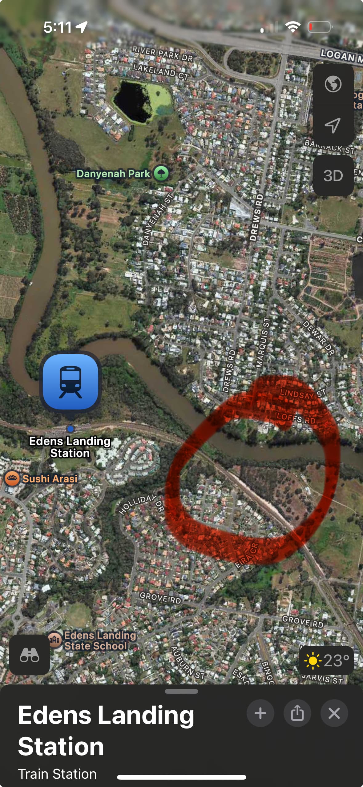
A bridge between Edens Landing and Loganholme would be good, but the most likely location for such a bridge would be between Drews Road or Marquis Street across to Houdini Terrace which, like most of Edens Landing, is a hike from the station. I’m hoping the active transport connection along the line will help to make Edens Landing Station a bit more accessible to the community, because it really is awful.
I think this would be a good spot to relocate the station with an adjoining pedestrian bridge. On top of that, close Holmview station and redirect the funds saved into other improvements to the project.
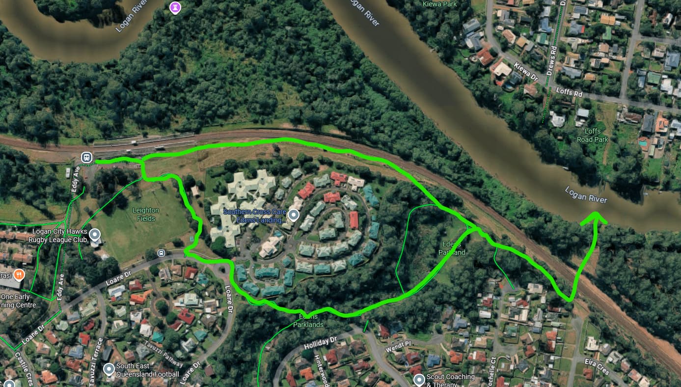
I think this routing for bike routes would be ideal, given both the topography and current infrastructure - a bikeway along the railway would allow for a shorter length to the bridge and minimizes conflict with drivers, and is relatively flat (rail corridor after all)
If this is built, I’d also hope for some more bike compound/locker parking within Edens Landing Station
The Logan and Gold Coast Faster Rail (LGC) project will double the tracks from two to four between Kuraby and Beenleigh, deliver modern and accessible stations, remove level crossings, improve park ‘n’ ride facilities, and provide improved walking and cycling connections to stations along the 20-kilometre section of upgraded tracks.
Engagement is now underway on the latest designs for four station precinct upgrades, including associated road changes, at:
Kuraby
Trinder Park
Woodridge
Kingston.
Designs have been developed by the LGC Rail Alliance, incorporating feedback from prior community and stakeholder consultation.
Was this along the rail line or the veloway extension alongside the highway (or is it the same thing?) - you will not see much cycling infrastructure with the LNP Government if it is even close to the highway (I wouldn’t actually discount them removing the Gateway bikeway for future widening).
This is not the V1 Veloway that is gradually being extended along the pacific motorway as they move south adding more lanes.
As part of the LGCFR project, the original intention was to include a cycleway from Kuraby to Beenleigh that would parallel the train tracks.
It looks like there will be some remnants of it, as the latest designs appear to show a cycleway between Trinder Park and Woodridge. Comments from TMR have also hinted that there will be a cycle/walking bridge over the Logan River near Bethania. However, there is no sight of it between any of the other stations from Kuraby to Kingston.
I suspect that they ditched it to save $$ as the project probably continued to balloon in costs, and the state government want to look like they have costs under control.
A massive shame, as that area is utterly devoid of safe connected cycling routes, and this would have helped enable locals to safely access the upgraded train stations without needing to drive and fill up the park n rides.
Cycling along a train line is also infinitely more pleasant than riding alongside a motorway (aside from serving a different catchment to the Veloway).
That’s a shame, but it tracks with decisions made under the current Government. My local train stations long delayed accessibility update cut bike cages, a pedestrian crossing and more pathway entrances from it, which is pretty on brand for the LNP and QR (no car parking removed even though it’s a very walkable station). I use the Gateway bikeway all the time and it’s pretty unpleasant noise and sun wise (most of the vegetation planted has died), but it’s the safest route I have for most rides.
Anyone disappointed by the cutting back of the Active Transport track should make their feelings known by leaving feedback during the Community Engagement.
It’s a backward step not including Active Transport along the rail corridor. Unfortunately active transport advocacy has been tarnished in the media because of rogue riders on illegal eMotorbikes.