It makes good sense if that is the idea, but there isn’t any indication in the map (or elsewhere) about signalising the intersection with Federation Drive. They only mention a signalised pedestrian crossing.
I’d also be surprised if TMR are willing to install a wombat crossing such a short distance from a signalised pedestrian crossing.
Why not just Light Rail style bus stops underneath the platforms and have a layover area done the road in flood prone area leaving the Park N Ride for flood free Housing
Probably due to that plan requiring additional property resumptions - that flood prone land is all privately owned and, last I checked, still actively used for things like hobby farms and, more commonly, livestock agistment.
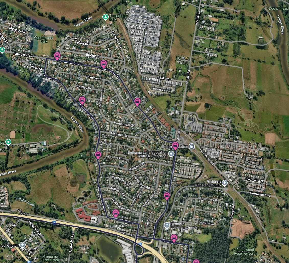
Also, not all buses terminate here - some like the 563 do, but others like the 562’s occasional journeys and the 564/568 loops wouldn’t require a layover space here. Hell, these services don’t actually service the Bethania Station stop currently - they only service the Station Road near Federation Drive Stop 100m down the road, and then turn straight into Federation Drive. It’s almost like a station in the BCC LGA!
I just don’t understand how putting on-road bus stops that do not align with the direction that local buses travel, and also point up a road that terminates just over 1.25km later, is of any kind of benefit? It just forces a route deviation for no substantial benefit.
Buses from Bethania, be they 563s starting from Bethania, or 562, 564/568s just passing through, do not travel any further north up Station Road than the station, they all use Federation Drive and Edinburgh Drive (with minor differences as to the exact route they take to rejoin Logan River Road). As mentioned previously, most of them don’t actually go into the station itself, but turn directly into/out of Federation Drive - whether this is due to lack of space at the station bus stop or lack of demand, I don’t know.
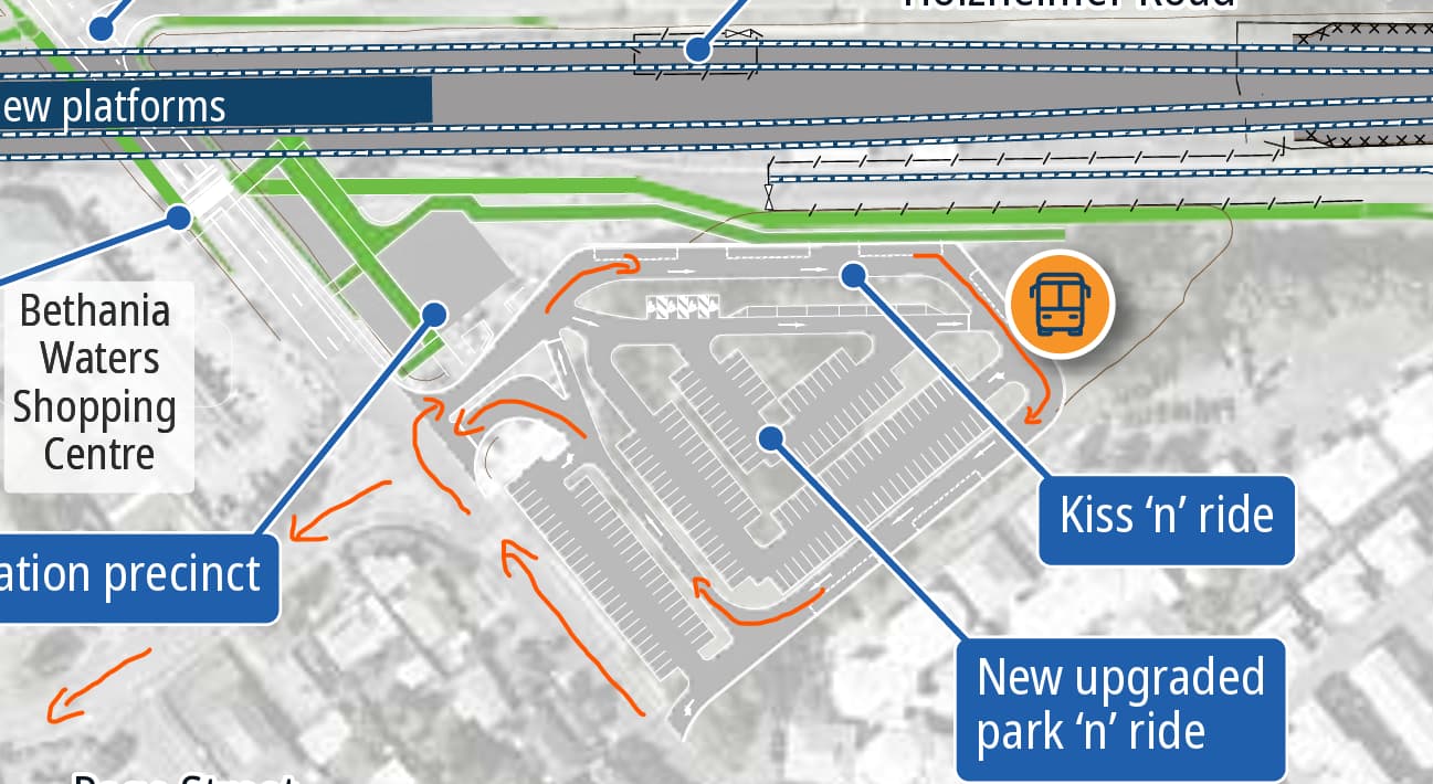
Notwithstanding the issue regarding the exact positioning of the stop within the park n ride that has been raised above, the overall layout of the park n ride should work pretty well because it directly aligns both the entry and an exit of the park an ride with the intersection of Federation Drive - buses can turn in, do the loop (three rights making a left) and come out directly onto Federation Drive.
Yeah, if worst case scenario the bus stop stays where it is, I still think the overall station design and the rail over road option is far superior to the original plans.
I agree. I wasn’t particularly aware of the local road network prior! Assuming the development potential for the area is nill (which the flood map suggests), a terminus style interchange is sufficient. I would still like to see it moved closer to the platforms though.
I’m wondering whether the park n ride plan may have simply been mis-labelled slightly.
The Kiss ‘n’ ride looks more likely to be the small bays below the spot indicated, and the three long rectangular spaces along the top section make the most sense sense as the location of the operational bus station than the single space to the right (it and the two spaces at the bottom would more likely be bus layover areas.
I think this decision is by design to keep the express runners on the outer tracks, allowing for seamless island platform transfers at Beenleigh and Loganlea, à la Hong Kong MTR.
That practice was brought to Australia by MTR as well for Sydney Metro at Chatswood, so there is precedent now.
PS - The Kuraby Overpass is an urban design horror show. That is the outcome of engineering completely focusing on road outcomes to the utter demise of a community.
My understanding is that the Gateway Motorway Overpass being 700m up the line meant that road over rail was the only viable option for Kuraby. There was not enough space between the overpass and the station to elevate the line.
This is a great decision and I support it but, at the same time, it introduces even more inconsistency to station and line design on the network. On the North Coast Line, express running is on the centre track and local is on the outers. On the Main Line, express running is on the up and down Mains on the northern side of the corridor and local is on the up and down Suburbans on the southern side. Now, there’ll be a third distinct pattern on the Gold Coast line: express running on the outers and local running on the inners.
I also thought that it was more common practice to have express running on the inners rather than the outers. Although I can’t find an obvious reason for this, I imagine it might be to do with lower cost thanks to less over/underpass infrastructure as well as potentially safer design for express services at speed.
While I understand the network is having growing pains, especially with the labour shortage and construction costs, consistent network design should be an important part of modernisation and expansion. As exemplified, it’s one of the major successes of Hong Kong’s MTR. The new standard station design across SEQ is great (although better characterisation for each station may help passengers identify their location), but standard design should extend to much more than just architecture. I don’t have any figures as to an average long-term financial saving of consistent design but I’m sure they would be huge, and, of course, you can see the benefits when it’s implemented properly. I’d love to see QR have a plan to integrate service provision with station design, which could look like a consistent arrangement of express and local tracks (outer local and inner express, in my preference), reduced platforms for local-only stations (as in LGCFR), grade-separated junctions at branches from trunk lines, etc. Being able to transfer between local and express services in the same manner at Loganlea as at Petrie, for example, would make the network so much easier to read, but it’s a design element that requires consistent planning and implementation.
Northgate to Petrie is a special case because of the triple tracks and layout at Petrie forcing an interesting peak expresss pattern. I’m guessing a big reason why the track layout for LGCFR was chosen was so that trains terminating at Beenleigh won’t have to cross the outer express tracks to begin their journey back towards the city, though they will have to cross the express tracks to access the Beenleigh stables. Probably in the future with a slight reconfiguration of the Darra flyover and proper quad track electrification between Corinda and Darra we’ll see this configuration again with Ipswich trains running on the outer tracks, and Springfield trains on in the inner tracks.
I have the suspicion the decision to put the stoppers on the middle tracks is also based on operational flexibility: that way Beenleigh locals could easily go south to Varsity Lakes (and vice versa) without much trouble, allowing for a potential two-tier service for the Gold Coast.
2tph Varsity Lakes - Sunshine Coast, express Beenleigh to Boggo
2tph Varsity Lakes - Exhibition (or Kippa-Ring), all stations
That way you get a consistent 15 minute service making for a much more compelling transport offer.
On the topic of track arrangements, what is the track arrange/will the track arrangement be north of Kuraby? i.e. how is the third track actually utilised? Do all trains use the outside lines in their respective up and down directions primarily, with the middle line serving as an overtaking line for the expresses to overtake all stoppers, or is it operated in a different manner?
I guess this probably changes again when the line changes to incorporate the Dual Gauge?