Ok everyone, you say that “a majority” of drivers are using the Expressway to bypass the city rather than access the city - who can provide the exact percentage?
Are we talking a vast majority of 75% - 25%? Or are we talking something closer to half and half (55% - 45% for example)? Back in 2006 the REX carried 150,000 cars daily, so that ratio would be pretty important.
Regardless, I still do not like the idea of funnelling traffic, even a reducing amount of traffic, onto George and Edward Streets. That retains those two roads as artifical traffic sewers. I would rather see overall traffic reductions evenly spread across the city’s road network, (perhaps converting one way streets back to two way).
But now we have Alice Street, Margaret Street, Elizabeth Street, Ann Street, and Turbot Street all being traffic sewers. I want to reduce that number from five to two.
I don’t see how removing the Riverside Expressway would achieve that goal.
If you remove the Riverside Expressway, what will happen is that they people will still use Elizabeth Street, Ann Street and Turbot Street much the same way as they otherwise would, they will just use George Street and Edward Street in place of the REX to get to them. Those two streets will go from being largely inner CBD circulatory roads, to ones that double as main arterial roads for the traffic to/from Fortitude Valley.
If you were to reduce those 5 arterials, my expectation is that Ann Street and Turbot Street would be the last arterials standing, as they form the core arterials through the Valley and up to Breakfast Creek Road and Kingsford Smith Drive. In my experience, they see much more traffic than Elizabeth and Alice Streets
I don’t consider Margaret Street to be as heavy traffic wise as the other roads, so that would probably be the first one you could get rid of. In fact, if you wanted to create bus lanes over the Captain Cook Bridge, I would run those lanes inbound over two lane Margaret Street ramp and outbound over the two lane Alice Street ramp, pulling the buses from the single lane and often backed up Elizabeth Street ramp.
The whole idea is that the total number of cars entering the city is much less. You wouldn’t use the city as arterial roads at all. If you were driving from the southeast to the Valley you would use the Story Bridge or a bus or train, for example.
Ann Street and Turbot Street could become useful and much nicer local streets, while Adelaide Street could become a bus-only transit mall, with wider footpaths.
The only cars entering the city would be ones for which that was their final destination. The idea of using the CBD as a through freeway like Turbot Street is 1970s car brain thinking and we should drop it.
There are bus lanes on William Street between QSBS and Elizabeth Street currently, but between Elizabeth Street and Margaret Street, William Street is now only a two lane road, so there’s not the available space to run dedicated bus lanes down there.
That is a great ambition, but removing roads is not the way to do this. Removing roads will not necessarily reduce car use, more likely it will simply concentrate it. You need a large investment made in further affordable public transport and/or wider disincentives introduced to driving in the inner CBD like a congestion tax, to reduce people driving to, from and through the CBD. And even then, many people are still going to drive. This isn’t car-brain thinking, this is just a simple fact due to how ingrained in Australian culture and society private car ownership is. In all honesty, it will likely be several generations at least before this culture of car ownership changes in any large scale fashion.
As I said above, Ann Street and Turbot Street will be the last arterials standing. You would have more luck pedestrianising the areas between Adelaide Street and Alice Street. I know this, because this is something that has been actively happening over the last 40+ years.
The creation of the Queen Street Mall and Reddacliffe Place.
The pedestrianisation of Albert Street between Turbot Street and Elizabeth Street initially - currently being expanded from Elizabeth Street to Mary Street.
Restricting Adelaide Street from George to Edward/Creek Streets to buses and local traffic only.
The removal and replacement of parking and traffic lanes along Elizabeth Street and Edward Street with separated bike lanes.
The above mentioned reduction of lanes on William Street between Elizabeth Street and Margaret Street from 4 to 2.
Pedestrianising Queen’s Wharf Road.
The removal of the all general traffic from the Victoria Bridge, and removal of most traffic from associated parts of Adelaide Street, North Quay and William Street to Elizabeth Street.
The plans to improve the pedestian amenity along Mary Street with expanded footpaths removed parking and rationalised loading zones (“Mary Street Vision”).
And as for travelling to the Valley, if I’m driving from the South East I really don’t want to use the Story Bridge. You have to deal with the roundabout, often congested Stanley Street, Allen Street, Vulture Street and Leopard Street and/or Main Street to do that. For a lot of cases, using the Clem 7 is the easier, more direct option, but they charge $6.50 per use for that courtesy.
They should be abolishing the tolls on the Clem 7 and putting a congestion tax on thru traffic going through the inner city - that’s the sort of thing that could reduce traffic on Ann & Turbot Streets.
That’s exactly what’s happened in cities that have tried it, as someone posted above. Freeways through city centres are removed and traffic get better. Seoul, Paris, San Francisco…
Did those cities get rid of those roads without any associated investment in their public transport systems, no use of congestion charges to discourage inner city driving, and no investment in traffic flow systems on surrounding road networks?
My understanding of the Cheonggyecheon project in Seoul, for example, is that it included a major public transport investment and optimisation project (new bus lanes and synchronising bus and subway services, which contributed to a 30% increase in bus usage) as well as the introduction of a car restriction policy and wider traffic flow investigations and methods.
Seoul and Paris both have world class metro systems and far higher density than Brisbane, with a far smaller car culture. It’s hardly a comparison to Brisbane.
While your ideas are admirable, have to agree that simply demolishing the REX isn’t going to be the silver bullet you think it is, as there simply aren’t enough decent alternatives for many people
I find it quite amazing that on a transport advocacy forum, there is constant pushback against any proposal which actually reduces support for private vehicle traffic even in the densest, most well served by public transport parts of the city.
Seoul does have world class public transport. But lets not pretend its not still a car centric paradise with the whole surface netwprk dedicated to the car.
Its city centre is more decicated to cars than brisbane or sydney.
The moral of this is underground metros can pretty much outweigh decades of US minded transport planning.
It sounds like you are changing your driving behavior based on congestion and difficulty navigating one route over another.. just as OzGamer is saying people will!
Congestion itself is a giant disincentive to taking a particular route, and sometimes (where no viable alternatives exist) to driving at all.
We’ve had 50 years of investment in making the peak hour commute to the city quicker. Not perfect, not quick enough, but this is the thing our PT system does best!
Coomera Connector forced into federal environment review
The final stages of the second M1 to link the Gold Coast to Brisbane have been halted, waiting for a federal government assessment due to possible environmental risks.
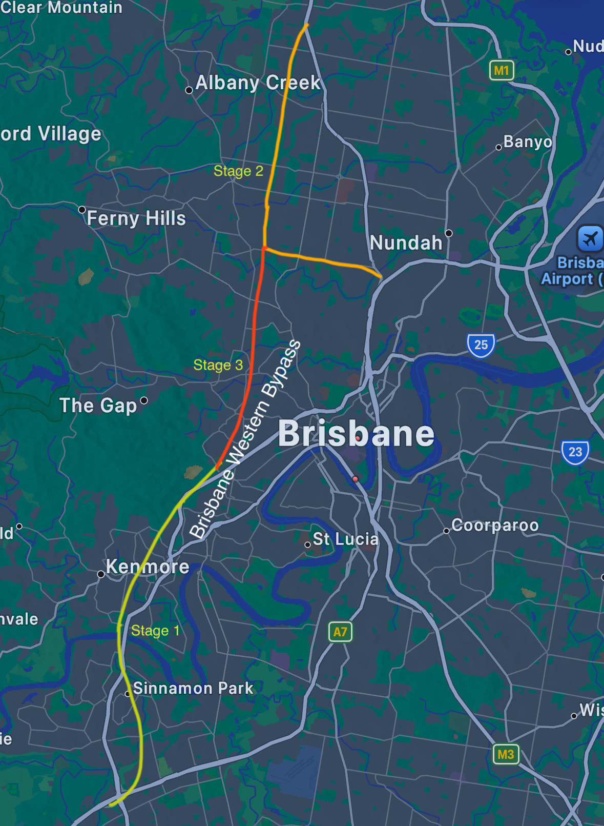
Specifically dump the Gympie road tunnel and instead joint the NWTC corridor with the dumped Centenary Highway Bypass Tunnel and include a Stafford road bypass tunnel to also connect this new tunnel to the Airport link. It would be done in 3 stages. First stage will ease congestion off the Centenary Highway. Stage 2 would effectively ease congestion off Gympie & Stafford Roads, and Stage 3 would link the previous two stages together thus completing the bypass.
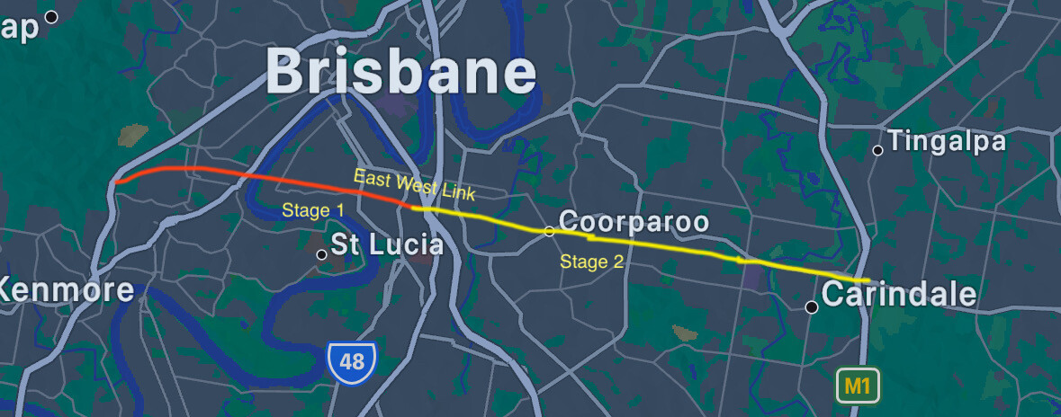
Additionally I would also build the East West Link. This one is an expansion on a previously planned Road tunnel. Stage 1 would be built first allowing traffic from the Pacific Motorway to connect to the Western Bypass Tunnel. This will be followed by stage 2 which would ease congestion off Old Cleveland Road. Eventually in turn this could connect to a new Redlands Motorway corridor that could serve the Redlands region before then heading south to meet the Coomera Connector North future stages.
In my opinion we’ve had so much investment in roads and freeways that it’s time for public transport to get some massive levels of investment. This project would be astronomical in cost too.