Starting a thread for noteworthy changes or issues with data including the GTFS feeds.
Not sure how long this has been the case but tonight’s my first time seeing rail replacement on GTFS Realtime. Big win for minimising disruption.
Starting a thread for noteworthy changes or issues with data including the GTFS feeds.
Not sure how long this has been the case but tonight’s my first time seeing rail replacement on GTFS Realtime. Big win for minimising disruption.
I guess this is a good thread to talk about Fluvial ![]()
(I’ve been kinda shadowy on it for a while to avoid pseud/realname crossover but that’s no longer an issue.)
For the folks who haven’t seen it, it is a visualiser for origin-destination patronage data along a route, like this:
Usually, GTFS data is used to establish a stop order. This is simple until it isn’t — we have all sorts of route variations, tails and part-time expresses, some of our routes do loops, some of them do figure eights…
SEQ’s patronage data comes aggregated by the month, but it is possible to filter it a little by time of day (weekday AM peak, weekday middle, weekday PM peak, weeknights, weekends). It’s also broken down by route and origin/destination.
However, QR is all bundled up as a single “Rail” route because the readers are on the platform rather than on the vehicle. I’ve been trying to work through the best way to deal with that (from configuration and auto-discovery) for… three years now.
How hard would it be to use this data to model a redesigned BRT style network. Yes of course changing routes will change behaviour but it would be an interesting analysis.
I wouldn’t rely on it too heavily for major network changes.
You don’t measure cross-river bridge demand by the number of people swimming!
If a route is well patronised despite being low frequency and it’s where you’d put a BRT route anyway, then sure, that’s evidence for an upgrade.
You can also use this data to think about patronage along a corridor.
E.G. for the SE Busway some people catch the 130 to Queen St but some people catch a P-rocket to the city; if the P-rocket didn’t exist, all that demand would have to go on the 130.
Yer it was that consolidation # that I was interested in. To see the patronage levels through just consolidating/de-duplicating.
Once the 124/125 changes happen that’ll be good data I reckon
TransLink data and tagging has never been great and I often see TSV/CNS routes mixed with SEQ ones (#weNeedUniqueQLDNumbering) but this typo is a new one this morning:
The 8:43am route 200 to Toombul Interchange is cancelled due to staff availability.
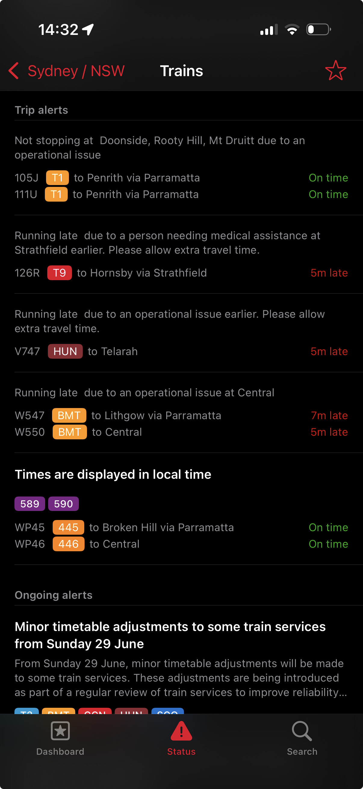
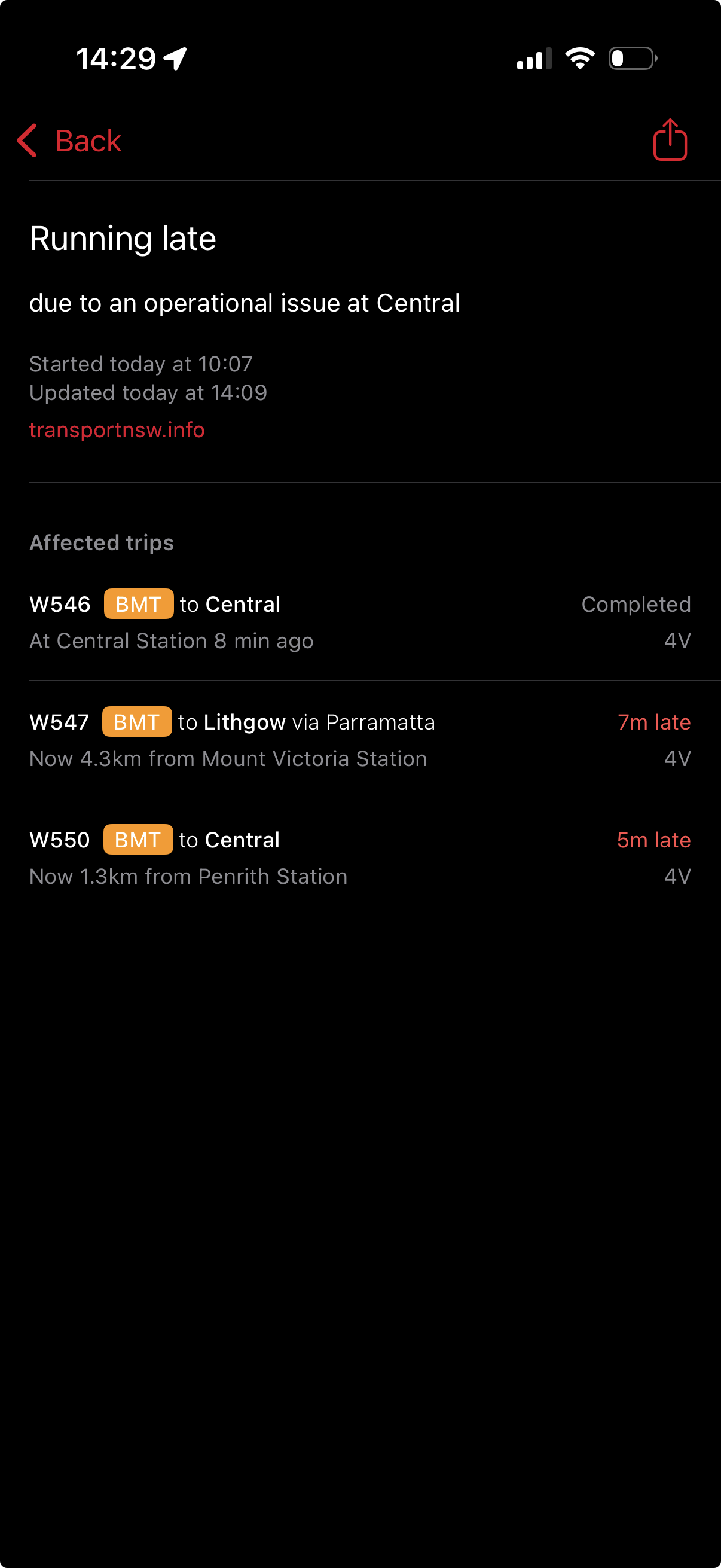
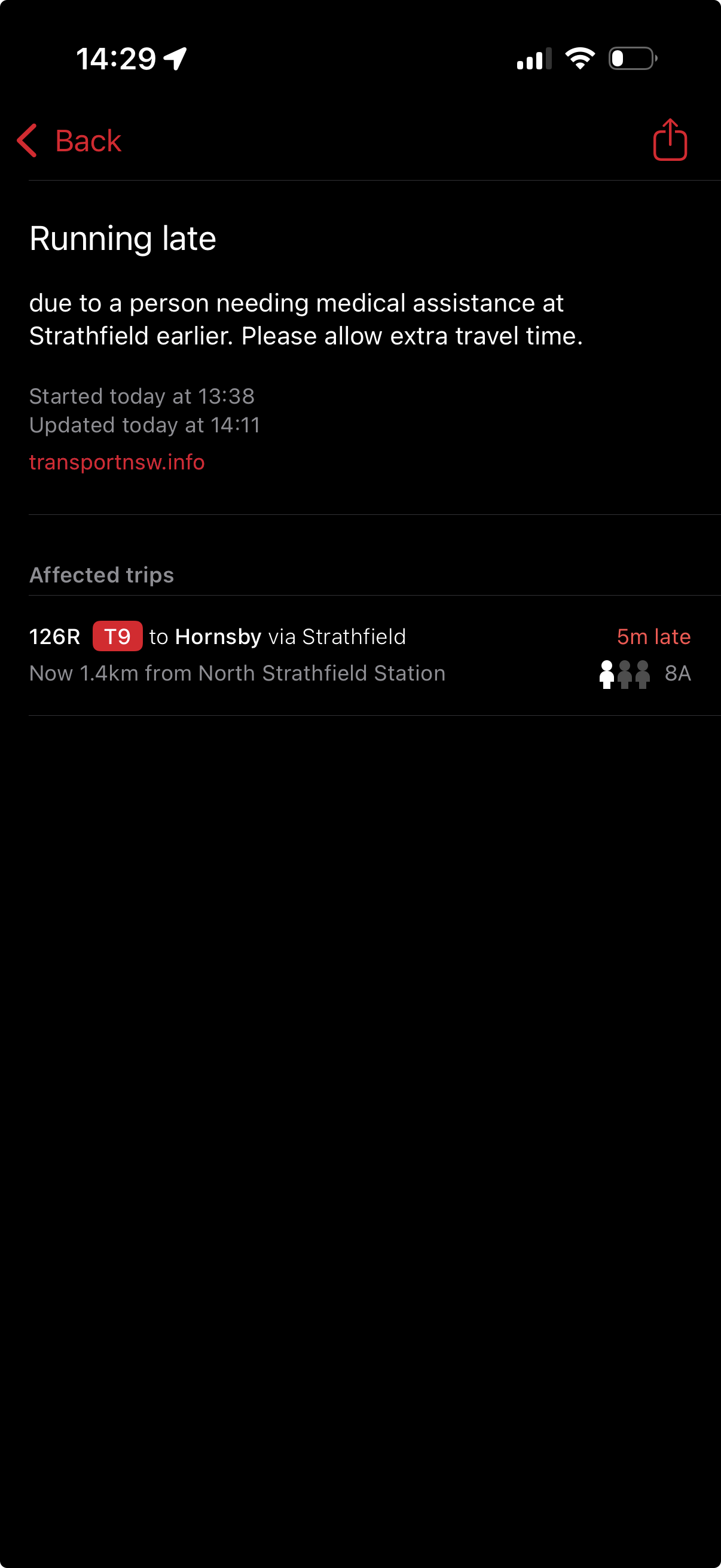
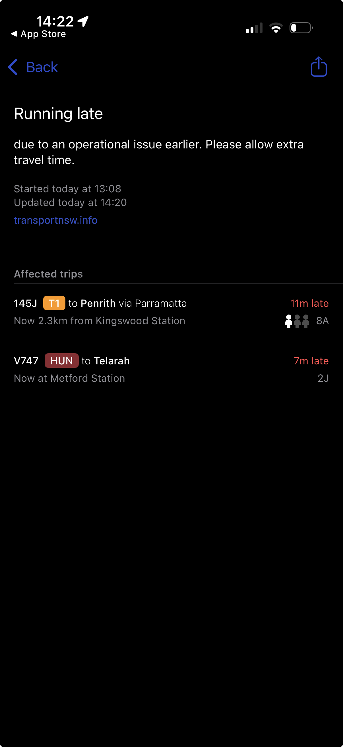
One thing I would absolutely demand from translink is (and I’ve mentioned this before) a better use of the GTFS feed to add more precise information, as done correctly by Transport for NSW over the border.
If a service is cancelled over there it gets correctly displayed as such on all systems, instead of being shown as just “scheduled” without any clarification.
When an alert is sent for a specific service, it gets tagged to the affected trip in question allowing for a more accurate and granular delivery of information.
Vehicles over there also send speed information which is very cool.
No more zones in SEQ data.
As mentioned in the previous update, we will be implementing a change to streamline the public transport zones across Queensland so that all stops will be designated as Zone 1.
The updated zones will be incorporated into the next set of General Transit Feed Specification (GTFS) files which are expected to be uploaded within the next day or two.
From TransLink developer Google group.
This leaves them open to introduce distance based travel in the future. The zonal system didn’t really work that well as there were too many inconsistencies.
Agreed. Should variables fares return, distance based (as the crow flies) is most appropriate IMO.
Trains are all over the place due to an incident requiring emergency services, and the real time data is down to boot. Not fun. It makes me think that Translink should be required to publish the uptime statistics for the realtime feed. It seems to be having issues on the regular.
I would say in general it’s been far more reliable than it use to be. There was downtime Friday (approx 30mins), and Saturday just gone (approx 3-4 hours), but prior to that it’s probably been solid for months - with the exception of Logan Coaches route 587.
I only generally track bus/ferry feeds, so I can’t comment on the QR uptime - but comparatively it’s similar to other regions but not as good as Sydney or SA. For interest, the Victorian Metro Bus feed is down EVERY day from approx midnight to 11am - with a fix not planned until early December.
I’ve been digging a bit into GTFS lately, with ambitions of making a transit website. It’s been fun, but one of the things that has most annoyed me most is that we seem to have an issue with naming things in Queensland.
An obvious one is bus stops; I think people shouldn’t need to remember such verbose stop names to be able to search it up online. Like “Accession Street Stop 21 near Coronation St” for example, I’ve standardised this to be “Coronation St/Accession St #21”, which is much easier. Note this is also named for the point of note first, rather than the street it’s on for convenience.
Another thing is train stations. They’re all officially named {station name} station in the GTFS (Varsity Lakes station for example rather than just Varsity Lakes). Per the GTFS guidelines, this is not allowed and to me seems unnecessary. If anyone on a transit website sees “Varsity Lakes”, they should and will assume this to be the station.
Train lines are just named for their destination at the moment, but this is potentially confusing for new users of the network as one colour has multiple names. A simple change here could be simply naming lines for colours, but I’d definitely like to see Translink / QR have a go at this when CRR opens. The current system for routes, with names like RPSP, doesn’t really make sense for users to see.
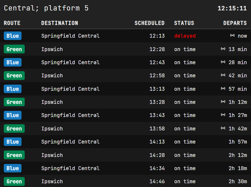
For what it’s worth, here’s my current passenger info display mock-up using colours as line names. Definitely needs some getting used to but I could see it growing on me.
Welcome to the community! I agree with you entirely. Translink is very bad at effectively using the GTFS schema in my experience. They don’t even mark routes as cancelled in the real-time feed most of the time. You have to check their X account and hope that they actually post a notice (often times very late might I add).
Translink has acknowledged the confusion with the current route names for Queensland Rail. Rest assured, they are working on something.
I would go one better and get rid of stop numbers anywhere outside the CBD area. They don’t seem to do too much except within the CBD area where you need to know where particular routes pick up and set down. I’d actually convert the CBD numbers into alphanumerics the way they do in Adelaide and give them a more useful name, ie clusters of stops on different streets but in the same locality would share the same prefix - for argument’s sake, “R” for Roma Street, “C” for City Hall, “Z” for Anzac Square, “E” for Elizabeth St, “W” for Wickham St, etc.
Ive also never really understood the logic behind the stop numbers. That said, with our population getting more diverse and where english as a second language becoming increasingly common, I’m all for using numbers in addition to names to make things more accessible, assuming they make sense.