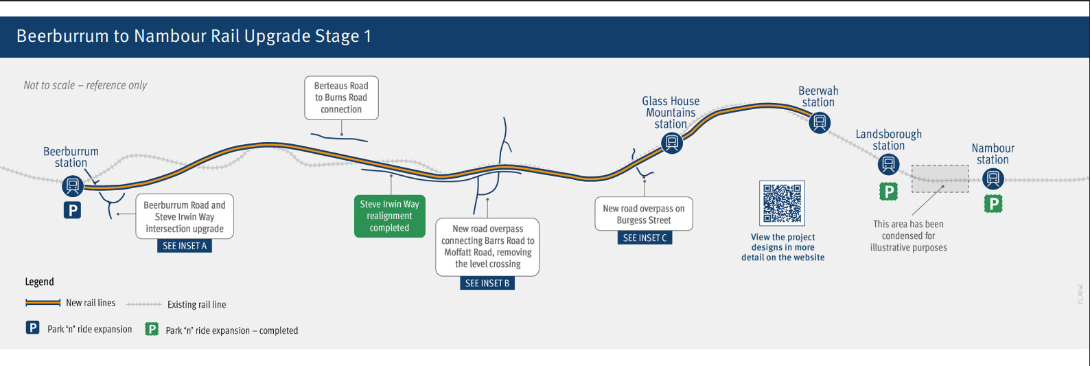
The Beerburrum to Nambour Rail Upgrade will increase the capacity and reliability of the North Coast Line, enabling more efficient travel and improved passenger and freight connections between the Sunshine Coast, Moreton Bay, Brisbane and beyond.
Stage 1 will:
deliver 3 new bridges
address 3 level crossings
expand 3 park ‘n’ ride facilities
duplicate the section of rail track between Beerburrum and Beerwah
construct a new bus interchange on the eastern side of Landsborough Station.
Key features
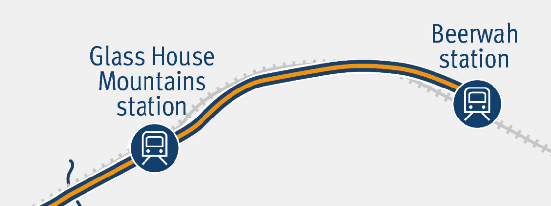
Duplication of the North Coast Line between Beerburrum and Glass House Mountains on an improved alignment.
Duplication of the North Coast Line between Glass House Mountains and Beerwah following the existing alignment.
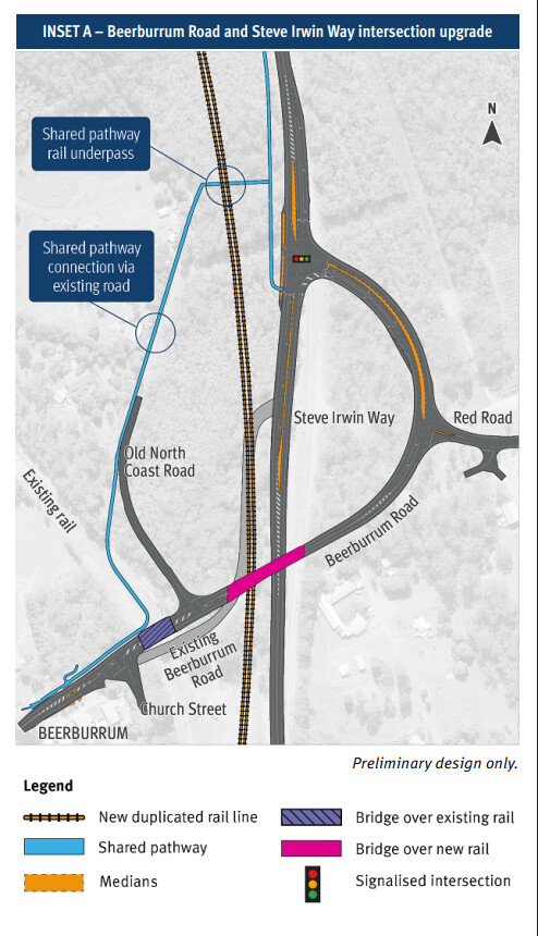
Beerburrum Road and Steve Irwin Way intersection upgrade including a new road overpass on Beerburrum Road.
Expansion of the park ‘n’ ride facility on the northern side of Beerburrum Station.
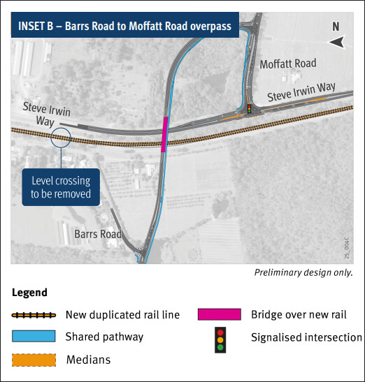
Replacement of the Barrs Road level crossing in Glass House Mountains with a new road overpass connecting Barrs Road to Moffatt Road.
Closure of 2 private level crossings with alternative access provided.
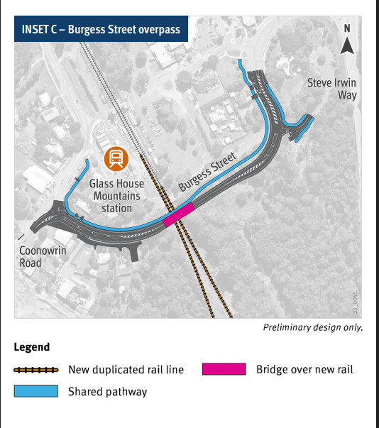
Replacement of the Burgess Street road-over-rail bridge with a new road overpass.
Hi all, have created this thread to discuss B2N, with main site establishing works set to take place over the next 8-10 weeks in preparation for construction of the Beerburrum Road and Barrs Road overpasses to commence shortly after.
Vegetation removal adjacent to Beerburrum Station was scheduled to occur today (19 Feb 25) for better site access and to allow staff to begin relocating underground services within the project footprint.
It’s not really too bad. The curve radius isn’t too small so it has higher speeds through the section. They have removed the worst section just after Beerburrum at least.
Mooloolah thru Woombye is the worst part of the alignment north.
While I agree with you entirely, getting the Beerwah to Beerburrum section up to 160km/h standard is basically impossible. It would require resuming hundreds of homes and a lot of farmland, plus massive bridges and a lot of earthworks in environmentally sensitive areas (Glasshouse Mountains National Park).
Are you sure you’re looking at the right project? DSCL is being designed for 160km/h from the ground up as it’s a preserved corridor, Beerburrum to Nambour is only a duplication and minor realignment of a small section of track to allow for slightly improved track speed. I can’t see anything about 160km/h on the B2N project page?
The actual section being realigned is only 6.5km long
After a lull it’s pleasing to see that work seems to be well and truly starting to pick up.
The site office seems to have dramatically grown in size last week, and vegetation removal on the Eastern side of Beerburrum Station has occurred over the last few weeks to allow access for underground services (I believe mostly fibre optic) to start being relocated to the new corridor.
This weekend QR will be testing and commissioning preliminary signalling system changes for B2N between Glasshouse and Beerwah, while at the same time aerial surveying and excavation to uncover buried services will also be occurring throughout the entire project footprint.
Still seems on track for major construction to commence in Q3-Q4, the sooner the better I say.
State clears the way for farmland on Brisbane fringe to be developed https://t.co/0GYAaaFGRQ Elimbah - Bleijie has now reclassified the land as category 2, which allows development applications to be lodged and considered for an initial 67 hectares of farmland.
This is already happening on a pretty big scale in Beerwah at least, there’s townhouses going up everywhere and even some proper unit buildings with 20, 40 and even 50+ units. Much of it is social housing currently but there’s also plenty of private investment as well. That’s why I’ve been trying to lobby translink to extend the 605 and 615 buses from Landsborough to Beerwah as a temporary measure to connect us to the coast until DSCL is built. No luck on that front yet though.
I am a huge fan of transit oriented development and I really think the government are shooting themselves in the foot by releasing land nowhere near PT in Elimbah for development but at the same time stonewalling the development of Beerwah East which will have the DSCL alignment running right through it. It’s a greenfields area with a future rail line running straight through it, now is the chance for them to properly develop medium density housing before the line and stations are built.
The state government has today released detailed designs for the level crossing removal and overpass constructions at Beerburrum Rd, Barrs Road and Burgess Street, with limited consultation open now for the proposed features of the overpasses, noting that no more changes can be made to alignment or overpass locations.
What’s interesting is that despite the project scope not including any realignments to the actual rail corridor between Glasshouse and Beerwah for cost and other reasons, it appears that the new duplicated track will follow an improved alignment within the existing corridor. I’m a little skeptical about how much they can fix, however even if they can reduce curve radius in the worst bend near GHM station to add 10-20km/h to the speed that’s already a big improvement.
Basednon inset A, it looks like they could replace the existing rail alignment with a shared path under Beerburrum road based on the fact they are building a bridge over the existing rail (notice the sharp 90° turn on the shared path).
Good catch, some kind of path or rail trail to acknowledge the history of the original NCL alignment would be very nice, a forward thinking project would even construct a path along the entire Beerburrum to Beerwah duplication at the same time ready to link to the additional active transport infrastructure being laid down next to the DSCL tracks.
Looking at the plans I do wonder how they are going to deliver this without major disruption to NCL passenger and freight movement - obviously the Beerburrum to Glasshouse section will be entirely new track through new alignment, but Glasshouse to Beerwah will share the existing corridor. I imagine unless they’re laying 2 new tracks and new OHLE and decomissioning the existing setup upon completion we’ll see some pretty big track closures?
I am also curious as to the timing of the planned knock down rebuild of Beerwah station. The project falls within DSCL, but the smart thing to do would be to complete this at the same time as the duplication so disruption is minimised. I think the two projects will overlap (Duplication completed 2027, DSCL starting in 2027 too, I hope) but I haven’t seen any mention of coordination between the two projects despite the fact that they are literally connected.
JFC. took them SEVEN years to finally release preliminary design for the bridges?
Beerwatcher, how long since the upgrades to Steven Irwin Way have been completed now? 2 years?