[!info] NOTICE: This is a concept thread for concept discussion purposes only. It is not BTQ Policy.
A thread for bus route proposals.
[!info] NOTICE: This is a concept thread for concept discussion purposes only. It is not BTQ Policy.
A thread for bus route proposals.
Route 29 Extension (2 options)
Forum member @cartoonbirdhaus has generously agreed to map concept routes for a Route 29 extension. Thank you. There are two options - Option A, and Option B (preferred).
Route Concept
Route 29 Extension:
RBWH <> Exhibition <> Fortitude Valley <> Kangaroo Point <> Woolloongabba CRR Station <> Buranda Busway Platforms <> PA Hospital <> Dutton Park <> UQ Lakes
Distance: About 11 km
Type:
This route is designed to support for all-day, high-frequency service with patronage on an orbital route (both directions).
It connects:
Proposed Frequency:
Every 10 minutes or better, all day (7 am - 9pm), 7 days.
Option A: Via Story Bridge (not stopping in Kangaroo Pt local streets)
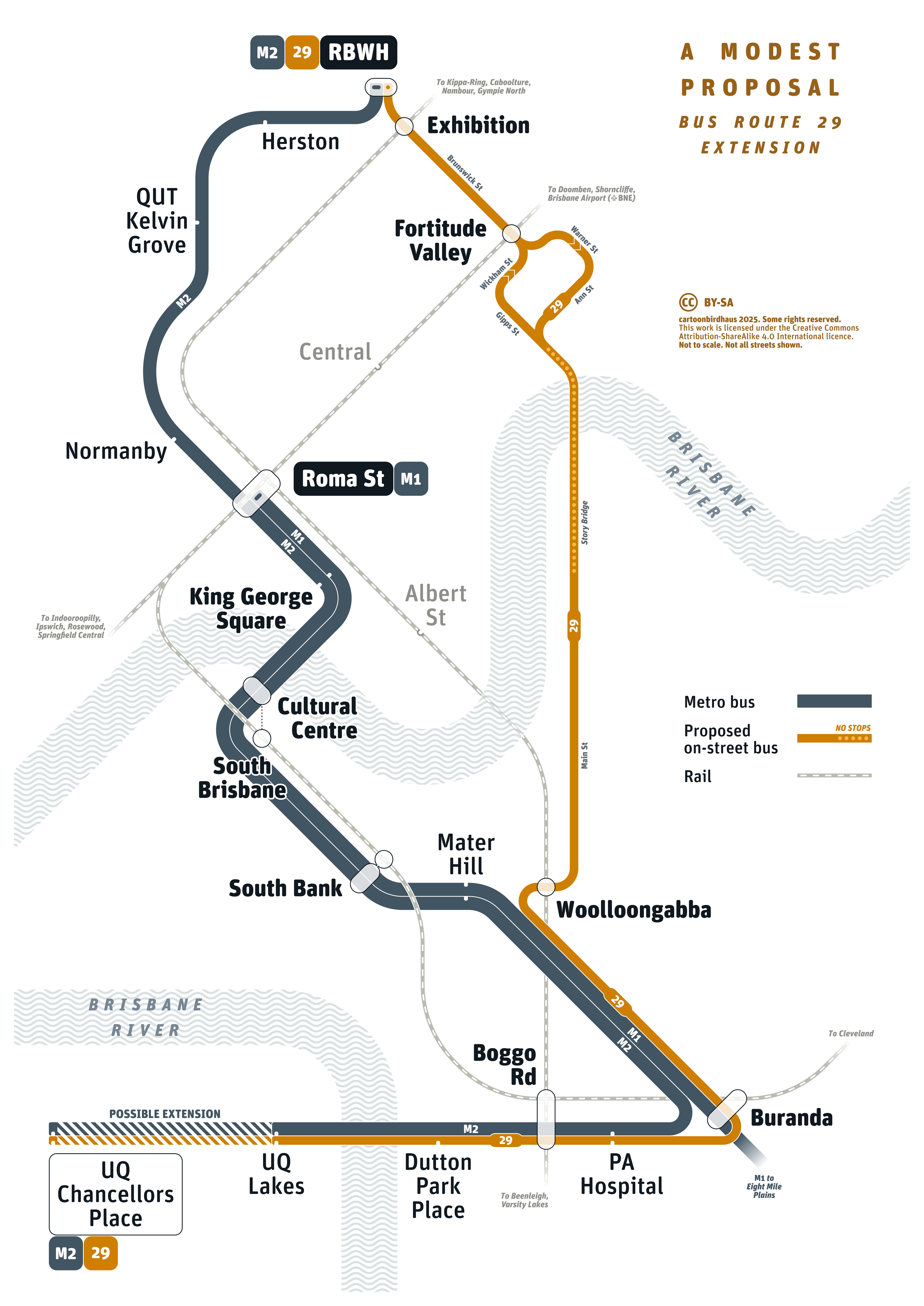
Theoretical bus route 29 extension for Brisbane by cartoonbirdhaus /o\, on Flickr
Option B: Via Kangaroo Point local streets (Preferred Option)

Theoretical bus route 29 extension for Brisbane (Variant) by cartoonbirdhaus /o\, on Flickr
Kangaroo Point is definitely in need for some better public transport. An inner-city suburb with multiple high-rises without any form of public transport (not even a simple bus route).
It would be great If they could put at least a high-frequency bus route (like BUZ, CityGlider).
Looks good! Only question I have is logistically how does the route 29 stop at Buranda when it’s past the turnoff to UQ?
These maps are so hot
I think you mean route 26 and I agree this could go to to UQ via Buranda instead of Upper Mount Gravatt. It could be rebranded to an all day Glider as well.
I also find that those Northern services terminating at PO Sq is not ideal. Inbound they (348/347/338) should continue down Queen then Eagle Tce up Margaret (Interchange at Albert St with CRR) then loop back outbound via George and Adelaide Streets.
After departing Woolloongabba the proposed Route 29 stops at Buranda. It then turns left and up a ramp into O’Keefe St. It travels about 200m along O’Keefe St and turns right into the O’Keefe St busway portal, travelling to PA Hospital, Boggo Rd, etc.
So it first exits then re-enters the busway.
One the way back, it would have to stop underneath at P.A. Hospital station as you can’t turn right to acces O’Keefe St prior to the Harrogate St tunnel.
Thanks for highlighting this.
Interestingly, there are a few places where buses make turns on the SEB, but there is no actual bus turn lane.
Examples:
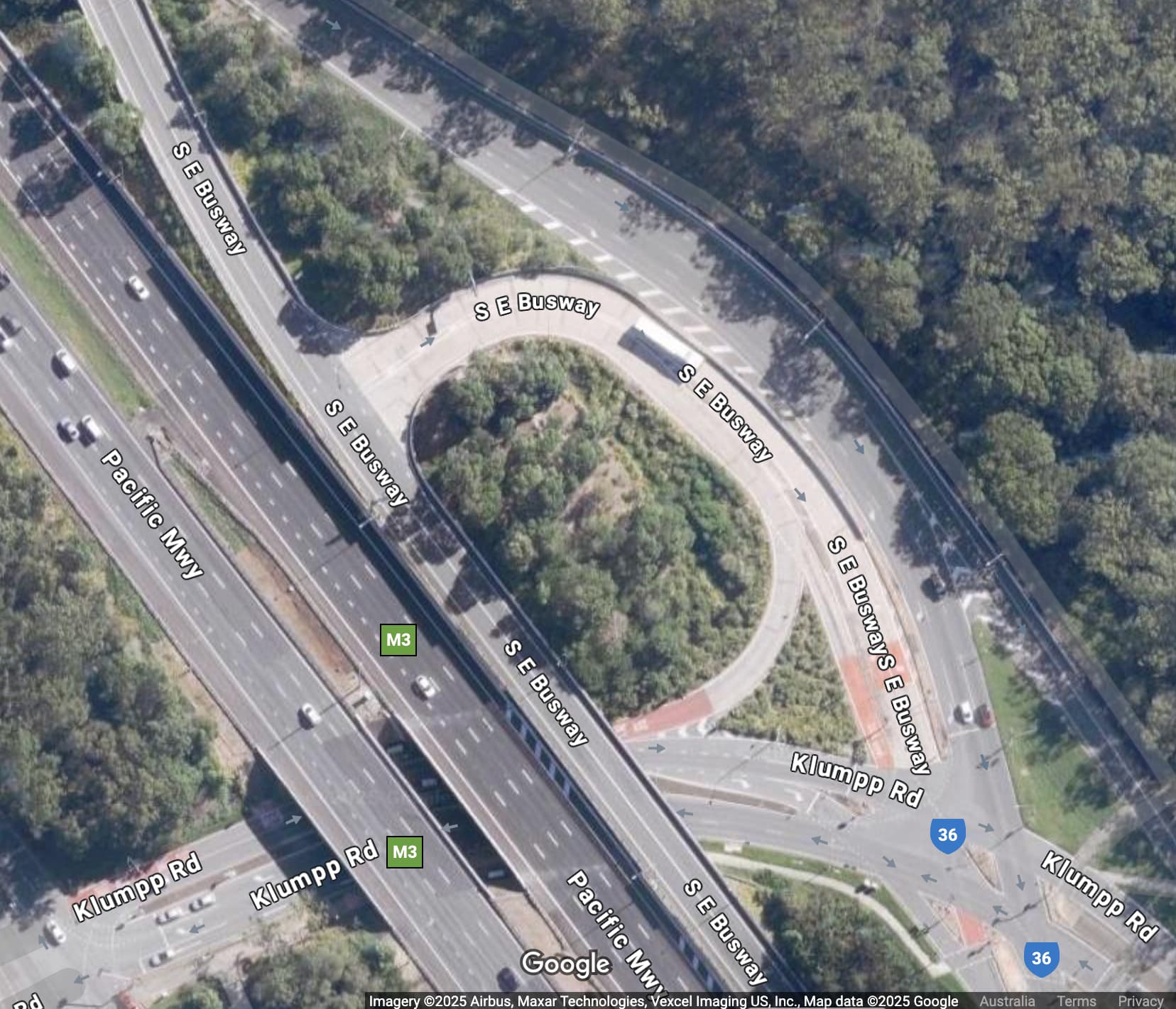
Klumpp Rd turnoff:
Garden City Depot Access Rd:
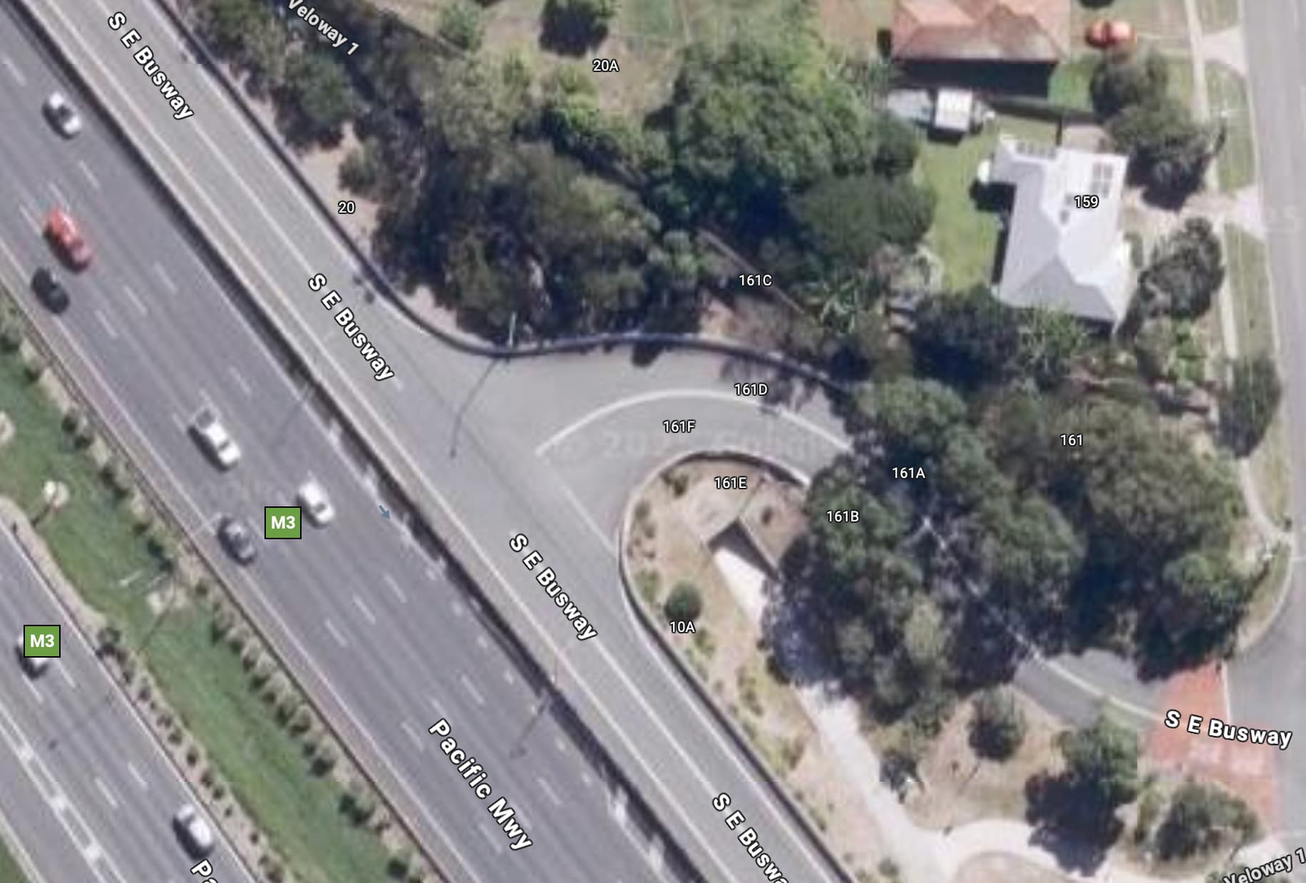
Birdwood Road:
It may be possible to modify this through new line markings. Ideally a lane for turning should be provided.
As discussed at length in another thread, the Route 26 is already picking up decent pax between UMG and Buranda who are boarding specifically to access locations along Kangaroo Point (not a single person who boarded the bus I travelled on got off before Woolloongabba). I feel there is enough demand there to retain it (and possibly expand it) as a useful cross town link.
Extending the 29 across KP and up to RBWH as well, is definitely something I could get behind through.
Thanks for your support ![]()
Is there really a need for bus turn lanes at these exits though? Taking Klumpp Road as an example, are there that many services that travel northbound up the busway that exit the busway here? I can think of just one route off the top of my head (116). The vast majority of buses are heading southbound and turn off to the left, not requiring a turning lane.
Similar question for Birdwood Road. Aren’t all the buses exiting here heading southbound?
The one at Garden City you may have a point with. Although that point may have been stronger prior to the BNBN, with the buses from Logan that terminated here (now extended to the Griffith turnaround). As it is now, are there any in service buses that still exit the busway to service the interchange? Even if not, perhaps it might still be worthwhile for out of service buses returning to the depot?
Thanks for your reply. For clarification, i’m not advocating for turn lanes at these imaged locations.
Rather, pointing out you could add one at the O’Keefe St portal if desired. The bus could probably make the right turn into O’Keefe St when travelling inbound from PA Hospital without the lane.
I believe the reason the turn was banned was due to line of sight issues with buses coming out of the Harrogate St tunnel.
The 234 exists. The span of hours and frequency is pretty bad, but it’s there.
I wonder what effect an extended 29 might have on it? If the 29 is to go via KP surface streets, the 234 is effectively pointless.
Maybe combining the 234 with the 29 and calling it the 239? Though I’d recommend the connection to RBWH due to the green bridge and the Holman street ferry both connecting to the city (don’t have a strong opinion though, as city connections are still quite important)
I’d nominate the 369 to be extend to Hamilton Northshore from Toombul.
I’ve tinkered with several areas across the BCC network. Locally in my area, I’ve rearranged the routes to ensure that Camp Hill Maketplace has all services (202 - which I’d renumber to 207), 203, 201, 205, 208) servicing those shops.
I had a thought along similar lines. Essentially split the 234 into two routes and absorb some of the 29 trips by extending to UQ Lakes.
The 234 would start at UQ Lakes, via the 29 to the Gabba, then Main St (omit the Baildon St loop as people have ferry access for the city), then via Ivory St, Adelaide St, Edward, Elizabeth, Queen, Adelaide St, Ivory St tunnel and then the reverse of the above.
The 239 would start UQ Lakes, 29 to Gabba, then pick up the current 234 route including the Baildon St loop under the bridge. Once it crossed the Story Bridge, left Ann St serving the 2nd Valley Island (Stop 217), then around Centenary Place onto Wickham St, servicing a stop near Gotha St, then Stop 228 Wickham St, then via Ballow St, Ann St and back onto the bridge doing the reverse of the above. This would provide Kangaroo Point with a direct service to the Valley (along with UQ).
29 services would fit in between these services to maintain a good frequency between the Gabba and UQ combining the 29, 234 & 239.
Since this idea, BNBN implemented the 26 as well as removing Stop 217 so the idea would have to be altered now.