Included was $123 million for 96 property resumptions. Not an insignificant sum.
That would be the best outcome for sure, but I am not confident that will happen. Be interesting to see what the Metro bus extension business case comes up with.
3 Likes
So that’s why you convert the riverside expressway into a reliever busway. The students at QUT would praise you for that as it would also give them a direct busway connection between their two campuses. Convert one bridge into this busway and the other bridge into a green walk, something like New Yorks High Line.
1 Like
It will probably suggest a Toll road tunnel under Old Cleveland Road or something stupid like that.
1 Like
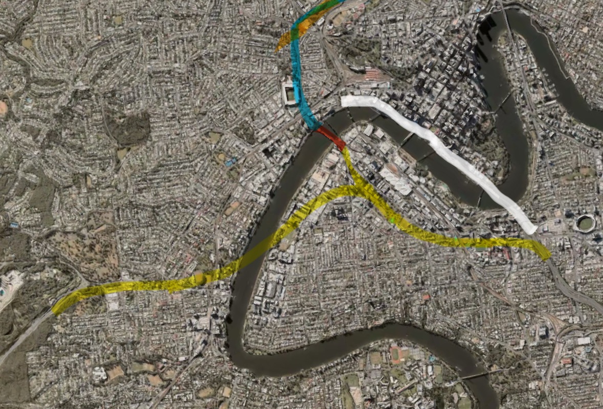
I know I am mostly opposed to building new road tunnels but we could build the east west link to replace the riverside expressway. And it can include connection with go between bridge. Meanwhile the riverside expressway will see one bridge turned into a reliever busway and will serve new areas on the riverside like QUT Gardens Point, and Queens Wharf. Maybe even an interchange stop next to Adelaide street. The other bridge will become a green walk like New Yorks high line. As for road tunnel, first stage will connect the pacific highway to go between bridge and second stage will connect it further to the western freeway. Yellow highlight is new tunnel, red highlight is the go between bridge, light blue is ICB and the white is the riverside expressway which will be converted from motorway to public transport. Then we could build a tunnel under old Cleveland road to meet with this tunnel and include a busway with it.
1 Like
IMO if an alternative like this to the Riverside Expressway is built, then the thing to do is to tear it down and reclaim the North Bank. It’s prime riverside land that should be public space like South Bank, not an urban highway.
11 Likes
Problem with the BAT is though in concept it was good, the main issue was trying to evacuate everyone if there was an emergency or if a fire broke out in the tunnel because not only would you need to evacuate everyone off the trains but also would have to evacuate everyone off the buses. All up it would have also affected half the transport network. Lastly the BAT also would of required a stupidly huge TBM so it wouldn’t of exactly been cheap.
With the coming closure of Griffith University Mt Gravatt campus now only a few months away.
Is there any whispers out there about what the griffith university busway station will be re-named to.
I genuinely don’t have any decent suggestions as it really only serve interchange purposes. There isn’t much around the busway station itself.
2 Likes
I think it’ll be called ‘Griffith University’ busway station indefinitely, if I’m being quite frank.
Although, it’s an interesting conversation to be had. Because maybe one day, Holland Park West busway station should be renamed to ‘Tarragindi busway station’, as it borders both suburbs.
Heck, maybe even ‘HPW-Tarragindi busway station’ if council wants to get creative ![]()
1 Like
I guess they can follow in the footsteps of ‘KGS-City Hall’ and ‘Boggo Road-Park Road’ with "‘Holland Park West-Tarragindi’ ![]()
1 Like
How about Toohey Forest Station? It’s the only nearby landmark I can think of.
3 Likes
does anyone know what they’ll do with the land/buildings at Griffith Uni Mt Gravatt?
It was mentioned a while back at RaTLR. I can’t recall what exactly came about it though unfortunately. @alexjago, do you remember?
1 Like
If we can have 3 separate Wynnums, we can have Upper Mount Gravatt and Mount Gravatt.
2 Likes
“Formerly Griffith University Bus Station”
It’s a really good place for a TOD IMO. The PT is right there. The buildings could perhaps become high density student or mixed housing.
2 Likes
I think it would be nice to do a First Nations name or going basic with “Toohey Forest Station”.
“Nathan Station” or “Mount Gravatt Station” could work too ![]()
2 Likes
It kills me how there’s no ‘Lower Moumt Gravatt’ or ‘Mount Gravatt West’
3 Likes
But we really wish we didn’t…
It’s likely to remain an education facility of some sort. Might make the most sense to hold renaming until the future of what’s going there is known and name it accordingly if sensible?
The student accommodation buildings that were there have been demolished. After they were considered too much of a fire risk for crisis accommodation. Apparently safe enough for the years I lived there though ![]()
2 Likes
So, it is except it isn’t. The area is a big fire risk, so dont expect anything TOD to be proposed there.
2 Likes
Last I read, RATLR were using the working title of Toohey Forest Station, but I REALLY do not like this name because it has the potential to be extremely misleading.
The reason for this is that the forest surrounding Mt Gravatt Campus is not actually part of Toohey Forest. Toohey Forest is largely situated on the western side of the highway, above and to the North West of Griffith’s Nathan Campus. The main public recreation spaces (the picnic areas) of the park are centred around Toohey Road in Nathan/Salisbury, with the official address for Toohey Forest being 600 Toohey Road, Nathan.
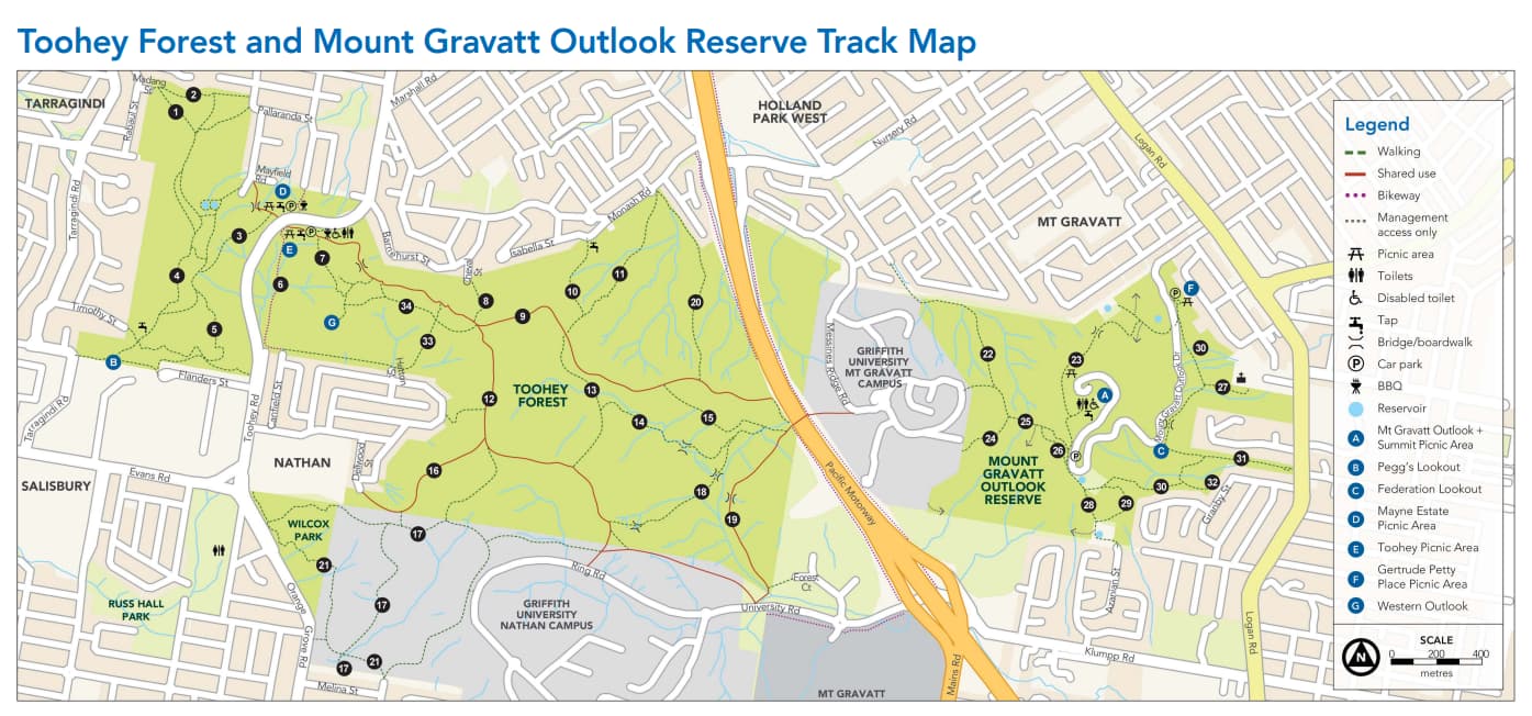
To me, naming this station Toohey Forest would be like having a ‘Mt Coot-Tha Station’ in The Gap - it may not be complete inaccurate, but that’s not the location most people associate with Mt Coot-tha. Calling it Mount Gravatt Outlook Reserve does have a similar issue as it’s not completely accurate either, but I would more closely associate the campus site as being part of the reserve than part of Toohey.
6 Likes