When we looked at this network internally at TL in 2006, we proposed extending the 227 (then known as the 222) to Wynnum Central as we saw Wynnum Central as a bigger patronage attractor than Manly.
1 Like
The 224 (and the 223 for that matter) does get patronage. It wouldn’t be as much as the 220 obviously, but it does fill in the gaps the 220 doesn’t service and would be practically impossible to service.
2 Likes
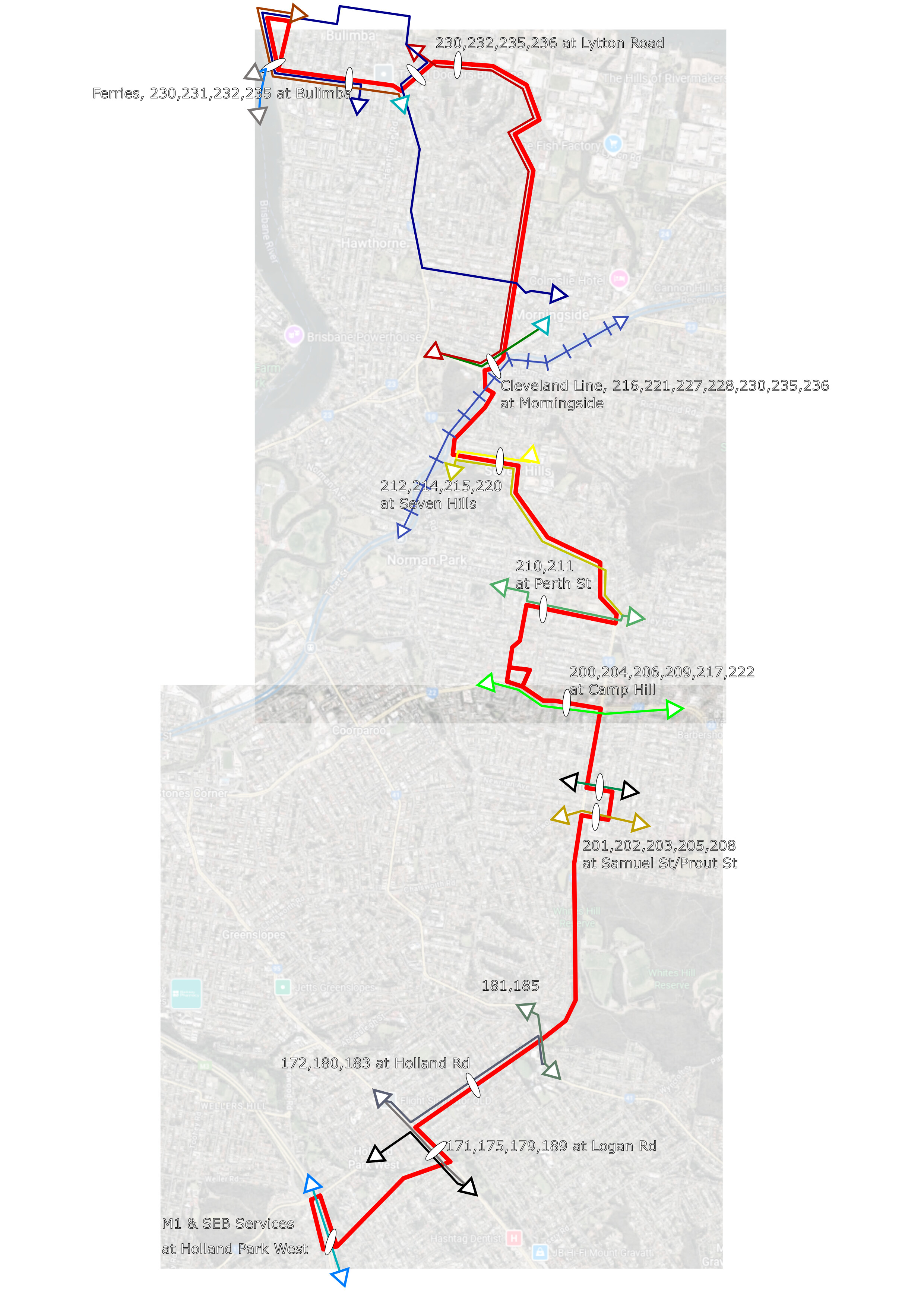
Was thinking about this in the past few days, and also in the GCL posts, about adding more cross-town routes. This would be my proposal for a closer to the city route roughly following state route 10 (as the 590/GCL roughly follow state route 20). I decided to terminate it at Holland Park West, as it is the ideal location for a turn around (and already has buses turning around there). I decided to terminate it at Bulimba as it is a hub with many shops, and has good ferry connections, including to route 60 via the cross river ferry service. I also tried to maximise same-stop transfers (e.g. with the 222 service) as it makes transfers much easier, while also trying to maximise it being a direct service - this is why the service follows Logan Road and Old Cleveland Road for a bit.
I’m curious of what people think, and if we should implement this/what changes to the route would make it better
5 Likes
I have often wondered about the viability of a route heading south from the Bulimba/Balmoral area. In my mind it, a route would have ended at somewhere like Garden City. Thanks for sharing.
3 Likes
A fantasy, high-frequency bus route that will never happen ![]()
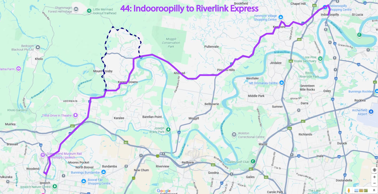
Proposal: 44 Indooroopilly to Riverlink via Karana Downs and Anstead.
Average frequency will be 30-45 minutes, with the occasional diversion via Mt Crosby.
“The uglier cousin of 444 Moggill BUZ”
(Shout out to all the Karana Downs, Mt Crosby, and Chuwar residents whom still don’t have a bus service, despite being honest ratepayers to Brisbane City Council) ![]()
5 Likes
As for any lofty potential extensions for the 444 BUZ, the state budget has stipulated that the 444 will in fact be extended to Moggill District Sports Park.
Apparently, Moggill Ferry as a terminus would’ve been a ‘logistical nightmare’ which is unfortunate.
But hopefully one day there’ll be a footpath to Moggill Ferry from Bellbowrie, as currently there is none.
4 Likes
Honestly, probably wouldn’t be too bad of a suburban route, though I would have people transferring to the 444 at Bellbowrie - perhaps at Montanus Drive - and turning around at eastern Moggill, where there’s also no current bus service
1 Like
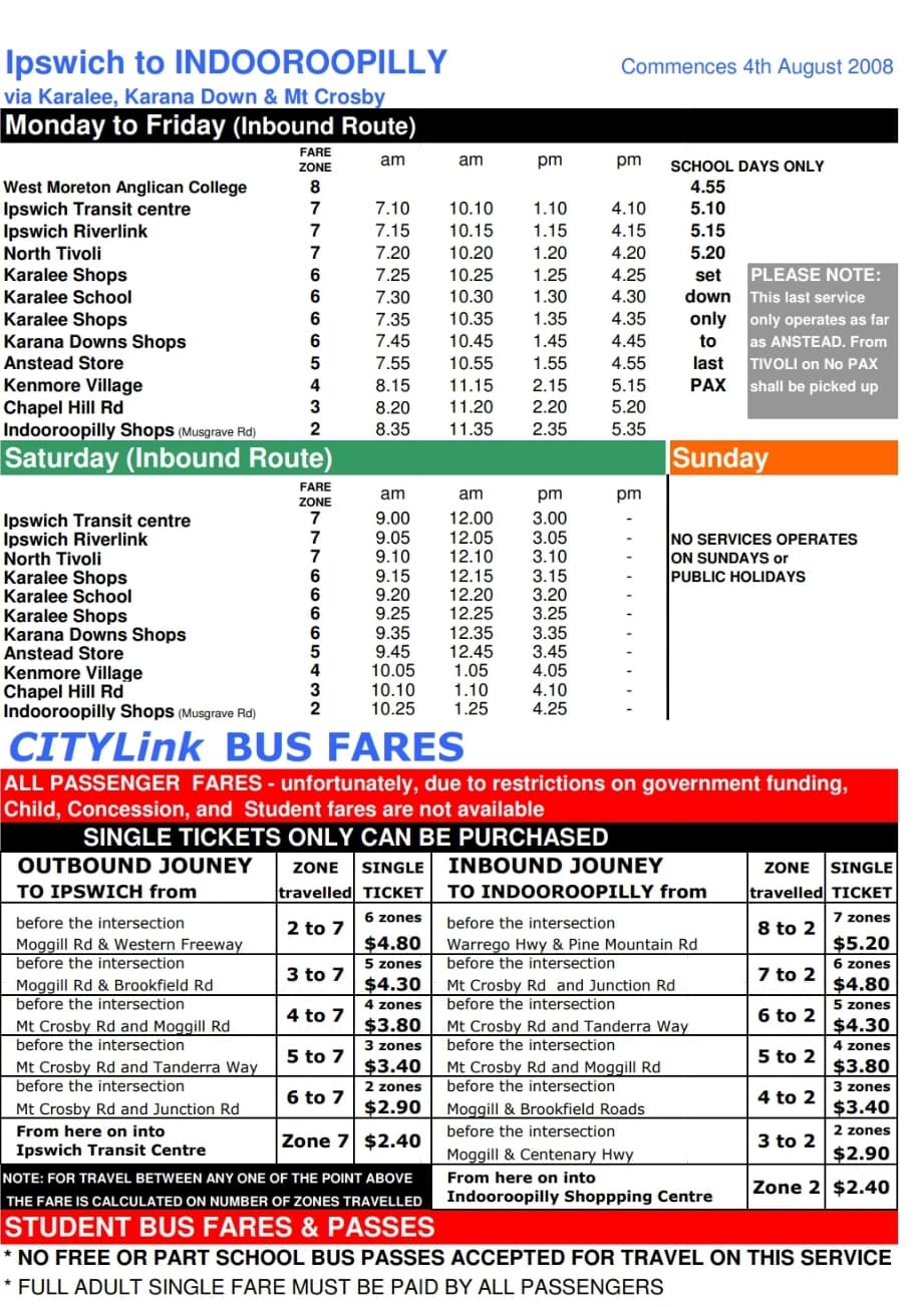
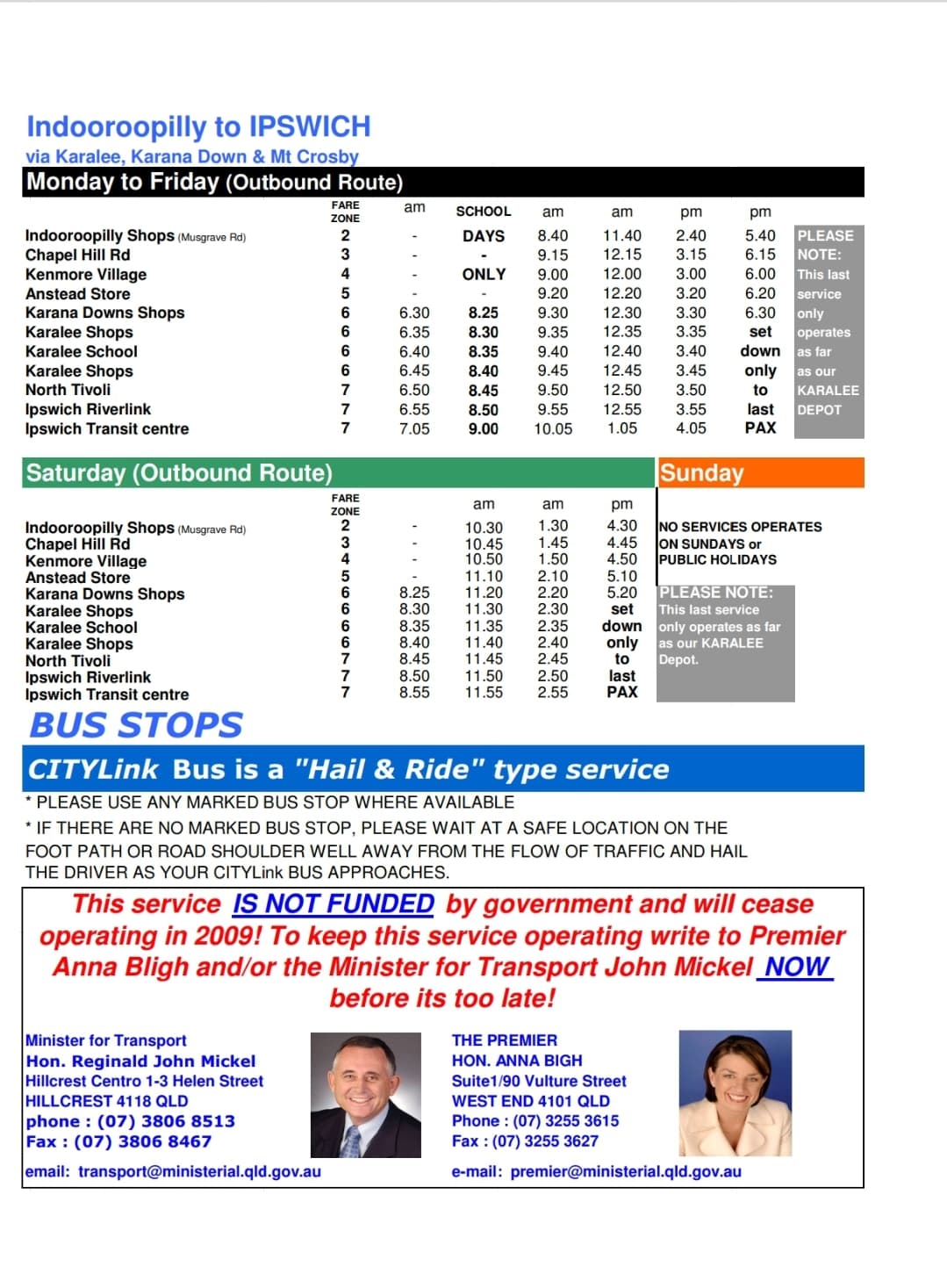
We actually had this up until 2009, in the form of an Ipswich-Indooroopilly express run by Southern Cross Transit. It was withdrawn due to a lack of public funding iirc
*edit* I found the old timetable https://www.southerncrosstransit.com.au/_files/ugd/3c9c82_657efbc2889c4160bb3a0af31c858960.pdf
4 Likes
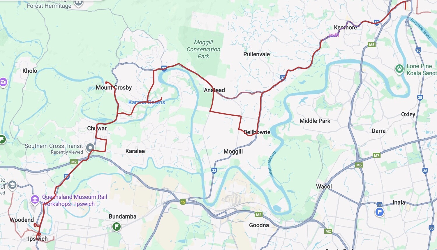
I drew up this similar (albeit slower and less frequent) proposal a while back for a 449 Ipswich-Bellbowrie via Karalee and Karana Downs.
It would both serve as a cross-town service between Western Brisbane and Ipswich, and provide local access for residents in housing estates in Karana Downs (and especially) Karalee. Karalee even has translink-branded bus stops with no public bus service.
It also means that the 514 won’t have to do that diversion up to Tivoli, providing faster service for passengers in Moores Pocket.
I can’t find the original map I did up for it, but I included it in this westside bus network map I proposed (inspired by the old RBOT proposed network) –> Westside Buses – Google My Maps
3 Likes
this has me thinking now, I think a combination of both routes would be best? like, an express Indro variation during peak hour for commuters and school kids, but then a Bellbowrie variation during off peak hours for shoppers. I might see if I can come up with a proposed timetable
an unrelated tangent, but Anytrip seems to list “Devils Elbow” and “Stanton Cross” as suburbs in Karalee and Chuwar, despite very little evidence of these localities existing
2 Likes
Can’t believe it had an average frequency of 2-3 hours ![]()
It would appear as though the Riverlink-Indooroopilly bus route ceased operations in 2009 from the source.
1 Like
yeah that frequency was crazy - although, it would’ve ceased operations before Karalee really got developed so I’m not sure how many passengers it would actually get.
Also I can’t believe it went through 6 zones!
2 Likes
I was expecting to have to trawl through the archives to find that document, idk why Southern Cross Transit still has it up on their website
I did find this letter though, apparently it got good patronage Wayback Machine
1 Like
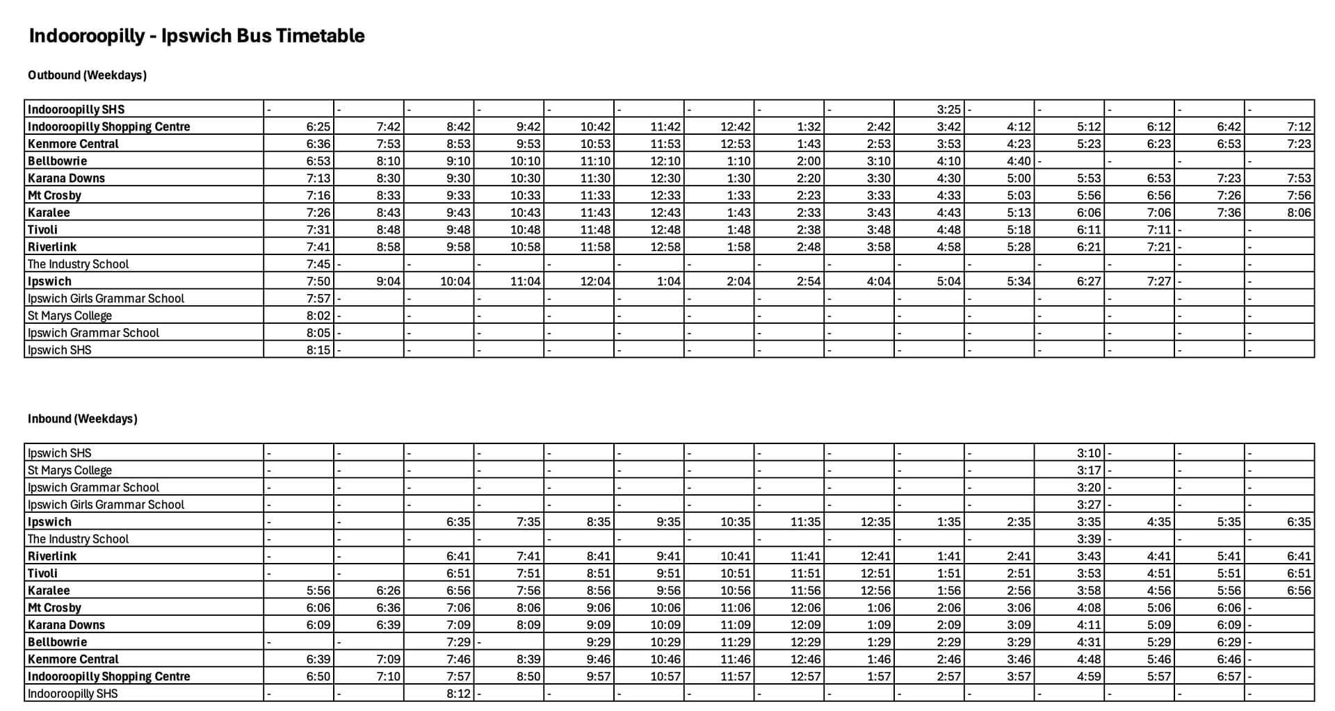
I made a timetable for a potential new Indroopilly - Ipswich bus route. It would require 4 buses from Southern Cross Transit, running throughout the day, and has school variations on both the Indro and Ipswich end. Some peak services only run for part of the route, and some of these require blank running from one end of the route to the other. The service would run all-stops, skipping Bellbowrie in peak directions.
3 Likes
I would like to see a direct bus route from Kippa-Ring Station to Sandgate Station.
Currently, to travel between the two requires either an hour-long tour around the peninsula on Route 690, or depending on time of tday, one of these transfers:
- Taking 660 to Anzac Ave at Museum and Historical Society, Redcliffe then crossing Anzac Ave (signalised), and a slip lane (not signalised, and not a hump zebra crossing, so against TMR best practice), transferring to 690 at Oxley Ave at Humpybong Park, Redcliffe. I do not consider this a good transfer due to safety concerns regarding the slip lane. The long cycle of traffic lights at this intersection could also lead to missed transfers, given the 6-minute transfer window, and the possibility of services running slightly late or early
- Taking 660 to Anzac Avenue near Recreation St (near Redcliffe Hospital), and transferring to a 691 departing Victoria Ave at Anzac Avenue. Fortunately, there is no slip lane invovled here, but there is still a requirement to cross Anzac Ave.
- Taking 696 to Victoria Ave at Anzac Avenue, Redcliffe and a same-stop transfer to 691. This is a 6-minute transfer, but it is at the same stop, so this is acceptable.
- Taking 694 to Hornibrook Esp at Clontarf Beach East, Clontarf (Moreton Bay Regional) then transferring to 691. This is a same-stop transfer, but a 14 minute transfer time. This, IMO, is not acceptable.
To me, this is far too confusing, with too many options, when a line-haul bus route should be easy to catch. Travel time is also an issue.
In the off-peak, Kippa-Ring trains arrive at :16 and :46. Cleveland trains depart Sandgate at 11: and :41
In the other direction, Shorncliffe trains arrive Sandgate at :18 and :48. Springfield Central trains depart Kippa-Ring at :16 and :46
So, from Kippa-Ring to Shorncliffe, we want a travel time of no more than 35 minutes. Allowing a 6-minute transfer at each end takes this down to 23 minutes. According to Google Maps, driving time without traffic is 15 minutes, allowing 8 minutes for stops. Perhaps it will need to be a limited-stops service, and the 690/691 pair can take up the less-used stops.
In the other direction, ideally the trip should be done in 28 minutes, so that the bus departing Sandgate after the :18 train can reach Kippa-Ring in time for the :46 train. I am not sure this is feasible. The transfer time would need to be cut down to maybe 4 minutes at each end, and stops would need to be very limited. Does anyone have any thoughts on the feasability of achieiving this?
Suggested stops (southbound):
- Kippa Ring Station
- Elizabeth Ave near Angus St, Clontarf (interchange with 694)
- Hornibrook Hwy at Eventide Aged Home, Brighton (interchange with 690 & 691; Brighton Health Campus)
- Beaconsfield Tce near Twelfth Ave (access to Brighton Hotel & Brighton Bowls Club)
- Sandgate Station
An equal number of stops in similar locations northbound.
Service to run every 30 minutes during off-peak times from first to last train. Peak services TBA.
2 Likes
Personally I’d send this route to Bellbowrie and no further, with it connecting to the 444, no need to duplicate the 444 with this route and complicate the network. Also, I don’t think it needs to do that one trip up to Mount Crosby, I’d be dubious about the demand for that, ie: is that area really getting busloads of people up there?
Just as a side note, myself and the Senior Planner at the time did look at introducing a new bus route through Karalee and Kawana Downs in 2008 to Ipswich, unfortunately we were blocked due to the contract boundaries and conditions at the time. Essentially the contract boundary for then Westside ended at the Warrego Highway so we weren’t allowed to send Westside into Southern Cross Transit’s contract area without making TransLink liable for Southern Cross Transit potentially suing TransLink for potential loss of income and breach of their contract of having exclusive use of that area in Karralee and Kawana Downs. I’m not sure what the contract conditions and boundaries are nowadays, but hopefully that has since been resolved.
4 Likes
Theres the 690 and 691 that alternates the routes with 690 go via reddy jetty and scarby first while other go more direct to kippa ring then go other parts of RP - both from sandgate. I know 690 better but not the other well enough tho
Edit. Just looked up…defs needs to edit the 691 to go up snooker st to kippa ring then snake thru the area a bit b4 reddy hospital up to scarbyb
1 Like
Living on the insular peninsula myself, I actually thought of a slightly different idea. Truncate the 690 at Kippa Ring Station. Have a new route that goes Redcliffe Jetty - Kippa Ring Station - Deagon - Chermside.
Proposed routing would be existing 660/680 to Kippa Ring Station, then via the 690 route to Duffield Rd, then left Snook St/Elizabeth Ave, over the bridge, Deagon Deviation, Braun St, Sandgate Rd (Iceworld stop is a short walk to Boondall North train station), Roghan Rd, Handford/Murphy Rd to Chermside. Has option to use Kittyhawk Dr to access Chermside as well. The return route would have the option of going Roghan, Carlyle, Lydnhurst (stop opposite Boondall North station), Holroyd, Sandgate Rd. The routing would provide connections to other routes at Deagon as well as a faster journey to Chermside from Redcliffe. It would also allow local journeys along Roghan Rd which has significant walking distances to bus routes. It also serves Zillmere Station as well.
Other changes I would implement would be splitting the 680 up into two routes at Strathpine. There is the option to split it again at North Lakes but I am not keen on removing a direct link to Redcliffe Hospital.
3 Likes
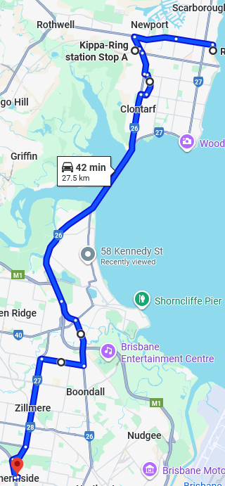
Does this look about right (for the southbound route)? It’s going to be pretty long, probably an hour plus, and more in traffic. 42 minute driving in no traffic, that’s with no stops.
I think splitting the 680 is definitely a good idea! The route is far too long, approaching 2 hours at times (e.g. school days departing Redcliffe at 7:39 am takes 1 hr 57 minutes). This is absurd for a suburban bus route IMO.
3 Likes